

The
Storms of Arctic Warming: Polar Amplification, Vortex Disruption to
Set off Extreme Weather Events For US, UK Yet Again

28
February, 2014
It’s
happening again.
A
story that starts in the Arctic where abnormally warm temperatures
for this time of year are in the process of disrupting the polar
vortex, shoving its node out of the Arctic Ocean and pushing it all
the way south over Hudson and Baffin Bay.
The result is a core of
extreme cold shoved much closer to related warmer, southerly regions.
A highly unstable event that is likely to spawn extreme weather for
the US and UK yet again.
This
polar heat amplification and related extreme weather is a signature
of human-caused global warming. And though it wears a grotesque mask
of what some would call a normal Arctic oscillation, it is anything
but.
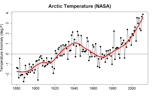
Our
rapid production of greenhouse gasses since 1880 has caused the
Arctic to warm, on average, by about 5.3 F (3.0 C). This rapid
increase in warming is nearly 4 times that of the global average and
resulted in temperatures for the Arctic, during the 20th Century,
reaching a range not seen in at least 44,000 years and likely 120,000
years.
Since warming has continued well into the first and second decades of
the 21rst Century, Arctic temperature excursions are likely outside
even that extreme range and may well now be approaching averages when
parts of today’s Arctic first began to freeze and glaciate.
The
causes of this rapid Arctic amplification are manifold. First, human
greenhouse gas emissions added more heat to the oceans and
atmosphere. The polar sea ice, sitting atop a warming ocean went
though a period of recession from the 1920s through the 1950s,
hovered in about the same zone during the 60s and 70s and then
commenced a more rapid melt phase from the 1980s onward.
Loss
of Sea Ice and a Changing Jet Stream
Loss
of sea ice reduced
northern polar albedo (reflectivity) by a total of 4% since 1980
which increased Arctic heat capture by an amazing 6.4 watts per meter
squared (more
than 4 times that of human CO2 forcing over the entire globe). As a
result, the seas under the Arctic ice cap began to even more rapidly
warm. By 2012 the warming was intense enough to have reduced
end-summer sea ice volume by 80 percent since 1979. Now, during
winter time, a perforated and much diminished sheet of sea ice bleeds
ocean heat into the Arctic atmosphere. As a result, cold air tends to
be shoved out of the Arctic Ocean basin more and more often.

This
bleeding of oceanic heat has bent the Jet Stream ever northward over
two zones — one over Svalbard and one over Alaska. And both these
Jet Stream weaknesses allow warmer air to rush into the Arctic from
the south. These various heat forcings cause the winter time polar
vortex to wobble uneasily over a warming Arctic Ocean even as it is
more frequently ripped apart by warm air incursions through the
oceanic weak points. Meanwhile, these vortex disruption and collapse
events spill cold air southward over the continents and into the
Atlantic Ocean.
Yet
one more Polar Vortex Disruption
And
for this winter, such Arctic heat driven polar vortex disruption and
collapse events have been the norm. This week is featuring yet one
more — sparking extreme weather that will revisit both the US and
UK over the coming days.

(Climate
Change Institute Map Showing Arctic Heat Anomaly 2.68 C above the,
already warmer than normal, 1979 to 2000 average. Image
source: Climate
Reanalyzer.)
Today,
the Arctic temperature anomaly was 2.68 degrees Celsius above the,
already warmer than normal, 1979 to 2000 average. Areas near
Svalbard, Alaska, and Baffin Bay showed extraordinary temperature
departures in the range of 15 to 20 degrees Celsius above average.
Meanwhile a zone of cold, Arctic air has been shoved southward over
the US, setting up extreme temperature differentials over a
relatively small area and putting in place conditions ripe for
extreme weather.
A
Tale of Three Storms
A
large Pacific storm now in the process of leaping over the west coast
blocking pattern is forecast to dump up to 5 inches of rain on a
parched California before injecting itself into the highly unstable
atmosphere over the central and eastern US. Areas in the center of
the US such as Oklahoma may experience a range of weather from
thunderstorms to tornadoes and precipitation running the gambit
between snow, hail, ice, and rain. This system is predicted to spread
out, covering a massive swath from Texas to Maine and incorporating
at least two low pressure systems. It will draw in a deep flow of
warmth and moisture from the Gulf of Mexico and this warm and
moisture laden air will abruptly collide with the much colder Arctic
air to the north. Extreme rain, ice and snowfall are certainly
possible as this intense event is expected to last from Saturday
through Monday.
Across
the Atlantic, as the Jet Stream invades southward and picks up speed,
a gale formed to the south of Greenland and Iceland before barreling
on into the storm ravaged shores of England and France. The gales and
storms this winter for the region have been relentless, resulting in
the stormiest winter ever on record for England and
creating conditions so battering and exhausting that more than 21,000
sea birds are thought to have tragically lost their lives in at sea
before washing up on French shores.
Now
a strong double barrel low pressure system is bringing gale force
winds and heavy rains back to a United Kingdom that has suffered an
almost constant assault of storms since the middle of December. Flood
warnings have again been issued for multiple counties and regions
just north of London, which experienced 60 degree temperatures
earlier this week, are expected to see snow. The storm is expected to
sweep through the UK on Friday and Saturday before exiting Sunday. A
storm of similar intensity is then expected to return to the UK on
Monday where the process of gales and floods are likely to again
repeat.

(Sediment
outflow from the swollen rivers of England and France on January 26
as yet another storm encroaches. Image source: Lance-Modis.)
In
total, this worst continuous period of storms in UK history, has
resulted in over a billion dollars in damages. Meanwhile, the storms
are expected to continue through at least early March.
Overall,
these extraordinary conditions cannot be entirely separated from the
still-high temperature deviations occurring in the Arctic. Usually,
by this time of year, the ice is solid enough and the warm air
incursions are weak enough to allow at least some minor
re-establishment of the polar vortex. Not so for 2014. The above
average temperatures throughout the Arctic continue and show little
sign of abatement as we head into March and the end of sea ice freeze
season.
Links:
No comments:
Post a Comment
Note: only a member of this blog may post a comment.