Subscribe to


Friday, 31 August 2018

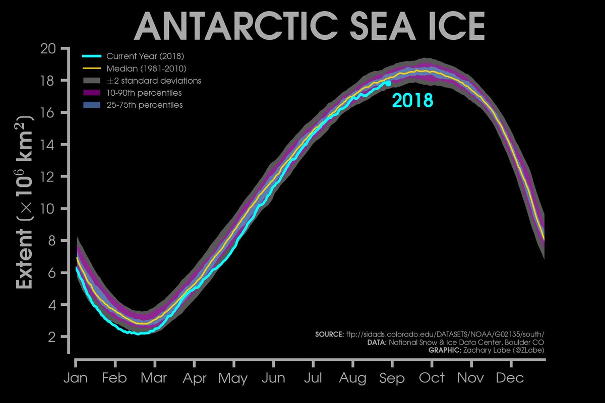
Antarctic ice 380,000km2 below average
Antarctic
ice at maximum well below average
You Retweeted

Antarctic sea ice reaches its annual maximum extent over the next few weeks. It is currently around 380,000 km² below average.
Graphic with @NSIDC data: http://sites.uci.edu/zlabe/antarctic-sea-ice-extentconcentration/ …
The Americans have deployed a camoflaged SAM system at al-Tanf, Syira
US-led
coalition seems to have deployed some kind of (SAM) system, covered
with a desert camo net, in Al-Tanf, Syria
31
August, 2018


US-led coalition seems to have deployed some kind of (SAM) system, covered with a desert camo net, in Al-Tanf, Syriaalready-happened.com/2018/08/30/us-…
“The US’s next step is to build a missile defense shield in the region which must be considered as a part of Washington’s long-term plan for chaos in the region,” Former Commander of Syria’s Deir ez-Zor Military Assembly Fayez Esmer told Yeni Safak newspaper on Tuesday.
Australia's bleak prognosis for spring
Australia:
Dry times to continue as BOM releases grim spring outlook

The
climate drivers are looking like they are just going to make things
worse this spring.
 PHOTO: Dry
conditions are expected for Southern Australia and in parts of the
interior, particularly in October.(Supplied:
Bureau of Meteorology )
PHOTO: Dry
conditions are expected for Southern Australia and in parts of the
interior, particularly in October.(Supplied:
Bureau of Meteorology )
 PHOTO: Autumn
and winter have been dry for swathes of Australia. (Supplied:
Bureau of Meteorology )
PHOTO: Autumn
and winter have been dry for swathes of Australia. (Supplied:
Bureau of Meteorology )
 PHOTO: This
drought-affected paddock on Jimmie and May McKeown's property is
located on the outskirts of town of Walgett, supplied by the Keepit
Dam. (Reuters:
David Gray)
PHOTO: This
drought-affected paddock on Jimmie and May McKeown's property is
located on the outskirts of town of Walgett, supplied by the Keepit
Dam. (Reuters:
David Gray)
But for Keepit there is no pipeline dream.
- Drier than average spring likely for southern Australia and parts of the interior
- Expect warm spring days
- Dry and warm spring would mean intensification of drought and increase fire potential

ABC,
30
August, 2014
The
Bureau of Meteorology has released its latest climate outlook, and
the forecast is grim.
It
has been a dry summer, followed by a dry autumn, followed by a dry
winter, for large parts of the country and it looks like spring is
going to follow the trend.
The
prolonged dry is starting to put a strain on water supplies, with
some communities dealing with dam levels down to 10 per cent.
"Unfortunately
for those that are having a close eye on rainfall, it does look
likely that we're going to see a drier than usual spring," BOM
Senior Climatologist Robyn Duell said
"So
this is going to compound the already dry conditions that we've been
experiencing across eastern Australia."
Ms
Duell said it's been the driest start to the year New South Wales has
seen since 1965.
"It's very comparable to some of the most severe rainfall deficits we've seen. It's been very unusually dry in the east."
Increased fire risk
For
most of mainland Australia the warm and dry start to the year has led
to dry soil moisture and dry vegetation.
"We've
already seen some bushfires in New South Wales during August which is
unusually early," Ms Duell said.
She
said there are a lot of elements that go into bushfire risk but this
spring's dryer and warmer outlook certainly has the potential to
increase fire risk.
But
while the drought has extended into parts of Queensland and Victoria,
not everywhere has been dry.
Western
Tasmania and south-west Western Australia have been very wet over the
past few months.
Climate drivers

A
Pacific Ocean phenomena with impacts around the world
The
bureau currently has an El Nino watch in place, indicating there is
twice the normal chance of El Nino, associated with dry conditions in
the country's north and east, forming in the coming months.
But
Ms Duell is not just focused on the Pacific.
"At
the moment we're keeping quite a close eye to the north-west of
Australia," she said.
"We've
had cooler than usual water there for a little while and sometimes
that can be the indication of the start of what we call the positive
Indian Ocean Dipole event."
Ms
Duell said cool water in the north-east can cause a change in the way
frontal systems move across the south of the country.
"They
often slip further south than they usually would," she said.
"That's
something that we've been seeing happening through winter and that
looks like it may continue to happen during spring."
PHOTO: Dry
conditions are expected for Southern Australia and in parts of the
interior, particularly in October.(Supplied:
Bureau of Meteorology )
The
outlook said low stream flows are expected to continue over the
south-eastern mainland through October, thanks to predicted dry
conditions on top of already dry soils.
Near
median and high flows, however, could eventuate on the south-west
coast of Western Australia and in Tasmania, where catchments are
already primed following good winter rains.
What does this mean for water supplies?
According
to the Bureau's water storage data, Sydney and Adelaide's water
supplies are both well down on last year.
The
situation varies greatly depending on where you are and how you are
getting your water.
Generally
the big city dams have a long way to go before they get into any real
trouble.
"The
Sydney situation is pretty good, but it's dry," WaterNSW
spokesman Tony Webber said.
"The
regions fluctuate from quite concerning to reasonably good."
But
it is where people are relying upon water outside the dam system that
things deteriorate.
"The
dry land farming situation, where people are reliant on waterways not
fed by dam storages, is actually quite dire," Mr Webber said.
Water
New South Wales has Sydney's water capacity at 65 per cent, despite
the dry catchments and low inflows.
PHOTO: Autumn
and winter have been dry for swathes of Australia. (Supplied:
Bureau of Meteorology )
"The
major dams that were talking about, even though we are seeing some
storages falling below what we prefer, they are very large storages
and they hold a lot of water," Mr Webber said.
"There
is up to two years' supply, even under the worst case scenario, for
the Sydney storages."
Variation in the regions
The
overall capacity of the regional dams
managed by WaterNSW is at 52 per cent, but according to Mr Webber
that figure does not tell the whole story.
"In
the south of the state, the dam storages that feed the Murrumbidgee
are actually in quite a good situation, water security wise.
Blowering and Burrinjuck Dams both are well stocked," he said.
"In
the central regions of the state Wyangala Dam on the Lachlan River,
which was the scene of that extensive flooding in 2016, it still sits
at 59 per cent."
Others,
like Burrendong Dam in the Macquarie Valley, which is at 32 per cent,
are starting to feel the strain.
"The situation is getting a little bit tighter there, but they have very, very big storages. So that's still a long period of supply."
Who is running out of water?
PHOTO: This
drought-affected paddock on Jimmie and May McKeown's property is
located on the outskirts of town of Walgett, supplied by the Keepit
Dam. (Reuters:
David Gray)
The
real pinch points, according to Mr Webber, are the Keepit Dam in the
state's north and the Menindee Lakes in the west.
Both
are down around 10 percent of capacity and the outlook does not
inspire a huge amount of hope in either case.
Menindee
Lakes provides water for the nearby city of Broken Hill and also down
the lower Darling river to the Murray.
Broken
Hill only received 9.4mm of rain from the first of June to the 28th
of August this year — just 18 percent of the average.
Mr
Webber said if there are not any significant inflows into the lakes
releases into the lower Darling may cease by December this year.
The
aim is to hold supply for Broken Hill while a pipeline is built to
link the town directly to the Murray River.
According
to Mr Webber, the pipeline will be completed by the end of the year
and will provide water security for Broken Hill.
But for Keepit there is no pipeline dream.
Mr
Webber said Water NSW has been working with local landholders and
communities to ensure essential human needs can be provided.
"Rather
than releasing water subject to water orders from customers
individually, it would really be just a more significant, perhaps a
one-off or series of releases at an agreed time," Mr Webber said
of a possible contingency plan should worse come to worst.
"So
that people with basic stock and domestic access rights can top up
their storage.
"Just
to make sure they've got at least an extended water supply while we
wait for the weather to change."
Mr
Webber said the water security situation for most water customers is
quite good but he does not want to give those suffering false hope.
"The dry land farming situation for farmers reliant on naturally occurring waterways is quite dire
New
Zealand: NIWA
Seasonal Climate Outlook:
Spring 2018
In New Zealand NIWA is a bit light-on-it and there has been nothing in the media.
Research: Arctic ice is melting from below
Scientists
find pocket of warm water trapped under Arctic with potential to melt
entire ice pack
Pocket
of water blown from hundreds of miles away could leave Canadian Basin
ice-free for much of the year

30
August, 2018
A
warm region of water trapped deep below the surface of
the Arctic seas
north of Canada has the potential to leave the entire area devoid of
ice.
Scientists
have discovered warmer water that originated hundreds of miles away
has penetrated deep below the ice pack’s surface.
Vast
swathes of the polar expanse are changing dramatically every year –
with sea ice vanishing far earlier in the season that it used to, and
ships beginning to take advantage of the newly ice-free oceans.
This
effect could be exacerbated in one of the Arctic Ocean’s major
regions – known as the Canadian Basin – by the influx of warmer
water that is currently stored underneath it.
Using
data collected over the past 30 years, researchers at Yale University
and Woods Hole Oceanographic Institution saw the “heat content”
of the area had doubled during this period.
They
were able to trace this water to the Chukchi Sea further south, where
the regional decline in sea ice has left the water very exposed to
the summer sun.
After
heating up, this water has been driven north by Arctic winds, but has
remained below the top layer of water – resulting in a
high-temperature zone trapped far beneath the ice pack.
“This
means the effects of sea-ice loss are not limited to the ice-free
regions themselves, but also lead to increased heat accumulation in
the interior of the Arctic Ocean that can have climate effects well
beyond the summer season,” said Yale geologist Professor
Mary-Louise Timmermans, who led the study.
“Presently
this heat is trapped below the surface layer. Should it be mixed up
to the surface, there is enough heat to entirely melt the sea-ice
pack that covers this region for most of the year.”
The
Arctic is warming at twice the rate of the global average, and year
after year bodies like the US National Oceanic and Atmospheric
Administration report record-breaking climate
extremes in
the region.
Last
year saw the lowest ever measurements for maximum winter sea ice
cover across the Arctic, and the second warmest air temperatures on
record.
These
changes have caused havoc for the people and animals that inhabit the
polar region.
Almost
all the ice covering the Bering Sea in the northern Pacific Ocean
vanished a month early this year, impacting the hunting and fishing
activities of the inhabitants of western Alaska.
The
recent breakup
of the “last holdout” of thickest ice in the Arctic was
described as “highly unusual” by scientists.
This
breakup is an unsettling sign of climate change, and experts warned
that it would likely have a serious impact on the region’s polar
bears and seals.


Arctic
sea ice isn’t just threatened by the melting of ice around its
edges, a new study has found: Warmer water that originated hundreds
of miles away has penetrated deep into the interior of the Arctic.
That
“archived” heat, currently trapped below the surface, has the
potential to melt the region’s entire sea-ice pack if it reaches
the surface, researchers say.
“We
document a striking ocean warming in one of the main basins of the
interior Arctic Ocean, the Canadian Basin,” said lead
author Mary-Louise
Timmermans,
a professor of geology and geophysics at Yale University.
The
upper ocean in the Canadian Basin has seen a two-fold increase in
heat content over the past 30 years, the researchers said. They
traced the source to waters hundreds of miles to the south, where
reduced sea ice has left the surface ocean more exposed to summer
solar warming. In turn, Arctic winds are driving the warmer water
north, but below the surface waters.
“This
means the effects of sea-ice loss are not limited to the ice-free
regions themselves, but also lead to increased heat accumulation in
the interior of the Arctic Ocean that can have climate effects well
beyond the summer season,”
Timmermans said. “Presently this heat
is trapped below the surface layer. Should it be mixed up to the
surface, there is enough heat to entirely melt the sea-ice pack that
covers this region for most of the year.”
The
co-authors of the study are John Toole and Richard Krishfield of the
Woods Hole Oceanographic Institution.
The
National Science Foundation Division of Polar Programs provided
support for the research.
Subscribe to:
Posts (Atom)