Showing posts with label Jet Stream. Show all posts

Wednesday, 24 February 2021

The Breach of the Arctic Vortex and the Effects of Ice Meltwater on the Oceans

 Snowstorms, the Breach of the Arctic Vortex and the Effects of Ice Meltwater on the Oceans

By Dr. Andrew Glikson


Global Research,

23 February, 2021


All Global Research articles can be read in 27 languages by activating the “Translate Website” drop down menu on the top banner of our home page (Desktop version).

***

Warnings by leading climate scientists regarding the high sensitivity of the atmosphere in response to abrupt compositional changes, such as near-doubling of greenhouse gas concentrations, are now manifest: According to Wallace Broecker, (the “father” of climate science) “The paleoclimate record shouts out to us that, far from being self-stabilizing, the Earth’s climate system is an ornery beast which overreacts to even small nudges, and humans have already given the climate a substantial nudge”. As stated by James Zachos, “The Paleocene hot spell should serve as a reminder of the unpredictable nature of climate”.

As snowstorms the “Beast from the East” (2018) and “Storm Darcy” (2021) sweep the northern continents, reaching Britain and as far south as Texas and Greece, those who still question the reality and consequences of global climate change, including in governments, may rejoice as if they have a new argument to question global warming.

However, as indicated by the science, these fronts result from a weakened circum-Arctic jet stream boundary due to decreased temperature polarity between the Arctic Circle and high latitude zones in Europe, Russia and North America. The reduced contrast allows migration of masses of cold Arctic air southward and of tropical air northward across the weakened jet stream boundary, indicating a fundamental shift in the global climate pattern (Figure 1).
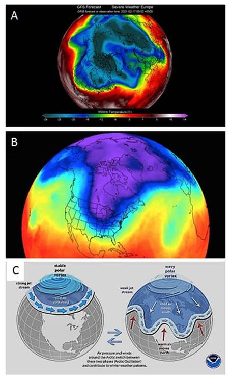
Figure 1. (A and B) Extensions from the Arctic polar zone into North America and Eutope; (C) weakening of the Arctic jet stream boundary (NOAA)

The weakening of the Arctic boundary is a part of the overall shift of climate zones toward the poles in both hemispheres, documented in detail in Europe (Figure 2). Transient cooling pauses are projected as a result of the flow of cold ice meltwater from Greenland and Antarctica into the oceans, leading to stadial cooling intervals.
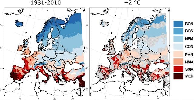
Figure 2. Migration of climate zones in Europe during 1981-2010 and under +2°C. Faint pink areas represent advanced warming. (A, left) Agro‐climate zonation of Europe based on growing season length (GSL) and active temperature sum (ATS) obtained as an ensemble median from five different climate model simulations during the baseline period (1981–2010). (B, right) Ensemble median spatial patterns of agro-climate zones migration under 2°C global surface warming according to model RCP8.5. Gray areas represent regions where no change with respect to the baseline period is simulated.

A combination of ice sheet melting and the flow of melt water into the oceans on the one hand, and ongoing warming of tropical continental zones on the other hand, are likely to lead to the following:

  • Storminess due to collisions of cold and warm air masses;
  • As the ice sheets continue to melt, the cold meltwater enhances lower temperatures at shallow ocean levels, as modelled by Hansen et al. (2016) and Bonselaer et al (2018) (Figure 3A), as contrasted with warming at deeper ocean levels over large parts of the oceans. This transiently counterbalances the effects of global warming over the continents arising from the greenhouse effect;
  • The above processes herald chaotic climate effects, in particular along continental margins and island chains.
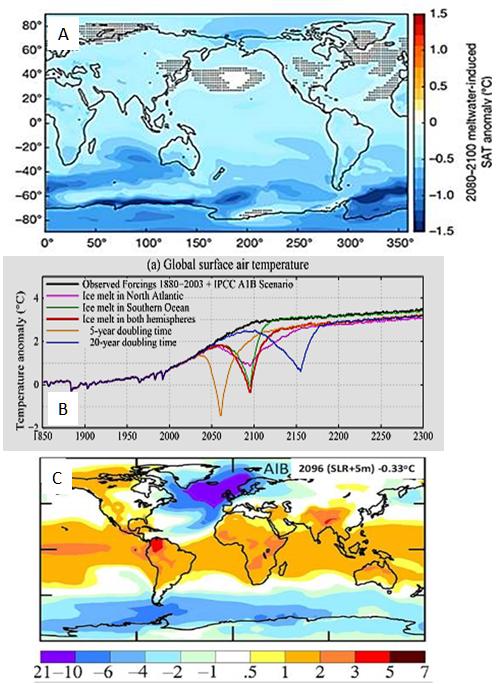
Figure 3. A. 2080–2100 meltwater-induced sea-air temperature anomalies relative to the standard RCP8.5 ensemble (Bronselaer et al., 2018), indicating marked cooling of parts of the southern oceans. Hatching indicates where the anomalies are not significant at the 95% level; B. Negative temperature anomalies through the 21st-22nd centuries signifying stadial cooling intervals (Hansen et al., 2016); C. A model of Global warming for 2096, where cold ice melt water occupies large parts of the North Atlantic and circum-Antarctica, raises sea level by about 5 meters and decreases global temperature by -0.33°C (Hansen et al., 2016).

The extreme rate at which the global warming and the shift of climate zones are taking place virtually within a period less than one generation-long, faster than major past warming events such as at the Paleocene-Eocene boundary 56 million years ago, renders the term “climate change” hardly appropriate, since what we are looking at is a sudden and abrupt event.

According to Giger (2021)

“Tipping points could fundamentally disrupt the planet and produce abrupt change in the climate. A mass methane release could put us on an irreversible path to full land-ice melt, causing sea levels to rise by up to 30 meters. We must take immediate action to reduce global warming and build resilience with these tipping points in mind.”

Computer modelling does not always capture the sensitivity, complexity and feedbacks of the atmosphere-ocean-land system as observed from paleoclimate studies. Many models portray gradual or linear responses of the atmosphere to compositional variations, overlooking self-amplifying effects and transient reversals associated with melting of the ice sheets and cooling of the oceans by the flow of ice melt.

According to Bonselaer et al. (2018)

“The climate metrics that we consider lead to substantially different future climate projections when accounting for the effects of meltwater from the Antarctic Ice Sheet. These differences have consequences for climate policy and should be taken into account in future IPCC reports, given recent observational evidence of increasing mass loss from Antarctica” and “However, the effect on climate is not included (by the IPCC) and will not be in the upcoming CMIP6 experimental design. Similarly, the effects of meltwater from the Greenland Ice Sheet have so far not been considered, and could lead to further changes in simulated future climate”. Depending on future warming the effect of Antarctic ice meltwater may extend further, possibly becoming global.

By contrast to ocean cooling, further to NASA’s reported mean land-ocean temperature rise of +1.18°C in March 2020 above pre-industrial temperatures, relative to the 1951-1980 baseline, large parts of the continents, including central Asia, west Africa eastern South America and Australia are warming toward mean temperatures of +2°C and higher. The contrast between cooling of extensive ocean regions and warming of the continental tropics is likely to lead to extreme storminess, in particular along continent-ocean interfaces.

The late 20th century to early 21st century global greenhouse gas levels and regional warming rates have reached a large factor to an order of magnitude faster than warming events of past geological and mass extinction events, with major implications for the nature and speed of extreme weather events.

For these reasons the term “climate change” for the current extreme warming, which is reaching +1.5°C over the continents and more than +3°C over the Arctic over a period shorter than one century, no longer applies.

The world is looking at an extremely rapid shift in the climatic conditions that have allowed civilization to emerge.

*

Note to readers: please click the share buttons above or below. Forward this article to your email lists. Crosspost on your blog site, internet forums. etc.

Dr Andrew Glikson is an Earth and Paleo-climate scientist, Canberra, Australia.

Featured image is from Barbara Nimri Aziz

Saturday, 2 February 2019

Restated: the connection between the polar vortex and global warming

How frigid polar vortex blasts are connected to global warming

by Jennifer Francis, Rutgers University

Arctic News,
1 February, 2019

File 20190128 39344 1rjndrb.jpg?ixlib=rb 1.1
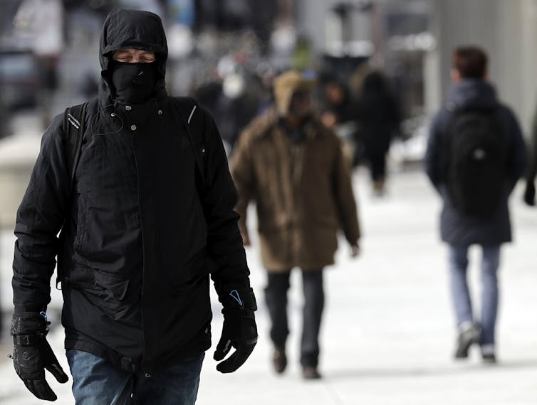
Bundled up against the cold in downtown Chicago, Sunday, Jan. 27, 2019.AP Photo/Nam Y. Huh

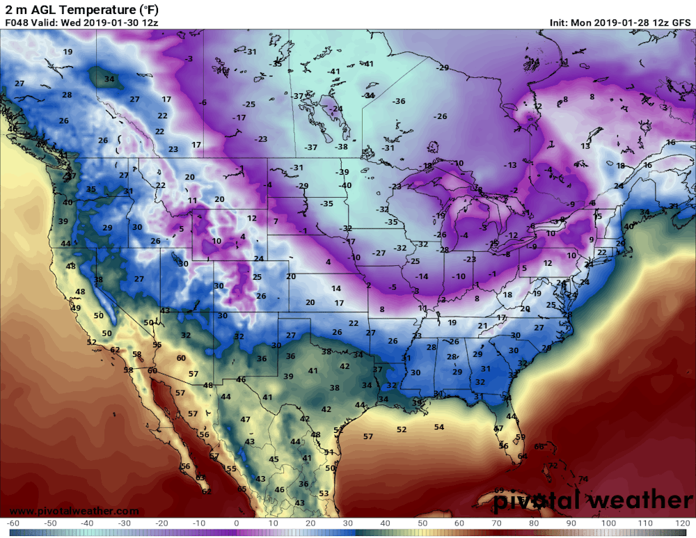
A record-breaking cold wave is sending literal shivers down the spines of millions of Americans. Temperatures across the upper Midwest are forecast to fall an astonishing 50 degrees Fahrenheit (28 degrees Celsius) below normal this week – as low as 35 degrees below zero. Pile a gusty wind on top, and the air will feel like -60 F.


Predicted near-surface air temperatures (F) for Wednesday morning, Jan. 30, 2019. Forecast by NOAA’s Global Forecast System model. Pivotal Weather, CC BY-ND

This cold is nothing to sneeze at. The National Weather Service is warning of brutal, life-threatening conditions. Frostbite will strike fast on any exposed skin. At the same time, the North Pole is facing a heat wave with temperatures approaching the freezing point – about 25 degrees Fahrenheit (14 C) above normal.


Predicted near-surface air temperature differences (C) from normal, relative to 1981-2010.

Pivotal Weather, CC BY-NDWhat is causing this topsy-turvy pattern? You guessed it: the polar vortex.

In the past several years, thanks to previous cold waves, the polar vortex has become entrenched in our everyday vocabulary and served as a butt of jokes for late-night TV hosts and 
politicians. But what is it really? Is it escaping from its usual Arctic haunts more often? And a question that looms large in my work: 

How does global warming fit into the story?

Jimmy Fallon examines the pros and cons of the polar vortex.

Rivers of air

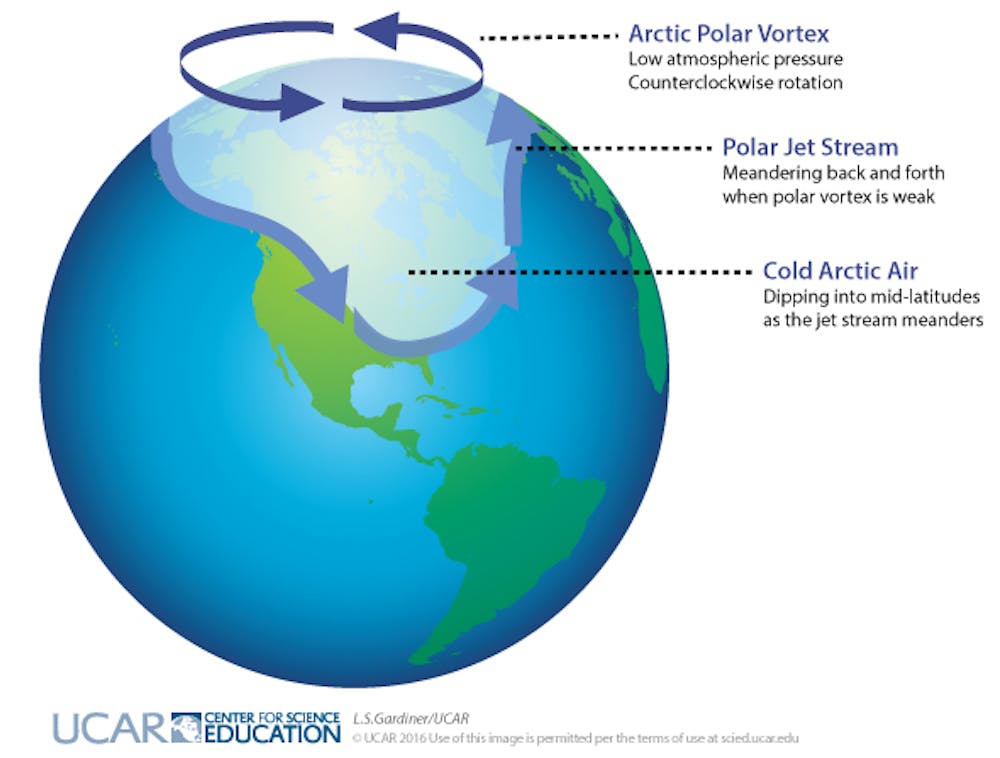
Actually, there are two polar vortices in the Northern Hemisphere, stacked on top of each other. The lower one is usually and more accurately called the 
jet stream. It’s a meandering river of strong westerly winds around the Northern Hemisphere, about seven miles above Earth’s surface, near the height where jets fly.

The jet stream exists all year, and is responsible for creating and steering the high- and low-pressure systems that bring us our day-to-day weather: storms and blue skies, warm and cold spells. Way above the jet stream, around 30 miles above the Earth, is the 
stratospheric polar vortex. This river of wind also rings the North Pole, but only forms during winter, and is usually fairly circular.

Dark arrows indicate rotation of the polar vortex in the Arctic; light arrows indicate the location of the polar jet stream when meanders form and cold, Arctic air dips down to mid-latitudes. L.S. Gardiner/UCAR, CC BY-ND

Both of these wind features exist because of the large temperature difference between the cold Arctic and warmer areas farther south, known as the mid-latitudes. Uneven heating creates pressure differences, and air flows from high-pressure to low-pressure areas, creating winds. The spinning Earth then turns winds to the right in the northern hemisphere, creating these belts of westerlies.

Why cold air plunges south

Greenhouse gas emissions from human activities have warmed the globe by about 1.8 degrees Fahrenheit (1 C) over the past 50 years. However, the Arctic has 
warmed more than twice as much. Amplified Arctic warming is due mainly to dramatic melting of ice and snow in recent decades, which exposes darker ocean and land surfaces that absorb a lot more of the sun’s heat. 

Because of rapid Arctic warming, the north/south temperature difference has diminished. This reduces pressure differences between the Arctic and mid-latitudes, weakening jet stream winds. And just as slow-moving rivers typically take a winding route, a slower-flowing jet stream tends to meander. 

Large north/south undulations in the jet stream generate wave energy in the atmosphere. If they are wavy and persistent enough, the energy can travel upward and disrupt the stratospheric polar vortex. Sometimes this upper vortex becomes so distorted that it splits into two or more swirling eddies. 

These “daughter” vortices tend to wander southward, bringing their very cold air with them and leaving behind a warmer-than-normal Arctic. One of these eddies will sit over North America this week, delivering bone-chilling temperatures to much of the nation.

Deep freezes in a warming world

Splits in the stratospheric polar vortex do happen naturally, but should we expect to see them more often thanks to climate change and rapid Arctic warming? It is possible that these cold intrusions could become 
a more regular winter story. This is a hot research topic and is by no means settled, but a handful of studies offer compelling evidence that the stratospheric polar vortex is changing, and that this trend can explain bouts of unusually cold winter weather.

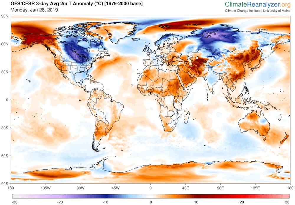
Undoubtedly this new polar vortex attack will unleash fresh claims that global warming is a hoax. But this ridiculous notion can be quickly dispelled with a look at predicted temperature departures around the globe for early this week. The lobe of cold air over North America is far outweighed by areas elsewhere in the United States and worldwide that are warmer than normal.


Predicted daily mean, near-surface temperature (C) differences from normal (relative to 1979-2000) for Jan. 28-30, 2019. Data from NOAA’s Global Forecast System model.

Climate Reanalyzer, Climate Change Institute, University of Maine., CC BY-ND
Symptoms of a changing climate are not always obvious or easy to understand, but their causes and future behaviors are increasingly coming into focus. And it’s clear that at times, coping with global warming means arming ourselves with extra scarfs, mittens and long underwear.


Jennifer Francis, Visiting Professor, Rutgers University

Sunday, 4 March 2018

An old argument over the jet stream has never been more relevant

Harking back to a controversy in mid-2016 one is left wondering if anything has changed since then. I am sure the modellers will be defending their disproved compute models until the bitter end. After all their paychecks depend on it.

Scientists warn of 'global climate emergency' over shifting jet stream

Other scientists have since dismissed the claims as 'total nonsense'

30 June, 2016

Two environmentalists have declared a “global climate emergency” after the Northern hemisphere jet stream was found to have crossed the equator, bringing “unprecedented” changes to the world’s weather patterns.

Robert Scribbler and University of Ottawa researcher Paul Beckwith warned of the “weather-destabilising and extreme weather-generating” consequences of the jet stream shift.
However other scientists dismissed their claims, with one describing their concern over wind crossing the equator as "total nonsense".

Scribbler and Beckwith said the anomalies were most likely precipitated by man-made climate change, which caused the jet stream to slow down and create larger waves.
Scribbler wrote in a post on his environmental blog on Tuesday: “It’s the very picture of weather-weirding due to climate change. Something that would absolutely not happen in a normal world. Something, that if it continues, basically threatens seasonal integrity.

The blogger explained the barrier between the two jet streams generates the strong divide between summer and winter, and the “death of winter” could commence if it is eroded as warm weather leaks into the “winter zone” of the year.
He continued: “As the poles have warmed due to human-forced climate change, the Hemispherical Jet Streams have moved out of the Middle Latitudes more and more. You get this weather-destabilising and extreme weather generating mixing of seasons.”


Meanwhile, Mr Beckwith confirmed the changes would usher in a sustained period of “climate system mayhem” which could prove difficult to resolve.

He said: “Our climate system behaviour continues to behave in new and scary ways that we have never anticipated, or seen before.
“Welcome to climate chaos. We must declare a global climate emergency.
“The behaviour of the jet stream suggests massive hits to the [global] food supply and the potential for massive geopolitical unrest. There’s very strange things going on on planet Earth right now.”
There are two forms of jet streams - polar and subtropical - and the northern and southern hemispheres have one of each.

The streams are the products of atmospheric heating by solar radiation and kept in place by the force of inertia

Tuesday, 27 February 2018

Paul Beckwith on the polar vortex and the jet stream

Jet Stream Love Affair with Stratospheric Polar Vortex


Human experience with weather is all within the lower atmosphere (troposphere). Above this is the stratosphere, where the protective ozone layer resides. Near the borderline (tropopause) jet streams (aka Rossby Waves or Tropospheric Polar Vortices) circumvent the planet, dividing cold dry polar air from hot moist equatorial derived air, and guiding storms. Much less well known is the Stratospheric Polar Vortex that crucially interacts with the jet streams affecting surface weather, and vice versa.