

Arctic Warmth to Play the Spoiler? Ocean Surface, Atmosphere Show Anomalous Heat Spike in Advance of Predicted El Nino
18
March, 2014
Pacific
Ocean monitoring stations around the world are now calling for a
50-67 percent chance of El Nino later
this year. A warming of the Eastern Pacific that, should it emerge,
is likely to result in record atmospheric and ocean temperatures as
the human greenhouse gas heat forcing emerges, once more, from the
oceans. But, so far, the Eastern Pacific remains in a somewhat cool
ENSO-neutral state. It is a trend that should lead to global
atmospheric temperature averages somewhat hotter than the ocean
surface. A trend that should not show ocean temperatures spiking,
with atmospheric values rising at a slower rate.
But
over the past week, according to both GFS model assessments and NOAA
observational data, average global ocean surface temperatures have
been surging.
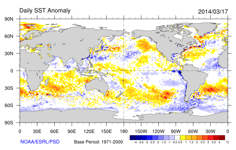
(Sea
surface temperature anomaly from the already warmer than normal 1971
to 2000 base period. Image source: NOAA.)
Large
zones of well above average sea surface temperature now cover vast
regions of the global ocean system so that anomalous heat now is
plainly the dominant feature. Pools of hotter than typical water
where averages range from 1 to 4 C above normal now appear off both
coasts of South America, through the Indian Ocean between Africa and
Australia, off the East Coast of the United States, south of Alaska
and in a zone stretching from Norway to Svalbard. By contrast only
small cool zones remain in the Eastern Pacific, in the passage
between South America and Antarctica, in a swatch of the Tropical
Atlantic near Africa, and in isolated regions of the Central and
Western Pacific.
Arctic
Warmth Drives Temperatures Higher
But
the zone of hottest temperatures appear, according to GFS model data
below, in the Arctic, where much of the surface waters and ice sheet
are warmer than average by 4 C or more. This heat bleed from the
Arctic Ocean tips Northern Hemisphere values far above average and is
a primary contributor to Arctic atmospheric temperatures in the range
of 3-4 C above average (1979-2000) for mid to late March.
During
the past few days, the effect of this warm surface was enough to
drive temperature anomalies for the oceans higher than .9 degrees
Celsius above the 1979 to 2000 global average according to GFS
observational data. Understanding that the 1979 to 2000 global sea
surface temperature (SST) average was already about .28 C above the
1880s average,we
are now seeing SST daily values in excess of 1.18 C above 1880s
averages before El Nino comes into play.
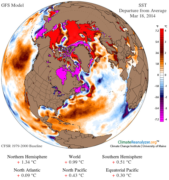
(Sea
surface temperature anomaly for March 18, 2014 vs the, already warmer
than normal, 1979-2000 average. Image source: University
of Maine.)
Even
more impressive are the sea surface temperature values seen during
the past two days (March 17-18) — hitting a .99 C positive anomaly
or +1.27 C above 1880s values.
For
comparison, the global sea surface temperature average for 2013,
according to the National
Climate Data Center,
was .42 degrees Celsius above the 1880s average and the hottest year
for ocean surface temperatures, 2003, was .52 degrees Celsius hotter
than the 1880s average. The average for the past two days, should the
GFS observation stand, is +.75 above the highest annual average on
record.
Daily
values for even the entire ocean system can show rather large swings,
but this high temperature trend is somewhat new and has been ongoing
now for about a week.
Oceans
dumping heat into the atmosphere without El Nino
By
contrast, global atmospheric temperatures within the first two
meters, according to the same GFS data, are, on March 18, .69 C above
the 1979-2000 average. It is a reading .3 C below current sea surface
temperature values. Yet it is also a reading about 1 C over 1880s
values and about .3 C above annual global high temperature records
set in 2010.
With
ocean surface temperatures higher than 2 meter air temperatures, it
appears the ocean is now dumping some of its latent heat back into
the atmosphere through radiative transfer. This is a situation
opposite of what has been observed for much of the past 13-14 years
running when Pacific Decadal Oscillation (PDO) went negative and the
oceans underwent rapid warming as they sucked up atmospheric heat.
What
we now observe in the preliminary GFS data is evidence that the ocean
is dumping a bit of this stored and massive volume of heat back into
the atmosphere. And we are seeing significant positive oceanic and
atmospheric heat forcing well before any major level of Eastern
Pacific Ocean warming and associated El Nino have come into play.
Links:
No comments:
Post a Comment
Note: only a member of this blog may post a comment.