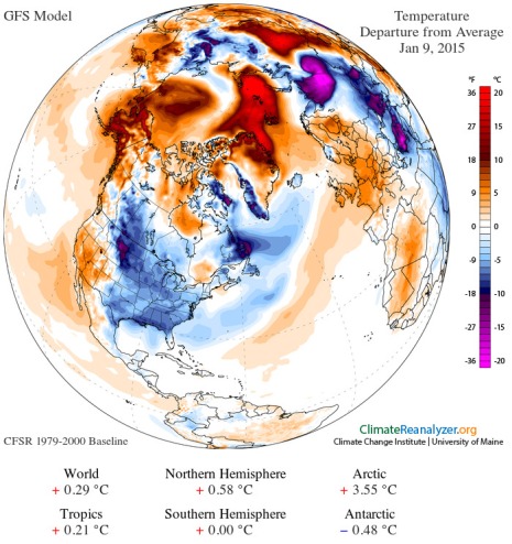
(Polar Amplification on Friday January 9, 2014 plainly visible in the GFS summary. Another warmer than average day for the Arctic in a warming world. Image source:Climate Reanalyzer.)
For
the Arctic, it’s another much warmer than normal day…
Temperature
anomalies for the region spiked to 3.55 degrees Celsius above the,
already hotter than normal, 1979-2000 average. And a swath of the
Arctic Ocean stretching from Greenland to Siberia experienced
extraordinary 15-22 C above average temperatures.
It’s
another day of Arctic Amplification — the fourth in an ongoing
progression this week. Another day of extreme dipole temperature
anomalies. And another day of record-setting weather. All symptoms,
plain as day, of a world undergoing a fit of rapid, human-induced
heating.
Warmth
in The High Arctic Drives the Cold Out
Last
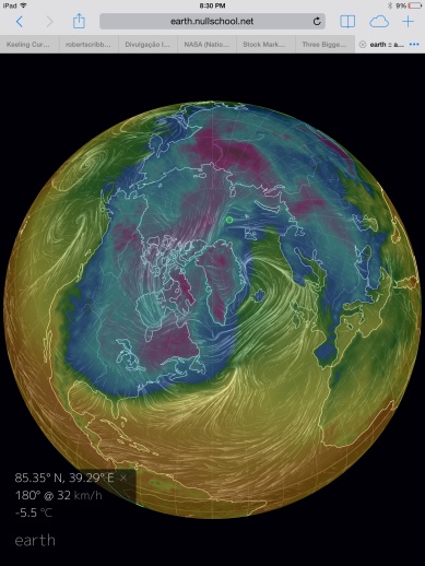
night, while studying Earth Nullschool, I found a temperature of 27 F
near Zemlya — an Island in the Arctic Ocean off Siberia. The night
before last, I captured these two pictures — one of a region a few
hundred miles south of the North Pole and well north of Svalbard at
22 F and another of the surface temperature near Richmond, Virginia
at 20 F.
In
other words, it was warmer just off Santa’s front porch than it was
thousands of miles to the south in Richmond, VA.
In
technical meteorological parlance there’s a term for such warm
north, cold south temperature variations — dipole. In this case,
it’s a cold North American Continent and a warm Atlantic Ocean
pushing much higher than average temperatures far into the Arctic.
Jet
Stream Re-Mangled — High Amplitude Jet Stream Waves
Such
a warm airs surging north forcing cold airs south arrangement can
result in some pretty extreme waviness in the Jet Stream. The kind of
waviness that Dr. Jennifer Francis has warned is set off by just the
kind of Arctic warming we witnessed this week.
And,
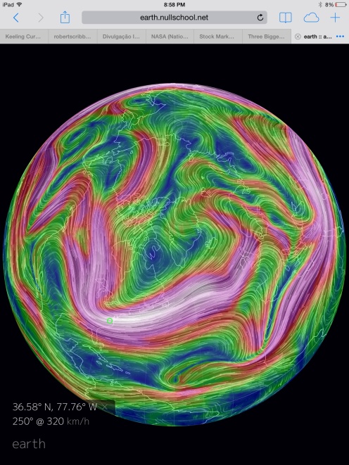
as we can plainly see in the map below, we have an extraordinary
meridional pattern in the Jet Stream occurring in perfect
coordination with the current instance of polar heating:
I
suppose some may call this kind of instance circumstantial. But what
a circumstance, especially when one considers the plainly obvious and
visible mechanism of the current polar temperature spike, the
subsequent southward displacement of warm air from the polar zone,
and the related warm air invasion flooding up from the North Atlantic
into the heat compromised polar core.
It’s
as easy to see as 1,2,3.
This
re-arranging of air masses has re-instated the kind of circulation
pattern around Greenland we warned about during late November of
2014. A kind of off-center displacement of air masses that shoves
cold toward hot and can result in some rather extreme weather.
Record-Setting
Winds over Scotland Last Night
Dr.
Francis has also mentioned this resulting heightened severe weather
potential in her research. And she can count herself among such
visionaries as Dr. James Hansen who warned of ramping storm intensity
resulting from a combined polar amplification and melting and
softening of the remaining great glaciers in Greenland and, later,
Antarctica.
Unfortunately,
the more recent polar amplification episode did set off a spate of
rather extreme weather in Scotland. The North Atlantic storm track
intensified as temperature differentials ramped up. On Tuesday, a 930
mb low bombed out between Greenland and Iceland. Fed by a massive
meridional air-flow, this storm soon generated very strong winds
raging across the North Atlantic.
By
last night, these winds roared throughout Scotland, peaking at 113
miles per hour — a new all-time record for the Northern Isles since
wind measures began in 1970.
In
a return to the kind of extreme weather that battered the UK for much
of the winter of 2013-2014, trees were torn down, power lines
unmoored and roads and railways blocked. This, in turn, forced a
wide-scale emergency response throughout Scotland after last night’s
brutal battering by hurricane force winds.
From the BBC:
The
storm caused the suspension of all ScotRail trains, although some
limited services are now running. More than
46,000 homes are currently without power as the Atlantic jet stream
caused gusts of more 100mph(160km/h).
So
the observational evidence is pretty clear. Here we have yet another
instance where polar heating is driving some rather extreme Jet
Stream changes coupled with related instances of record extreme
weather. And as human-related warming continues to intensify, we are
likely to see far worse instances than today’s minor episode.
Links:
Scientific
Hat Tip to Dr. Jennifer Francis and James Hansen
Hat
Tip to commenters JPL and DTLange
Alarm
over Kara Sea
permafrost thawing
Remember
the big sinkhole on Yamal Peninsula discovered last summer?
Scientists have now discovered leaking methane gas from the shelf
west of Yamal. That is where Gazprom will drill
Kara Sea with Beloye Ostrov north of the Yamal Peninsula. (Photo: Thomas Nilsen)
9
January, 2015
“If
the temperature of the oceans increases by two degrees as suggested
in some reports, it will accelerate the thawing to the extreme. A
warming climate could lead to an explosive gas release from the
shallow areas,” says PhD Alexei Portnov at Centre for Arctic Gas
Hydrrate, Climate and Environment (CAGE) with the Arctic University
of Norway in Tromsø.
Not
far from the shores of the Yamal Peninsula is Gazprom planning for
extensive drilling for more natural gas. Both the Leningradskoye- and
Rusanovskoye fields are on the Western shelf of Yamal in the Kara
Sea. In total, Gazprom plans to develop
20 offshore fields in
the Kara Sea.
Portnov
and his colleagues have recently published
the results from
studies done on the seafloor of the Kara Sea in the Russian Arctic.
The results are scary reading: The West Yamal shelf is leaking at
depths much shallower than previously believed.
Researcher
PhD Alexei Portnov. (Photo: CAGE)
“Significant
amount of gas is leaking at depths between 20 and 50 meters,” the
paper reads.
“Terrestrial
Arctic is always frozen, average ground temperatures are low in
Siberia which maintains permafrost down to 600-800 meters ground
depth. But the ocean is another matter. Bottom water temperature is
usually close to or above zero. Theoretically, therefore, we could
never have thick permafrost under the sea,” says Portnov “However,
20 000 years ago, during the last glacial maximum, the sea level
dropped to minus 120 meters. It means that today´s shallow shelf
area was land. It was Siberia. And Siberia was frozen. The permafrost
on the ocean floor today was established in that period,”
says Portnov.
It
is the permafrost that keeps the methane gas in the sediments. With
warmer climate and warmer water in Arctic Oceans the permafrost layer
is melting. It is also the permafrost under the seabed that
stabilizes gas hydrates, ice-structures that usually need high
pressure and low temperatures to form.
“Gas
hydrates normally form in water depths over 300 meters, because they
depend on high pressure. But under permafrost the gas hydrate may
stay stable even where the pressure is not that high, because of the
constantly low temperatures,” explains Alexei Portnov.
Gas
hydrates contain huge amount of methane gas. It is destabilization of
these that is believed to have caused the huge sinkholes that
appeared as out of nowhere on the Yamal Peninsula last summer.
The
study has discovered that gas is released in an area of at least
7,500 m2, with gas flares extending up to 25 meters in the
water column.
With
a warmer climate, more permafrost will melt, and more methane gas
will leak out. The fear is a “point of no return” where leakages
of methane will continue to warm the climate even if all human-caused
releases are stopped.
Methane
is a potent greenhouse gas, 28 times more powerful than CO2.
Under,
you can see a video where scientits are climbing into the mysterious
crater on the Yamal Peninsula.


No comments:
Post a Comment
Note: only a member of this blog may post a comment.