Death Valley Like Heat Predicted to Blanket the Southwest By Next Week
14
June, 2016
Drought
is again expanding over the US West.
Oregon, after a very rapid April and May snowmelt, is
being advised to conserve water.
And with high pressure building in over the Southwest, weather models
are predicting the emergence of an extreme heatwave by late this
weekend. One that current guidance is indicating will bring 100 to
120 degree (F) temperatures to a wide region stretching from
California’s Central Valley, through Southern California,
Northwestern Mexico, Arizona, Nevada and into Southern Utah.
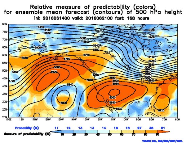
(The
US is expected to swelter under a heat dome that is predicted to form
this weekend and expand on into next week. Record heat is predicted
to first impact the US Southwest before building into the Central US
by late next week. Image source: NCEP/NOAA.)
The
trigger for what may become a record-shattering heatwave is the
predicted development of a powerful atmospheric ridge. Model guidance
now shows a strong high pressure system currently over the
Northeastern Pacific extending its influence eastward over the coming
days. By the middle of next week, most of the US is predicted to fall
under the atmospheric sway of a big bully of a high pressure system
centered over the Southwestern States. Spiking atmospheric pressures
and clear skies are expected to then usher in record temperatures for
much of the US Southwest.
For
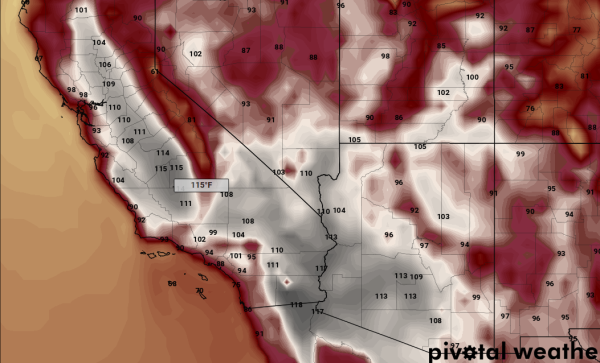
parts of California’s Central Valley near Fresno, temperatures
could rise as high as 116 F by Wednesday of next week (June 21).
That’s about 23 degrees (F) above average for this time of year
and would
beat the hottest reading ever recorded in any month for the city.
The same day prediction for Sacramento is in the range of 110 F — a
little shy of the all-time record, but a reading that would shatter
the June 21 daily record by a good margin.
110
degree + readings are expected to blanket Southeastern California,
Sections of Northwestern Mexico, Southwestern Arizona, and
Southeastern Nevada. Near 100 degree readings are expected to extend
as far north as Redding, California. In other words, a huge section
of the Southwestern US is expected to experience Death Valley like
weather conditions.
(Record
heat is predicted to blanket most of the Southwest US by next week.
This graphic shows predicted peak daily temperatures on Wednesday,
June 21. Image source: Pivotal
Weather.)
This
kind of record heatwave is something one might have expected during
an extreme year of the 20th Century in July. But what we’re seeing
is its potential to emerge now in mid-to-late June. An indication
that record global atmospheric temperatures are starting to have some
rather serious regional impacts along the lines predicted by various
Global Circulation Models. These models indicated a particular
vulnerability of the US Southwest to extreme heat and drying under
the atmospheric forces set off by human fossil fuel burning. And this
predicted heatwave is building up in an atmospheric context in which
global temperatures will likely be around 1.2 C hotter than 1880s
averages during 2016.
In
this context, the potentially building record heatwave threatens to
greatly expand and reassert drought conditions in the US Southwest
this Summer. Should it emerge as models are currently predicting, it
will greatly increase soil moisture evaporation and remaining
snowpack melt across the region — amplifying drought conditions in
over a region where many had hoped a strong El Nino would stave off
these kinds of climate change related impacts for at least another
few years. And for these reasons along with the direct risks of heat
injury to human beings, interests should closely monitor its
development.
Links:
Hat
tip to DT Lange
Hat
tip to Colorado Bob


No comments:
Post a Comment
Note: only a member of this blog may post a comment.