This is What A Fossil Fuel Dystopia Looks Like — The Arctic Sea Ice is Breaking Up North of Greenland in June
23
June, 2016
The
Arctic sea ice is breaking up to the north of Greenland during June.
It’s the
fossil fuel burning global dystopia phrase
of the day. Another cognitive dissonance producing instance of
something that would have never happened without the added heat kick
provided by human-forced climate change. But now, with atmospheric
CO2 topping out at near 408 ppm during May of this year, it appears
that all sorts of weather weirdness is currently possible.
(1-3
mile wide cracks appear in the sea ice north of Greenland in this
NASA satellite shot on June 19 of 2016. For reference, bottom edge of
frame is 400 miles. Image source: LANCE
MODIS.)
It
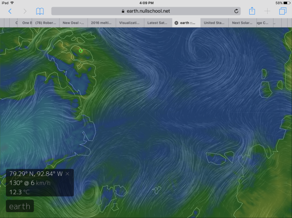
was an odd break-up spurred by the onrush of warm winds rising up
from Continental North America. These winds of climate change fueled
record temperatures as they crossed the northern islands of the
Canadian Archipelago over the past week. On Axel Heiburg Island,
temperatures hit near 54 degrees F (12.3 C) along the 80 degree North
Latitude line. Readings that are about 15-20 degrees F (7 to 12 C)
above average for this time of year and highly anomalous readings for
what should be a permanently frozen island.
These
southerly winds then bore the record warm to near record warm airs
across a region just north of Greenland — pushing temperatures over
this section of the Arctic Ocean into the mid to upper 30s. This
extra heat was then enough to shatter the thinning ice. 1-3 Mile wide
cracks opened up as the ice drifted off its moorings between Northern
Greenland and the North Pole.
(Warm,
moist winds flowing over the Canadian Archipelago and into the Arctic
Ocean on June 15-18 set up conditions that shattered sea ice to the
North of Greenland. Image capture at 00:00 UTC on June 18 by Earth
Nullschool.)
Now,
the entire Arctic Ocean ice pack from the Beaufort to the East
Siberian Sea, to the Laptev, across the Kara and north of the Barents
on to north of Greenland and the Canadian Archipelago is floating
free in June. A condition that was unheard of in August or September
just a decade and a half ago, but one that is now occurring before
the Summer Solstice.
Overall,
for this time of year, Arctic sea ice extent remains in or near
record low ranges despite weather conditions that would have
traditionally helped to preserve sea ice. Storms over the central ice
have provided cloudy conditions, preventing direct sunlight from
hitting the ice and speeding melt. However, despite these conditions,
temperatures over most of the Arctic have remained above average —
with some regions along the coast experiencing substantially above
average temperatures.
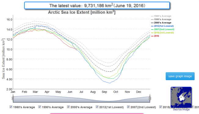
(Arctic
sea ice extent continues in record low ranges on June 19 of 2016
according to JAXA’s
sea ice monitor.)
After
record Arctic warmth this Winter and Spring, storms churning over the
sea ice during June have done little to prevent continued record low
extents throughout the Northern Polar zone or to disallow strange
events like the early-season break-up of ice to the north of
Greenland. To the contrary, we have numerous instances where storms
are drawing in warm, wet winds from the south and are increasingly
dumping rainfall over the sea ice. A condition that also tends to
speed melt.
By
yesterday, Japan’s sea ice measure (JAXA) had dropped to 9,730,000
square kilometers or about three days ahead of record melt year
2012’s all time low line. Rates of loss steepened over recent days
as the anomalous Arctic heat bit in and numerous shattered ice flows
lost integrity under relentless elemental punishment.
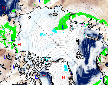
(Rainstorms
over Arctic sea ice, like this one which is predicted to form by
Tuesday in the GFS Model, can be even more damaging to ice coverage
than direct sunlight. High amplitude Jet Stream waves often deliver
these storms — born upon warm, wet winds — to the Arctic during
summers that have now been dramatically warmed by human fossil fuel
emissions. Image source: Climate
Reanalyzer GFS
capture for 00:00 UTC Tuesday June 21.)
Record
low sea ice extents for 2016 are likely to continue to have an
influence on Northern Hemisphere weather — assisting the formation
of high amplitude Jet Stream wave patterns. These waves are
associated with extreme and persistent weather conditions to include
— heatwaves, droughts, wildfires and floods. One such wave pattern
is now facilitating record hot temperatures and increased wildfire
hazards over the US West and has the potential to set off heatwaves
over the Alaskan and Canadian Arctic even as anomalous rainstorms
form over wide sections of the Arctic Ocean during the next couple of
weeks.
Links:
Hat
tip to Cate
Hat
tip to DT Lange


No comments:
Post a Comment
Note: only a member of this blog may post a comment.