Bad Rains Fall Across Globe — 700,000 Evacuated in Kyushu Deluge as Worst Flood in 100 Years Inundates West Virginia
24
June, 2016
In Kyushu, Japan on Friday, government officials urged 700,000 residents to evacuate as record heavy rains and severe flooding inundated the city for the fifth day in a row. Half a world away in West Virginia, another unpredicted record deluge dumped 8.2 inches of rain, washed out roads, cut off shopping malls, flushed burning homes down raging rivers, and left more than 14 people dead and hundreds more stranded.
Individually,
these events would be odd. But taken together with what are now
scores of other extreme flooding events happening around the world in
the space of just a few months and the context begins to look a lot
like what scientists expected to happen due to human-forced climate
change.
700,000
Urged to Evacuate in Kyushu Deluge
(Heavy
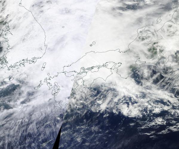
rains fall over Kyushu on Friday in the most recent wave of extreme
storms to blanket the island. Image source: LANCE
MODIS.)
In
Kyushu, the skies opened up on Monday. An extension of a seasonal
front draped across China and feeding on moisture bleeding off of
record hot ocean surfaces edged out over Japan. Mountainous cloud
banks unloaded. Record rains in the range of five inches an hour then
began to inundate the southern Japanese island. This mass dumping of
water eventually
accumulated to half a meter (or 1.6 feet) over some sections of the
island over the course of just one 24 hour period.
The
rains set loose raging rivers of water through Kyushu streets and
saturated hillsides already weakened by an April earthquake. The
flooding and resulting landslides killed 6 people on Monday alone and
resulted in calls for tens of thousands of people to evacuate the
hardest hit areas. Over the week, hourly rainfall totals of 1-3
inches and daily rainfall rates of 4-8 inches continued as more and
more of the region succumbed to flooding. By Friday, bridges and
roads had been washed out, an elderly man, a university student, and
a child had gone missing, trains had been blocked by mudslides and
the evacuation calls extended to include 700,000 people.
Unexpected
Record Floods Hit West Virginia
By
early Wednesday in West Virginia the weather was starting to get a
little rough. Strong storms had been running over the region since
Tuesday as an unstable air mass funneled lines of thunderstorms into
the Appalachian Mountain region. The forecast did indicate some
potential for severe weather, but nothing near so extreme as what
emerged.
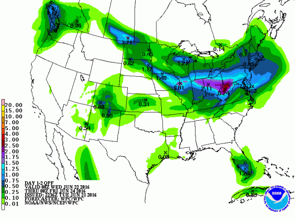
NOAA
QPC predictions
called for peak rainfall amounts in the range of 3.24 inches from
Wednesday through Friday. But the inundation that occurred on just
Thursday alone resulted in rainfall totals of more than two and a
half times that:
(In
another instance that calls into question whether current forecast
models are keeping up with the heavy rainfall potentials that are now
made possible by a record hot global atmosphere NOAA’s predicted
rainfall totals are again greatly exceeded by events — this time in
West Virginia where 14 people have been reported dead due to
flooding. An indication that weather prediction may not be fully
taking into account the added threat posed by human-forced warming.
And also an indication that endemic climate change denial in the US
political system [in vast majority among republicans] — which
has resulted in a dramatic failure to fund needed and necessary
climate change monitoring —
is having a harmful overall impact to public safety and disaster
preparedness. Image source: NOAA
QPC.)
Reports
indicate that 8.17
inches of rain fell in just one 24 hour period in Sulfur Springs,
West Virginia.
But it was just the center mass of the worst flood in a century for
parts of the state. One that has so far resulted
in the deaths of more than fourteen people.
Five hundred people are also currently stranded in a shopping mall
that has now been cut off by the flood.
(A
burning home floats down a West Virginia creek swollen to a raging
torrent by the worst flood to hit the state in 100 years.)
Numerous
homes and hundreds of cars have also been lost due to the flash
floods that swept through West Virginia’s valleys. In one instance,
a burning house was filmed floating down a river. As a result of the
severe and unexpected rains, 44 of the state’s 55 counties have now
been declared a disaster area.
Conditions
in Context — Global Warming Fuels More Extreme Rainfall Events
These
severe flooding events add to those this week occurring in
China, Australia, Sri
Lanka,Indonesia,
and Great Britian over just the past seven days. In addition, extreme
floods have swept through Texas, Canada, Central Asia,
Europe, Ghana and
Argentina over the past couple of months.
The
floods occur at a time when global temperatures are just coming off
of new record highs during the first part of 2016. Temperatures that,
in February peaked near 1.5 degrees Celsius hotter than 1880s
averages. For each 1 degree Celsius that you add to global
temperature, you increase the atmospheric moisture loading by about 7
percent. This is a physical fact of the Earth’s climate system. If
you heat the atmosphere, you increase evaporation and that results,
in turn, in more moisture held up in the world’s airs.
It’s
this well understood dynamic of atmospheric physics that scientists
have long warned would result in more extreme droughts and downpours
as a result a human-forced warming of the world. Chris Fields, a
climate scientist cited by US
News and World Report in
an article covering the record Paris floods earlier this month also
noted:
“One of the clearest signs of climate change, over much of the world, is the increase in the fraction of the rain that falls in the heaviest events.”
So
not only does a loading up of the hydrological cycle with moisture
result in heavier rainfall events generally, it also results in a
greater fraction of overall rainfall coming in the form of heavy
rain. In other words climate change causes heavier rain on top of
heavier rain. The worst events, as a result do not just get worse,
they get much, much worse. And this is due to the added convection —
or updrafts — that keep moisture in the air longer. In other words,
the rain in a hotter world needs to be heavier to fall out of clouds
that are pushed higher and with greater force by heat rising up off
the Earth’s surface.
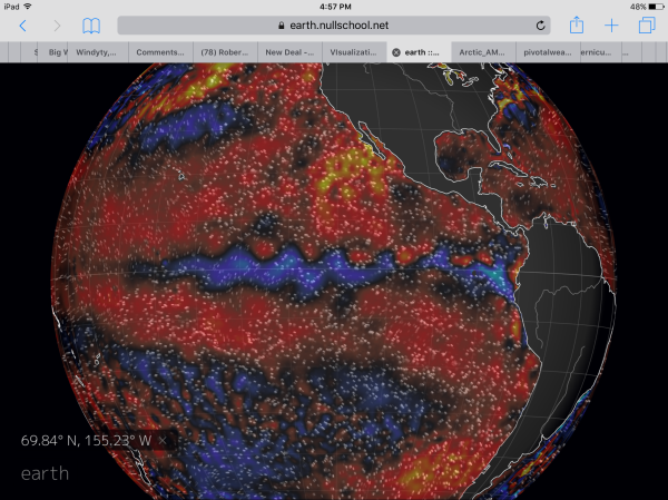
(In
a record-warm world, a transition from El Nino to La Nina can result
in an unprecedented amount of moisture being wrung out into trough
and storm zones. Extraordinarily heavy rainfall events like those
experienced across the world over the past few months is the
all-too-likely result. It’s a feature that has been added by global
temperatures that are now about 1.2 C hotter than 1880s in the annual
average. As global temperatures increase, heavy precipitation events
will continue to grow more intense even as droughts in other regions
worsen. Image source: Earth
Nullschool.)
As
for the timing of the most recent heavy rainfall events — the last
element to the equation has been a transition from El Nino to La
Nina. During the most recent El Nino, the Equatorial Pacific warmed
and new record global temperatures were achieved. But as the
Equatorial Pacific cooled, so did the atmosphere. And now, some of
that record atmospheric moisture load isn’t recieving quite as much
heat from beneath keeping it all aloft. So a greater portion of it
tends to fall out in the post El Nino period.
And
none of this is to say at all that El Nino is causing the increased
rate of flooding. The El Nino to La Nina transiton is a natural
variability based event that is instead being influenced by
human-forced warming in such a way that is resulting in an
increasingly extreme period of rainfall. And we’re experiencing
that globally now.
Links:
NOAA (please
support funding for public climate change monitoring)
Hat
tip to Greg
Hat
tip to Colorado Bob
Hat
tip to Climate Hawk


No comments:
Post a Comment
Note: only a member of this blog may post a comment.