

“This week’s predicted ridge formation is not expected to bring with it a severe surface melt of Greenland. However, the clockwise winds driving sea ice transport may serve as yet one more heavy blow to the already greatly weakened ocean ice.”
Siberian Heatwave Wrecks Sea Ice as Greenland High Settles In
3
June, 2016
We’ve
never seen Arctic sea ice extents that are as low as they are now in
early June. And with Arctic heatwaves, warm winds, warm storms, and a
Greenland High all settling in, something had better change soon or
otherwise the ice cap over the northern Polar Ocean is basically
screwed.
*****
On
the shores of the Arctic Ocean’s East Siberian Sea (ESS), near the
town of Logashinko, temperatures today are expected to rise to near
80 degrees Fahrenheit. Readings that are about 40 to 50 degrees (F)
above normal for this near-polar region during this time of year.

(Welcome
to increasingly ludicrous climates. Temperatures near 80 F at
Logashinko, Russia are at least 40 degrees F above average for this
time of year. A place well north of the Arctic Circle, but whose
temperatures are predicted today to match those of St. Martin Island
in the tropics. Image source: Earth
Nullschool.)
We
would have never expected temperatures to have risen so high near
typically frozen Logashinko during early June sans the heating effect
of atmospheric CO2 levels that have this year peaked near 407.5 parts
per million. The highest levels seen on Earth in about 15 million
years. These scorching polar temperatures were driven north by a
powerful high amplitude ridge in the Jet Stream that has dominated
Eastern Russia for much of 2016 Spring. This expansive ridge enabled
extreme wildfires popping up all over the region even as it today
drives 80 degree weather all the way to Arctic Ocean shores —
enforcing a regime of rapid sea ice melt over the East Siberian Sea.
ESS,
Laptev Get Ripped Up
As
the warm winds drive northward across ice-clogged Arctic Ocean
waters, temperatures rapidly fall into 35 to 41 degree (F) ranges.
And though that may sound cool to the casual observer, for the East
Siberian Sea zone during early June, that’s scorching hot —
topping out at more than 10 degrees above average for some areas. A
pretty extreme variation for late Spring when temperatures over the
Arctic Ocean only typically depart from average by about 3 or 4
degrees at most.

(The
Laptev and East Siberian Sea Ice is getting ripped up by extreme
Arctic warmth. The blue tint to ice in the above image indicates melt
ponds, while dark blue indicates open water. Zooming in closer
reveals the brown flush of warm waters issuing from heated Siberian
rivers. Image source: LANCE
MODIS.)
All
across this Arctic Ocean region, melt ponds and widening polynyas now
abound in the ridiculously warm airs. In the satellite shot above,
the tell-tale bluish tint of the ice reveals a plethora of these
ponds expanding northward through the ESS and on toward the pole. A
flush of hot water running into the Arctic Ocean from East Siberia’s
rivers is melting the near shore ice. And a giant 80 mile wide gap of
open water has now been torn into the ice of the Laptev Sea.
Record
Extent Lows Continue to Worsen
The
sudden Arctic heatwave and rapid related melt involvement of the ESS
and Laptev regions of the Arctic Ocean is just the most recent melt
spike in an Arctic Ocean that sees extent levels hitting new record
lows with each passing day. As of June 2nd, the expanse of Arctic Sea
ice only measured 10.37 million square kilometers. This is about
430,000 square kilometers below the previous daily record low set
just last year and fully ten days ahead of the record sea ice melt
year of 2012.
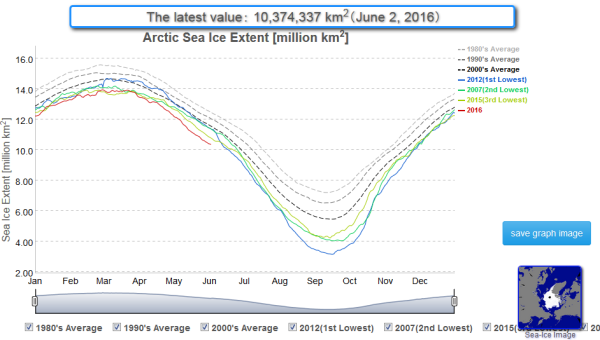
(Arctic
sea ice extent record lows continue for this time of year and
threaten to plunge deeply below the 2012 line in coming days. Image
source: JAXA.)
A
coverage of sea ice that is now 42 days and 2.1 million square
kilometers of sea ice loss ahead of an average melt year during the
1980s.
Here
Comes the Greenland High
Extreme
heat building into the Siberian side of the Arctic and record low sea
ice extent measures are today being joined by yet another disturbing
Arctic feature. For as of yesterday, a strong ridge of high pressure
began to form over Greenland, the Canadian Archipelago and Iceland.
Greenland
highs tend to increase temperatures over the enormous glaciers of
that frozen island even as the clockwise circulation pattern of an
anticyclone tends to shove sea ice out into the Barents and North
Atlantic. The dominance of a Greenland High during both 2012 and 2007
is thought to have heavily influenced record end season sea ice melts
during those years as well as the extreme Greenland surface melt
spike during 2012.

(A
high pressure ridge emerging over Greenland, Iceland and the Canadian
Archipelago today is expected to strengthen this week — generating
a high pressure gradient between warm storms developing over the
Arctic Ocean and winds that threaten to increase the rate of ice
transport out of the High Arctic and into regions of warmer water.
Image source: Earth
Nullschool.)
This
week’s predicted ridge formation is not expected to bring with it a
severe surface melt of Greenland. However, the clockwise winds
driving sea ice transport may serve as yet one more heavy blow to the
already greatly weakened ocean ice. Pressures later this week are
expected to rise to 1040 mb over Greenland. And strong winds running
between powerful warm storms expected to form in the Kara and Central
Arctic are predicted to rise to near gale force north of Greenland —
generating a risk of a very vigorous ice loss from the near polar
zone as floes are driven into warm Barents and North Atlantic waters.
In
context, the combined severe record sea ice lows and emerging weather
conditions represent a seriously bad state for Arctic sea ice. One
with a high risk of continued further extreme losses and new daily
record lows for at least the next seven days.
Links:
Hat
tip to Greg
Hat
tip to Cate
Hat
tip to DT Lange
No comments:
Post a Comment
Note: only a member of this blog may post a comment.