

Major Arctic Warming Event Predicted For the Coming Week
30
April, 2018
It’s
been consistently, abnormally, warm in the Arctic for about as long
as any of us can remember. But during recent years, the changes —
caused by a massive and ongoing accumulation of heat-trapping gasses
in the Earth’s atmosphere — appear to be speeding up.
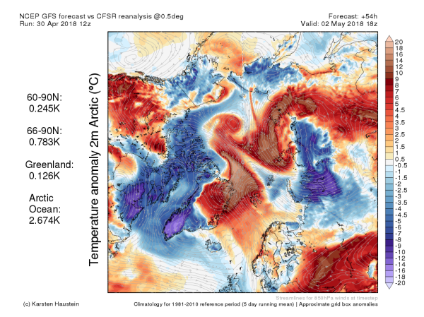
(Far
above normal temperatures are expected to invade the Arctic this
week. The likely result will be an acceleration of sea ice melt and
retreat. Image source: Global
and Regional Climate Anomalies.)
This
week, two major warm air invasions — one issuing from Siberia and
another rising up through the Fram Strait and extending north of
Greenland are expected to bring locally 10-20 C above normal
temperatures and accelerate early season sea ice melt in an already
reeling Arctic.
Consistent
Warmth, Record Low Sea Ice
The
farthest north region of our world has just come out of a winter
during which sea
ice extents consistently entered never before seen daily low ranges.
With the advent of spring, sea ice measures have rebounded somewhat
from winter record lows. However, according
to Japan’s Polar Research Division,
we are presently experiencing the second lowest daily sea ice extents
since consistent measurements began. Meanwhile, Greenland
during April saw an odd early bump in surface melt.
Overall,
the pattern has been one of consistent abnormal warmth. And over the
coming week, a number of warm air invasions will infringe upon the
typically cold early May Arctic — testing new boundaries yet again.

(An
ice-free Bering Sea, open water invading the Chukchi, and fractured
sea ice over the Beaufort are notable features for melt season start
during May of 2018. Image source: NASA.)
Much
of the heating action this year has occurred over the Bering and
Chukchi seas — which
have never seen so much ice lost.
Already sea ice is greatly reduced through these regions. Open water
extends far into the Chukchi — onward and north of Barrow, Alaska.
Still further into regions in which sea ice is typically rock-solid
during this time of year, the Beaufort is experiencing its own late
April break-up. But the areas that are expected to see the
greatest warming over the coming days run closer to Siberia and the
Atlantic.
Major
Spring Warm Air Invasion
Today,
a wedge of above-freezing air is
invading the Laptev Sea north of Central Siberia.
Strong southerly winds issuing from Central Asia are running north
into the Arctic Ocean. They bring with them 10 to 20 C above average
temperatures for this time of year — which is enough to push
readings as high as 35 degrees F (2 C) over what during the 20th
Century would have been a solid fringe of the polar ice cap.
Over
the next 24 hours, this leading edge of warm air will spiral on
toward the East Siberian Sea — bringing above freezing temperatures
and liquid precipitation with it.
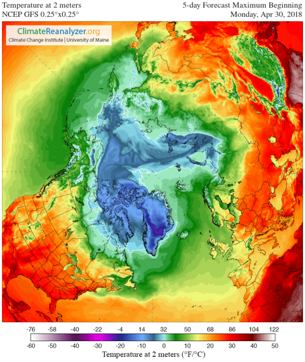
(5-Day
forecast maximum temperatures show considerable warm air invasions
proceeding throughout the Arctic. In many cases, temperatures near
the North Pole will be warmer than regions far to the south. An
impact of the warming world ocean on the Arctic environment. Image
source: Climate
Reanalyzer.)
But
the main warming event for the Arctic this week will occur in the
region of the Fram Strait east of Greenland. A strong low pressure
system near Iceland is expected to drive wave after wave of much
warmer than normal air north into the Arctic. This warm air thrust
will bring with it temperatures in some places that exceed 20 C above
average. Overall, Arctic
Ocean basin temperatures are expected to average more than 2.3 C
warmer than normal for the entire first week of May. Such
high temperature departures are particularly notable for this time of
year — as Arctic thermal variance tends to moderate during spring
and summer.
The
system will push above freezing temperatures deep into the Arctic —
generating a repeat of the strange flip-flop that has become so
common recently where temperatures near the North Pole are much
warmer than readings further south. Warmer than freezing temperatures
will also over-ride coastal portions of northeastern Greenland in yet
another odd aspect of the event.
Warm
storm effects including gale force winds and waves of 8-12 feet will
provide added effect to above freezing temperatures in impacting the
sea ice throughout the Fram Strait and northeast Greenland region.
Increased insolation due to sunlight spreading over the region will
also add to the overall potential for melt.
No comments:
Post a Comment
Note: only a member of this blog may post a comment.