

Potential Historic Arctic Warming Scenario in the GFS Model Forecast for Late May
21
May, 20188
For
years, Arctic watchers have been concerned that if May and June ran
much warmer than average following an equally severe winter, we could
see substantial sea ice losses, severe Arctic fires, and related
knock-on global weather effects.
This May, temperatures over the Arctic Ocean have run much warmer than average. And in the GFS model forecast, we see a prediction for a historic Arctic temperature spike during late May
This May, temperatures over the Arctic Ocean have run much warmer than average. And in the GFS model forecast, we see a prediction for a historic Arctic temperature spike during late May
(Discussion
of a potentially historic Arctic warming event for late May of 2018.
Information for this analysis provided by Climate
Reanalyzer, Global
and Regional Climate Anomalies,
and DMI.)
According
to GFS
model analysis,
temperatures for the entire Arctic region could spike to as high as
3.5 degrees Celsius above average from Saturday, May 26 through
Tuesday, May 29th. So much warming, if it does occur, would shatter
temperature records around the Arctic and accelerate the summer melt
season by 2-4 weeks. It would also elevate Arctic fire potentials
while likely increasing upstream severe weather risks to include
higher potentials for droughts, heatwaves and severe rainfall events
(as we have seen recently across the Eastern U.S.).
The
model run indicates three ridge zones feeding much warmer than normal
air into the Arctic. The zones hover over Eastern Siberia, Western
North America, and Central Europe through the North Atlantic and
Barents Sea — pushing wave after wave of warmth into the Arctic
Ocean region.
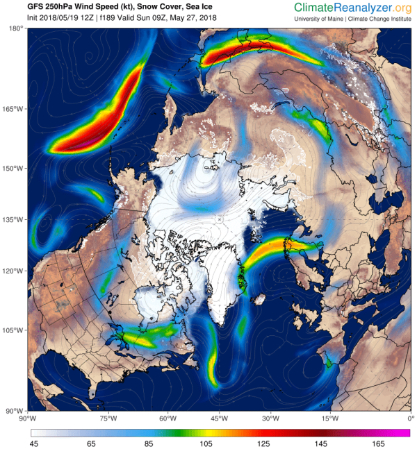
(Three
ridges transferring heat into the Arctic are feeding the potential
for a major polar temperature spike over the next ten days. Image
source: Climate
Reanalyzer.)
Over
the coming days, this
three-pronged flood of warm air could push temperatures over the
Arctic Ocean to 2-10 C above average temperatures while Western North
America, Eastern Siberia, and the Scandinavian countries could see
the mercury climb to 5 to 20 degrees Celsius above average.
This translates to 70 to 80 degree (Fahrenheit) temperatures for
Eastern Siberia above the Arctic Circle, mid 70s to mid 80s for near
Arctic Circle Alaska, and temperatures in the 70s to 80s for
Scandinavia. For the Arctic Ocean, it means above freezing
temperatures for most zones. Zones that are likely to see more rapid
sea ice melt as a result.
Upstream
effects include the
potential continuation and emergence of fixed severe weather
patterns.
Extreme heat will tend to intensify for Western North America, while
a pattern that favors severe rainfall is likely to remain in place
for the Eastern U.S. Meanwhile, South-Central Asia through the Middle
East are likely to see very extreme daytime high temperatures. Fire
risks will tend to rise from Alberta to the Northwest Territory into
Alaska and on through Central and Western Siberia as much warmer than
normal temperatures take hold and Arctic lightning storms
proliferate.
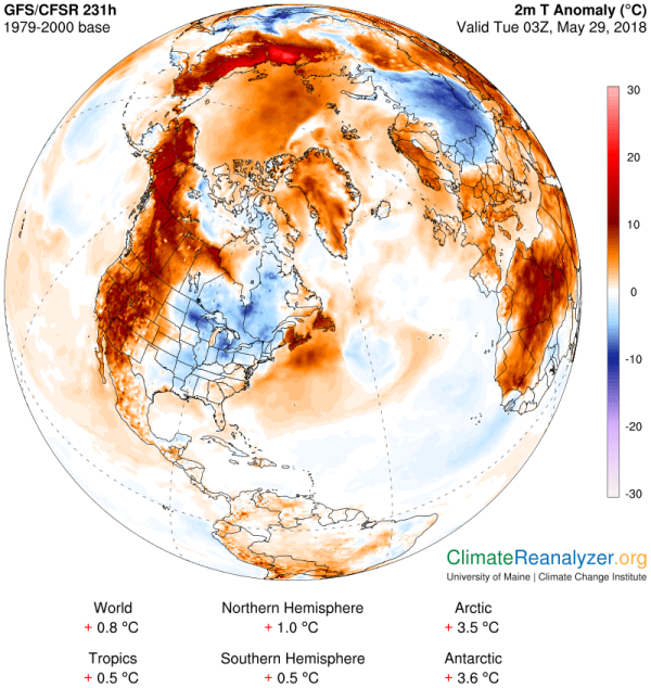
(Forecast
Northern Hemisphere temperature anomaly patterns hint at a hot or
unstable late spring pattern for many regions as the pole inters
record warm territory. Image source: Climate
Reanalyzer.)
It’s
worth noting that should such an event occur during late May, it
would represent yet another major and historic temperature departure
for an Arctic zone that has thus far seen severe winter warming and
related loss of sea ice. The concern is that eventually such heating
would result in ice free conditions during summer — although when
is a subject of some debate.
To
this point, it is also worth noting that we should take the present
GFS forecast with a bit of a grain of salt. Such amazingly warm
temperatures are still 6-10 days away. Forecasts beyond the 3 day are
notably fickle. And
this particular model has run a bit hot of late.
However, it is worth noting that the model has been correct in
predicting a much warmer than normal May. And that we have already
experienced one historic temperature spike during early May. So a
pattern that demonstrates the potential for such extreme warming has
clearly taken hold.
No comments:
Post a Comment
Note: only a member of this blog may post a comment.