BAGHDAD, Iraq — Iraqis swelter under a heatwave as temperatures soar to more than 49 degrees Celsius (120 degrees Fahrenheit) amid a lack of electricity.
Shoppers and passersby in one of Baghdad's shopping districts are braving the heat with makeshift sprinkler systems and fans.
Temperatures in central and southern Iraq soared to more than 49 degrees Celsius (120 degrees Fahrenheit) this week.
Iraqis say they are struggling to cope with the heat amid the lack of electricity in the country.
"I work in this market and come here to cool down using these water sprinklers. After work, I go home where water and electricity services are not available, that's how it is in Iraq," says Baghdad resident Abu Mustafa.
Power outages in Baghdad have increased amid the soaring heat and the demand for ice and power generators is on the rise.
The price of a block of ice, usually sold for around 2,000 Iraqi dinars ($2), is increasing in the capital.
Iraqis have suffered from power shortages for decades as the infrastructure suffered from neglect brought on by wars and UN trade sanctions under Saddam Hussein.
Billions of dollars have been spent trying to fix the power grid since the 2003 invasion, but many Iraqis, mainly Baghdad residents, still only receive an estimated 12 hours of power per day.
Accelerated melting of both the Arctic sea ice and Greenland Ice Sheet is near-certain the next several days as a very powerful high pressure system sets up over the Arctic Ocean. This will allow for days of clear, sunny weather over the Arctic Ocean and much of Greenland with temperatures above freezing over not only the Arctic Ocean but over the interior of the Ice Sheet. In fact, temperatures will be above freezing not only during the day, but also during the still short nights for many areas of Greenland.
High temperatures Friday (today) over Greenland and the Arctic. Also see the hot weather over Scandinavia.
Tuesday Forecast Highs over Greenland.
Tuesday Night Forecast Lows.
Wednesday Forecast Highs.
High surface temperature anomalies forecast over Greenland much of next week. Tuesday morning will see average Greenland anomalies +6.3 C above pre-industrial climatology. I adjusted the anomaly shown below (which is based on 1981-2010 climate) by +1.8 C.
Initially a small cyclone will bring rain and interior freezing precipitation to the central east coast and east-central Greenland. This, followed by anomalous warmth may focus much of the surface melt from the the eastern half of the ice sheet next week. Shown below total accumulated precipitation through 7 am CDT Monday. Most of this precipitation is expected over the weekend.
Here is the Tuesday and Wednesday forecast normalized 500 millibar height anomalies (shows how anomalous the high pressure system in the middle atmosphere). Very anomalously strong high centered over the Greenland Sea.
The very anomalously strong surface high pressure system forecast Sunday. The surface air flow will be favorable for sea ice melting and breaking up to be transported into the Barents Sea and also blow offshore from the north shore of Greenland and the Canadian Archipelago.
In a normal climate, this break from offshore winds wouldn't be an issue because of thick, multi-year ice...but such ice has become largely extinct, causing very thin ice to break up off the north shore of Greenland and the Canadian Archipelago.
Below is a polar-orbiter image of Greenland on July 24th. Note the break up of ice on the northeast coast, well as around the Canadian Archipelago closer to the Beaufort Sea farther west.
Close up of the north Greenland break up. Offshore winds the next week will make further break up from the coast more likely.
Close-up of the break up of ice along the Canadian islands in the middle and the Beaufort Sea on the left of the image. Also notice the cracks in the sea ice sheet over the open ocean above to the right of the islands. Northwest Greenland is in the bottom right corner.
Estimated sea ice thickness...most of the ice near and along the north coast of Greenland and the Canadian Archipelago is only 2-2.5 meters thick, with isolated areas up to 3 meter thick ice only right up against the shorelines. Much of the rest of the ice around the Arctic Ocean is only 0.5-1 meter thick. All of this ice appears easily prone to break up.
The current sea ice extent and concentration vs. the 1981-2010 climatological extent. Dramatic.
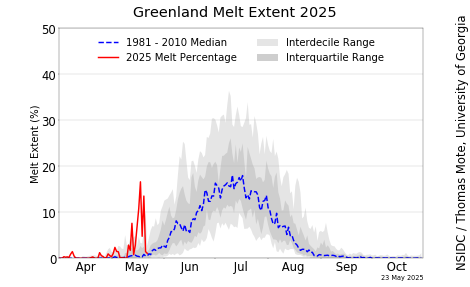
Greenland Ice Sheet Surface Melt Extent
Abrupt climate change is leading to the ongoing destruction of the sea ice and Greenland Ice sheet. The loss of sea ice is accelerating Arctic warming causing major jet stream disturbances (including intense heatwaves and wildfires in the mid-latitudes and Arctic), increased wave action and coastal erosion from cyclones, and rapidly melting permafrost which is releasing carbon dioxide, methane and nitrous oxide. The heatwaves over Greenland are and will accelerate sea level rise.
For daily updates on the state of the global cryosphere, see this Updating Page.
"The
Bunyip fire is worse than one that burned in the same spot on Black
Saturday," Country Fire Authority assistant chief officer Trevor
Owen said.
"Whilst
it damaged some property [in 2009] it was a very narrow finger
compared to what we're facing with this fire, because this fire has
been growing," Mr Owen told a community meeting in Pakenham.
Do we really have to turn to the UK's tabloid, the Daily Mail to get this reflected in the article.
'Paint
your phone number on the horse': Residents get chilling advice on
surviving Victorian bushfires - as authorities warn the inferno is
worse than the Black Saturday blazes that killed 173
Vic
Emergency said its too late to leave on Sunday as four major fire
closed in
Properties
in Victoria's east have been razed to the ground by bushfire
Lightning
first sparked the fires, which have since covered 4663 hectares
Owners
were told to mark horses so they could be found after fleeing the
fire
Firefighters
have warned that the inferno raging through east Victoria could be
worse than the Black Saturday bushfires almost a decade ago.
Lightning
sparked the fires in Bunyip State Park, about 65km east of Melbourne,
on Friday night.
Authorities
initially thought the fires could be maintained, but then four
separate blazes merged into one, burning out of control and resulting
in evacuation orders for more than 20 suburbs.
At
least five homes have been destroyed as the out-of-control blaze
continues to threaten residents.
Vic
Emergency issued a dire emergency warning at 7pm on Sunday for
suburbs located between Bunyip and Tonimbuk, from the south to the
north, and Tynong North to Labertouche, from the east to the west.
'You
are in danger and need to act immediately to survive. The safest
option is to take shelter indoors immediately,' the warning said.
'It
is too late to leave. Leaving now would be deadly.'
Earlier
on Sunday, residents in Bunyip, Budgeree, Dargo and Licola were
forced to flee their homes as the fire continued to close in.
Country
Fire Authority Assistant Chief Officer Trevor Owen said the fire is
more dangerous than 2009's Black Saturday bushfires, which killed 173
people and were also sparked by a lightning strike.
'It's
not a matter of if or may for further property damages that we might
see today, it's a matter of we will,' he said.
'Under
those very strong conditions experienced on that day (in 2009), it
travelled neatly, whilst it damaged some property it was a very
narrow finger compared to what we're facing with this fire, because
this fire has been growing,' Mr Owen told a community meeting in
Pakenham today.
The
owner of Jinks Creek Winery on Tonimbuk Road, Andrew Clarke, told
the Herald
Sun he
found out his property was lost while watching the news in a nearby
cafe.
'We've
lost our livelihood, we've lost horses, we've lost our whole
vineyard, we've lost our whole cellar door,' he said.
'Everything
we've worked for our entire life, it's all gone in a couple of hours.
'It's
surreal. I'm too scared to go back to look at it.'
Tina
Forte, from Tonimbuk, about 70 kilometres south-east of Melbourne, is
fearful her home, which has belonged to her family since the 1800s,
has burned to the ground.
'I'm
just really worried about the animals because we just had to run
yesterday,' she told reporters on Sunday.
'We
don't sleep, we don't care about our house we care about our
livestock,' she said.
A
former Country Fire Authority volunteer has posted a desperate plea
to Facebook about how to help horses amid the blaze.
If
it's too late to evacuate, the post tells residents to turn off their
electric fences and strip the horse.
'Strip
them down to nothing, no halter, no rugs, no fly mask, Nothing!' the
post shared by Animals Voice Equine and Canine Therapy said.
'We
do not want the metal to burn or anything to get attached or caught.'
'Purple
spray or horse make up or your makeup even! paint your phone number
onto the horse.'
The
advice also urges horse owners to cut the their tail so it doesn't
touch the ground.
'Open
all gates but first! Move them to a paddock with the shortest amount
of grass,' the post continues.
'Horses
are not dumb, don't keep them trapped, allow them to run from fire.'
The
advice has been shared almost 4000 times and some said they followed
similar instructions during the 2009 Black Saturday fires.
Kiery-Anne
Clissold, from Longwarry North, said it was the right decision to
leave.
'You
could see flames hundreds of feet high across the whole ridge and
it'd just woosh up and the flames were reaching for the sky,' she
said of the Bunyip blaze.
Other
residents have made the difficult decision to stay behind as the fire
closes in.
Steven
Clarke, from Garfield, about 70 kilometres south-east of
Melbourne, watched the fire from his property and has decided to stay
the night despite an increase in wind.
He
said the sun was blocked by smoke all day on Saturday.
The owner of Jinks Creek Winery on Tonimbuk Road, Andrew Clarke, said he found out his property (pictured) was lost while watching the news in a nearby cafe
Frank
Gibbons, the owner of Robin Hood Inn, in Drouin West, said he was
fully booked out as people flocked for accommodation after fleeing
fires.
'Last
night we had pretty much all the rooms booked ... I reckon they might
be sleeping on the bloody pool tables tonight,' he said on Sunday.
Mr Gibbons,
who survived the Black Saturday bushfires, said: 'I never
thought I'd have to do this again,' as he hosed down the pub.
Premier
Daniel Andrews urged residents to follow warnings from authorities at
a press conference alongside Emergency Management Commissioner
Andrew Crisp.
At least five homes have been destroyed (pictured) as a result of the fires this weekend
'Don't
put yourself in harm's way and potentially add to the already
considerable workload our firefighters have,' he said.
There
are about 19 fires still burning across the entire state of Victoria
and about 4663 hectares of bushland has been burnt.
The
hot and windy conditions are expected to linger until Wednesday.
The
Bureau of Meteorology's senior forecaster Tom Delamotte said the
conditions could get the best of those fighting the fires.
'This
means that if we have fires in the landscape, they could challenge
firefighters,' he said.
'This
is the hottest start to autumn in 30 years, following the hottest
summer on record.'
More
than 10,000 flee “catastrophic” bushfires in northern Australia
as flash floods from historic rains kill two in Sydney – “This is
unprecedented, uncharted”
SYDNEY,
Australia (The Telegraph) – Authorities ordered more than 10,000
people to flee from “catastrophic” wildfires moving across
north-east Australia, as heavy rains in the south-east caused
flooding that left at least two people dead.
In
the state of Queensland, a heatwave and strong winds fuelled a
massive fire that destroyed homes and led to the evacuation of all
8,000 residents from the town of Gracemere, the first time this has
happened in its 150-year history.
The
fire was threatening the larger town of Rockhampton, which is about
five miles away and has about 80,000 residents.
The
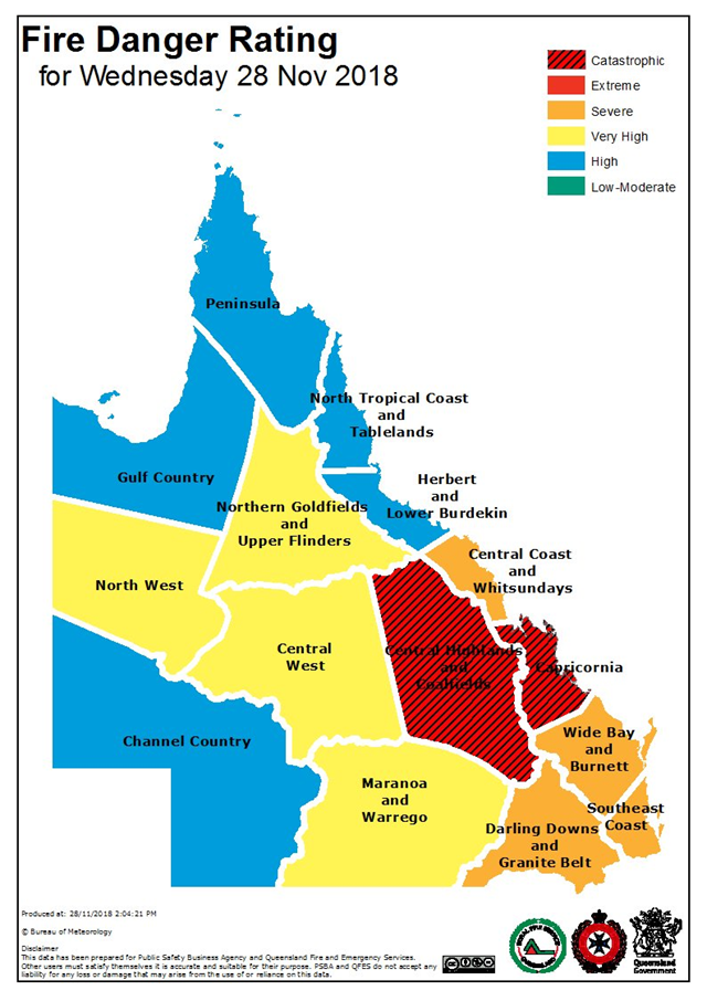
Bureau of Meteorology declared a catastrophic fire danger in the
region, the first time such a level has been applied in Queensland.
"[This
is] unprecedented, uncharted, but we have a plan,” said Annastacia
Palaszczuk, the state’s premier. […]
Queensland
Fire and Emergency Services said aerial tankers had released water on
the blaze near Gracemere and helped to “suppress” it.
"However,
that cannot operate through the night, and in some of those areas
it's actually too dangerous to have crews in those areas," said
Katarina Carroll, the head of the agency.
“We
have never, ever in this state been in this situation before.” […]
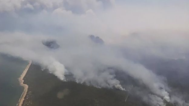
Aerial
view of bushfires in Queensland, Australia, 28 November 2018. Photo:
EPA
As
the fires continued, residents in Sydney, about 900 miles south, were
cleaning up after a violent storm that caused flash flooding and
turned roads into rivers. The city centre received a month’s worth
of rain in two hours. […]
During
the two hours of heaviest downpour, parts of the city received as
much as six inches of rain.
"For
that intensity and that duration, that’s the sort of rainfall you’d
expect to occur about once every 100 years for that particular site,"
said Ann Farrell, from the Bureau of Meteorology. [more]
(AccuWeather)
– Torrential rainfall brought a month’s worth of rainfall to
parts of Sydney in only two hours on Wednesday, resulting in
widespread flooding.
Meanwhile,
bushfires continue to ravage parts of Queensland, where months of
drought has turned the region into a tinderbox.
These
sharp contrasts in the weather are just the latest extreme weather
events to affect Australia.
Damaging
winds, a blinding dust storm and heavy mountain snow have already
been recorded earlier this month in eastern Australia.
Torrential
downpours in Sydney brought the city to a standstill on Wednesday and
resulted in at least two deaths, according to the BBC. […]
Rainfall
totaled 50-100 mm (2-4 inches) around the city, with most of the rain
falling within a two-hour period.
The
Australia Bureau of Meteorology reported that it was the wettest
November day in Sydney since 1984. […]
There
is a stark contrast in the weather farther north across Queensland.
Months of drought have left the region extremely susceptible to
wildfires.
Strong
winds associated with the storm that impacted Sydney and an ongoing
heat wave has helped to fuel more than 130 bushfires across the
state.
The
fire danger level in the state has risen to “catastrophic” for
the first time in history and prompted the evacuation of thousands of
people, the BBC reported. [more]
Sydney flooding, Queensland bushfires continue streak of extreme weatheracross Australia
Monster
dust storms; torrential rains; worst drought in living memory; deadly
wildfires; bats falling dead from trees: Summer in Aus
Spare
a thought for the Aussies just a week after a monster dust storm
measuring 500 kilometres (310 miles) blanketed Australia's southeast
after suffering one of the worst droughts in living memory, one
month's rain fell yesterday in a couple of hours that drenched
Sydney causing severe flooding but missed the drought area,
Australia's Bureau of Meteorology said it was the region's wettest
November day since 1984.
"The intensity of yesterdays
rainfall was phenomenal - 91mm fell in 90 minutes," forecaster
Rob Taggart told the Australian Broadcasting Corporation.
The
storm centred on coastal parts of New South Wales (NSW) but was
reported to have missed many inland regions affected by
drought.
Meanwhile, the Queensland Guardian claims Mandatory
evacuations of thousands of residents of Gracemere in Queensland
were underway on Thursday evening as a wildfire approached homes in
catastrophic fire conditions.
Despite the extreme danger, some
residents were refusing to leave and businesses were still trading
in the central Queensland community.
Further south, a massive
bushfire that has destroyed homes and sent 1,500 people fleeing
continued to rage in Queensland’s Deepwater region, though most
people had managed to escape.
For the third straight year,
extreme heat in Australia is causing bats to fall out of trees dead
in alarming numbers.
According to The Cairns Post, temperatures
higher than 40 deg C, 104+ deg F, have killed hundreds of flying
foxes, who just fall to the floor dead or dying from the extreme
heat.
The extreme weather has been taking a toll on the Far
North’s flying foxes, who are dropping by the dozen from trees —
and causing a potential public health risk. Wildlife carers say
they are struggling with the overwhelming numbers of bats becoming
affected by heat stress in colonies in Cairns, Edmonton, Gordonvale,
and Townsville.


 Posts
Posts