

"The situation is extremely critical," eight missing hundreds of others evacuated as Cyclone Mekunu hit Yemen's island of Socotra

24
May, 2018
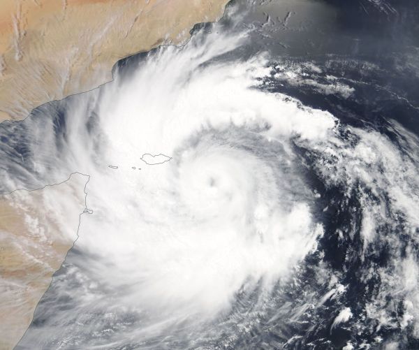
On
May 23, NASA’s Aqua satellite captured a visible light image of
Mekunu.
The
image showed the low-level centre of circulation southeast of Masirah
Island, Oman.
A
band of thunderstorms in the western quadrant stretched over the
island and skirted Oman’s mainland coast.
Eight
people were missing and hundreds of others evacuated from their homes
as Cyclone Mekunu hit Yemen's island of Socotra on Wednesday night.
Four
of the missing were crew on board a boat that sank in the Arabian Sea
and are suspected to be dead.
At
least three vessels have gone off the radar, a source told The
National.
The
cyclone has caused severe flooding and damage to houses, bringing
with it strong winds and thunderstorms.
"The
situation is extremely critical," said the former governor of
the island, Salem Abdullah Al Socotri.
"The
roads are flooded, and we cannot get out of [the northern coastal
town] of Hadibu to see what is going on in other areas of the island.
Also,
the strong winds have intercepted telecommunications, so we are
almost isolated."
Mr
Al Sacotri said the operations and control room in Hadibu received
information that a cargo ship sank about 80 kilometres off the shore
of the island.
"According
to our data, the ship was coming from Mukalla, and we still don't
know whether or not the crew survived," he told The National.
The
homes of some residents in Socotra have been completely destroyed
after the cyclone hit the island.
"Some
families who had to evacuate their homes have gone to mosques and
schools for shelter because their mud-built residences had collapsed,
the structures were not strong enough," Abdulrahman Juman, a
Yemeni activist and volunteer, said.

Odd and Dangerous Mekunu Bears Down on Oman
24
May, 2017
This
year, two tropical cyclones have sprung up in the Western Arabian
Sea. A region where, according to our understanding of
climate, “storms
do not form.” Well,
the climate has clearly changed. Because a storm is raging there now.
And for Oman today, these changes bring with them serious threats to
life and property.
(Discussion
of how climate change has altered tropical cyclone formation and
intensity dynamics in the Western Arabian Sea during 2018.)
About
five days ago, tropical storm Sagar formed east of Somalia in the
Western Arabian Sea near the Gulf of Yemen. The storm was notable due
to the fact that it was the furthest west a storm had ever formed in
this region, according
to records.
The storm then dumped copious amounts of rainfall over Somalia —
resulting in the loss of 34 lives.
Just
a few days later, a second storm, Mekunu formed in about the same
region. Tracking north, it is now threatening Oman with the potential
to hit category 2 intensity. Unlike Sagar, Mekunu poses a triple
threat due to expected very heavy rainfall, large waves, and storm
surge.
(Mekunu
rages south of Oman and Yemen after forming in the Western Arabian
Sea. Image source: NASA.)
The
region near Salalah Oman that the storm is barreling toward —
typically
receives just five inches of rainfall per year.
But Mekunu could deliver two to five times that amount (or more) in
just a few days. Moreover, the flat coastal plain is backed by
mountainous terrain to the north. The higher land produces lift that
will intensify expected rainfall. And current models predict that
more than two feet of water (24 inches) could fall on up-sloping
regions facing Mekunu’s advance. What’s notable is that these
totals keep rising and that peak local totals for the storm in
the NOAA
NCEP model show
some ridiculous amounts — up to 74 inches (see below).
Why
are peaks in this model so high? First, sea surface temperatures are
very extreme throughout the region. In the immediate vicinity of
Mekunu, ocean surfaces range from 30 to 32 degrees Celsius. The
waters are about 1 to 2 C above normal and are thus providing Mekunu
with a lot more moisture than is typical. However, the larger
environment that Mekunu is feeding off of also has much higher than
typical moisture loads. For one, sea surfaces east of Somalia have
spiked to as much as 5 C above average recently — pumping out great
loads of evaporation. Further, moisture levels over the Arabian
Peninsula are high due to moisture streaming in along a rather
intense subtropical Jet Stream moving over the also much warmer than
normal sea surfaces in the Med. The result is a much higher than
normal rainfall potential.
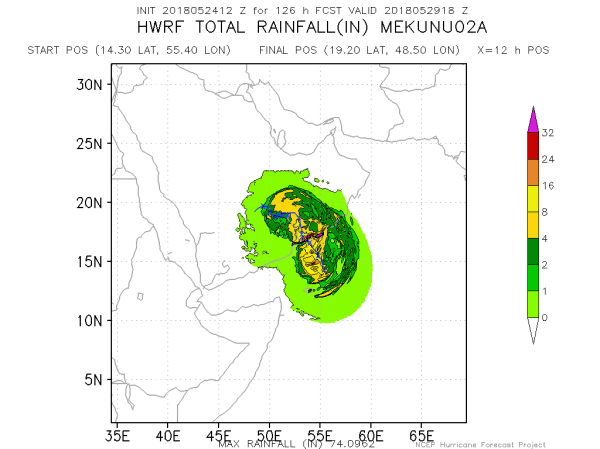
(Mekunu
presents a very severe rainfall risk for Oman in addition to a
predicted strong storm surge and very high waves. Image source: NOAA
NCEP.)
Such
heavy rains would flush floods of water into lowlands already
confronted with high waves and rising seas. According to a recent
report by
Bob Henson at Weather Underground,
wave heights could reach 24 feet along the coast. The same
report cites
storm surge expert Dr Hal Needham who
states:
The significant wave height leads me to think coastal flood potential is a real threat. At some point the water from waves crashing onshore does not have time to drain before the next wave hits. My gut feeling is that we could see a noticeable storm surge that is quite dynamic, with a lot of wave action and rapidly moving water. Expect wave heights to be tremendous.
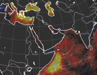
(Much
warmer than normal sea surface temperatures in the Mediterranean and
Arabian Seas are helping cyclones to form in atypical regions even as
they are lending fuel to their intensification. Image source: Earth
Nullschool.)
Mekunu’s
intensity is certainly quite high. And it is one of a recent spate of
storms to impact the region. With
research showing that the intensity of storms in the Arabian Sea has
increased during the past 20 year period.
However, the far western formation of Mekunu and Sagar add a new
twist to the story. For it appears that the zone of storm formation
is also shifting westward as sea surface temperatures rise and,
apparently, Jet Stream changes have the potential to deliver higher
levels of atmospheric moisture to the Arabian Peninsula. All of these
factors feed both storm formation and intensity potentials
No comments:
Post a Comment
Note: only a member of this blog may post a comment.