In case you didn’t get the message from my preceding posts here is Robertscribbler.
It was articles like this that got me to follow Robertscribbler.
Powerful Cyclone to Blow Hole in Thinning Arctic Sea Ice
15
August, 2016
Back
in 2012, a powerful Arctic cyclone smashed the sea ice with days of
wind and powerful waves. This year, a storm that’s nearly as
powerful threatens to make a similar mark on late-season melt. With a
very unstable Arctic weather pattern in play, there’s an outlier
possibility the dynamic is setting up for something even more
dramatic by late August.
****
Earlier
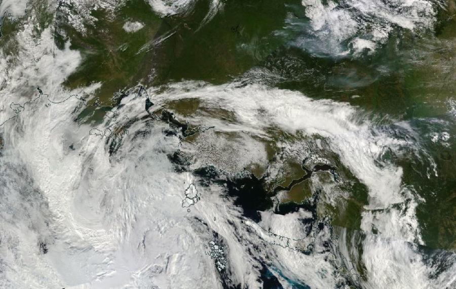
today, a
strong gale roared up out of the Laptev Sea north
of central Siberia. Feeding on the abnormally warm, moist air over
the Barents Sea and the hot air over northwestern Siberia, the storm
collided with comparatively cold air over the central Arctic.
The differences between hot/cold and damp/dry air can really
bomb out a storm system.
(Storms,
heat and moisture feed up through a high-amplitude wave in the Jet
Stream over northern Europe and Siberia and into a developing Arctic
cyclone over the Laptev Sea during the early hours of August 15,
2016. Image source: LANCE
MODIS.)
Central
pressures in the storm fell to 969
millibars and
the winds whipping out over the Laptev, East Siberian, and central
Arctic waters gusted at 45 to 55 miles per hour. Waves of 6 to 10
feet or higher roared through the newly-opened waters filled with
increasingly dispersed ice floes.
The
Great Arctic Cyclone of 2016?
This
powerful storm is pulling these strong winds over some of the weakest
and thinnest sections of Arctic sea ice. During July and August a
huge section of ice running along the 80° North Latitude line and
stretching from the Laptev, through the East Siberian Sea, and into
the Beaufort Sea grew ever more thin and eventually dispersed. Now 25
to 60 percent ice concentrations in this region abound — a tongue
of thinning which stretches nearly to the North Pole itself.
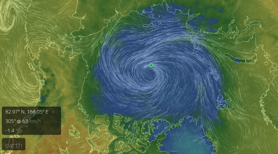
(A
powerful storm running out of the Laptev Sea and into the central
Arctic is threatening sea ice with strong winds, large waves, and the
motion of abnormally warm surface waters. Image source: Earth
Nullschool.)
The
storm is generating waves, mixing warmer-than-normal surface waters
with even higher temperature waters just below. These sea surfaces
are between 1 and 2 degrees Celsius above average over much of the
area, with pockets of 3 or even 4 C above normal surface water
temperatures interspersed. The storm’s Coriolis Effect will spin
chunks of ice out from the pack to float lonely in these
warmer-than-normal waters as they are churned by the raging swells.
Storm
Raging Over Warm Waters, Thin Ice
Currently,
the storm’s strongest winds and waves are running through a big
melt wedge that extends from the Laptev and East Siberian Seas toward
the 85th parallel. The motion and force produced by the storm’s
winds and waves will eject the ice currently located over the
northern East Siberian and Chukchi Seas even as waves eat into it.
Upwelling of warm water in the seas beneath the center of the
storm will open and disperse the ice, generating holes and polynya as
it tracks north of the 85th parallel and toward the Pole.
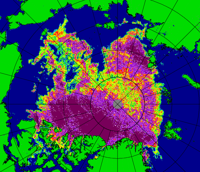
(Very
low concentrations of ice, like those seen in this Uni Bremen image,
are vulnerable to disruption and melting by storms during August and
early September. Current ice thinning and dispersal are among the
worst seen for any year. With a powerful storm now raging over the
ice, impacts to end-season totals could be significant. Image
source: Universität
Bremen.)
Compared
to the
Great Arctic Cyclone (GAC) of 2012 —
an event that helped to tip that year into the strongest late-season
melt on record — this storm is a bit weaker. The
GAC bottomed out at 963 mb and
carried on for about four days. The current storm, by comparison, is
expected to remain in place for quite some time even as it slowly
weakens over the coming days.
Arctic
sea-ice extent values are now tracking at around third lowest on
record, or just above the 2007 line. Such a strong storm certainly
has the potential to knock a big hole in the ice, possibly propelling
2016 closer to 2007 ranges or even beyond them. Surface waters
in the Laptev, East Siberian, Chukchi, and Beaufort Seas aren’t
quite as warm as they were in 2012, but there’s still a lot of
potential here for storm-associated melt. Meanwhile, the very warm
waters over the Kara and Barents Seas remain a disturbing feature.
(Above-average
sea-surface temperatures during late summer have more potential to
rapidly melt sea ice when they are churned up and put into motion by
powerful storms. Image source: NOAA
NCEP.)
Models
predict that lows will continue to feed in from the Atlantic and
northeastern Siberia along various high-amplitude waves in the Jet
Stream to combine in a triangular bite between the East Siberian Sea,
the Laptev Sea and the Pole. Such continued reinvigoration will tend
to enforce a generally stormy and unstable atmosphere. And there’s
some risk (small, but worth considering) that the current storm could
refire into something more powerful on the fuel provided by one of
these lows.
Troubling
Atmospheric Instability Loads the Dice for Future Bombification
Already,
a few of the long-range models are popping with amazing predictions
of storm-center intensity in the range of 950 to 960 mb. Both the GFS
model and CMC models separately produced these results for the nine
to 12 day timeframe. GFS had backed off its own high-intensity
forecast when this odd CMC run popped up (see below).
(CMC
10-day forecast model run showing an extremely powerful 955-mb low
just north of Svalbard on August 25th. Such a storm is
low-probability at this time, but its formation would likely result
in serious impacts to sea ice. Image source: Tropical
Tidbits.)
Though
these are long-range outliers, there is quite a lot of fuel for
strong storms in the region this year due to conditions related to
human-caused climate change. In particular, ocean surfaces in the
Barents and Kara Seas are in record-hot ranges. And the heat and
moisture coming off those waters is fuel for some serious atmospheric
instability as the Polar region attempts to cool. Any significant
cooling in the 80-90° North Latitude region would help to generate a
strong dipole between this zone and the Kara-Barents. Such a dipole
would create strong instability for storm generation.
A
low bombing out at 953 to 955 mb in ten days, as the CMC
model currently indicates,
would represent an Arctic megacyclone with serious potential to wreck
sea ice. The location predicted would generate a strong push of warm
water from the Barents and Laptev and on toward the ice-clogged polar
waters. The resulting Ekman pumping and powerful swell generation
would have the potential to generate severe ice losses in the late
August timeframe.
Probabilities
for such a storm this far out are low, but given the underlying
conditions, it’s worth putting a marker out. This is, therefore, a
situation to watch. We’ve already got one strong storm blowing away
at the ice. A one-two punch would hurt even more. In other words, the
situation in the Arctic just got really interesting. Let’s just
hope it doesn’t tilt into scary…
Links:


No comments:
Post a Comment
Note: only a member of this blog may post a comment.