From
pole to pole, twin sea ice records have scientists stunned
Chris
Mooney
6
December, 2016
We
already knew there was something pretty odd about last month,
November, in the Arctic. And in the Antarctic. At both poles, much of
the floating sea ice that usually covers the chilling ocean waters
was just … missing.
Now,
the National Snow and Ice Data Center has officially crunched the
numbers, and it is affirmed: Both the Arctic and the Antarctic were
pushing new boundaries for low sea ice. We’ll let the scientists
say it in their own words, because sometimes the calm language of
statistics and measured analysis is enough:
Average
Arctic sea ice extent for November set a record low, reflecting
unusually high air temperatures, winds from the south, and a warm
ocean. Since October, Arctic ice extent has been more than two
standard deviations lower than the long-term average. Antarctic sea
ice extent quickly declined in November, also setting a record low
for the month and tracking more than two standard deviations below
average during the entire month. For the globe as a whole, sea ice
cover was exceptionally low.
As
you can see in the figure above, Antarctic sea ice in November —
the beginning of austral summer — had actually been ticking upward
slightly in recent years. But in 2016 it just totally falls off a
cliff.
The
chart for the Arctic in November isn’t quite so dramatic, in large
part because this region is already seeing a major sea ice downtrend
tied to global warming — but it’s still pretty dramatic. Here it
is:
Moreover,
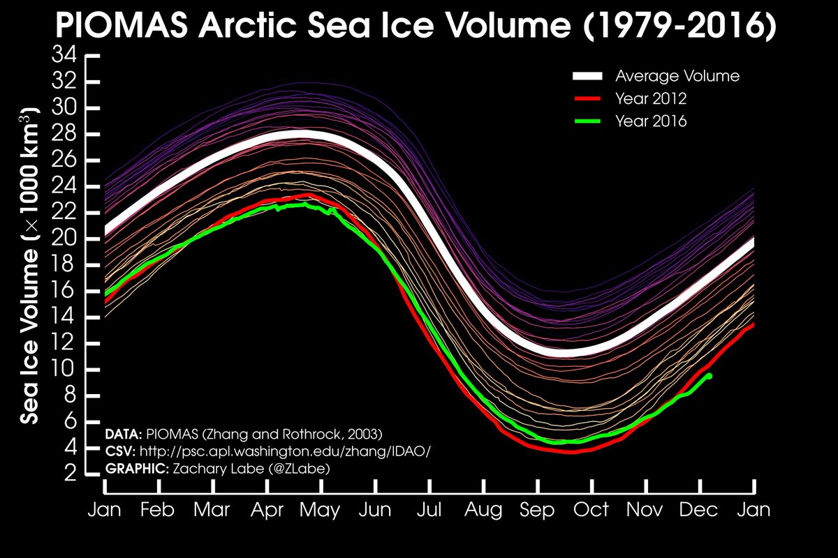
it isn’t just about the extent of sea ice — it’s the thickness
of it. Its volume. That also appears to be at an extreme low, at
least in the Arctic:
November #Arctic sea ice volume was the lowest in the satellite record (PIOMAS) for the month... ~400 km^3 less than 2012
So
what is going on here?
In
the Arctic, the explanation is simpler — temperatures have just
been extremely warm, so the ice hasn’t been able to refreeze,
heading into winter, in the way that it normally would. In fact,
there was even a super anomalous period during the month when it
actually shrank, “an almost unprecedented occurrence for November
over the period of satellite observations,” says the center.
“Air
temperatures at the 925 hPa level (about 2,500 feet above sea level)
were above the 1981 to 2010 average over the entire Arctic Ocean and,
locally up to 10 degrees Celsius (18 degrees Fahrenheit) above
average near the North Pole,” notes the group. And that’s for the
entire month of November.
In
contrast, Antarctica’s behavior is more mysterious. Warmer than
average air temperatures were again part of the story — though not
as dramatically as in the Arctic. But what seems to also have been
dramatic is shifting wind patterns around Antarctica, which created
areas with little ice.
“The
Antarctic is interesting because it had been high in recent years.
Maybe this marks a turn toward a declining trend, but it’s far too
soon to say for sure,” said Walt Meier, a sea ice expert with NASA.
This
leads to a total picture in which global sea ice — the Arctic and
Antarctic summed together — is just extremely low:
Now,
granted, some scientists do not particularly like grouping Antarctic
and Arctic sea ice together to create a figure like this one. After
all, the Arctic record came at a time when the ice was refreezing,
while the Antarctic one came at a time when it is melting — each
according to its seasonal cycle, but in opposite hemispheres.
“It
really is stunning,” said Meier of the twin low records. “But I’d
hesitate to draw any major conclusions. ‘Global’ sea ice is not
really indicative because the environments are so different. And of
course they’re in opposite seasons.”
They
are. And yet here we stand with twin records — synchronous,
bizarre, and hard not to be struck by.


 Zack Labe


No comments:
Post a Comment
Note: only a member of this blog may post a comment.