

Regions Near North Pole to Hit Above Freezing Three Days Before Christmas
19
December, 2016
In
our cultural mythology we consider the North Pole to be this
permanently frozen wonderland. And, during the 20th Century, the
depiction was mostly true. Explorers venturing into the Arctic at
that time found towering floes of ice — often measuring 15 to 20
feet high. And, up until the mid 2000s, the Arctic Ocean was
permanently frozen from Continent to Pole even during summer. So
adventurous skiers could strike out from northern Siberian, and treck
to the pole over ice in months like June and July. Now
such expeditions require the use of a kayak —
if they occur at all.

(A
warm storm over Svalbard joins with a chain of systems running from
the North Atlantic to the Pole to drive gale force winds and above
freezing temperatures into the Arctic in this December 22nd GFS model
prediction. Image source: Earth
Nullschool.)
Back
then, the polar zone in the north appeared to be mostly solid. And if
ice moved or melted — it was a slow grind or a rare event. No more.
Now, Arctic sea ice extent values have plummeted and the thinner ice
that remains is often melting, cracking, and mobile. Now,
increasingly, during late fall and early winter temperatures have
been rising to near or above freezing. Last
year a powerful storm system pulled warming air up out of the North
Atlantic — pushing temperatures over the North Pole to above
freezing on December 29th.
One month later, during late January of 2016, a
similar weather system drove temperatures at the North Pole to near
freezing.
This
year, GFS model runs again show the potential for extreme above
average temperatures in the region of the North Pole three days
before Christmas. A storm in the Greenland Sea is predicted to
strengthen to 940 mb intensity on the 20th and 21st. This system is
expected to dredge warm air from the tropical North Atlantic and then
fling it all the way to the Pole.
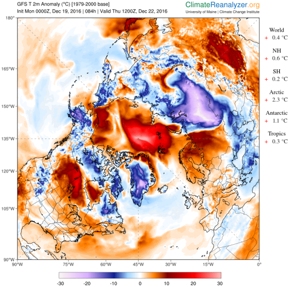
(Temperatures
may rise to as high as 55 F [31 C] above
average on
December 22nd over sections of the Arctic near the North Pole. Note
that this dynamic will tend to drive colder air out over the
Continents — especially, in this case, toward Siberia. Also note
that global temperatures remain well above average even when compared
to the warmer than normal 1979 to 2000 time-frame. Image
source: Climate
Reanalyzer.)
As
a result, temperatures in the polar region are expected to rise to
near or above freezing. According to GFS model runs, the thermometer
at 90 North is expected to hit around -0.3 C (31.5 F) at 0400 UTC on
December 22. Meanwhile temperatures on the Siberian side of the Pole
at 88 North, 109 East are predicted to hit 0.6 C or 33 F during the
same time period. By comparison, temperatures
in Southeast Texas at 27.9 N, 97.8 W — not far from from the U.S.
Gulf Coast — were about -0.3 C on Monday morning following the
passage of a cold front late Sunday.
This
level of warmth during December for the Arctic is excessive and the
expected readings are in the range of 25 to 31 degrees Celsius above
average ( 45 to 55 Fahrenheit warmer than normal). These are near
all-time record highs. But it is not just the extreme departures
predicted for Wednesday that should be cause for concern, it’s the
fact that such a high level of warmth for this region of the Arctic
is occurring with a greater and greater frequency. For human-forced
climate change — primarily driven by the burning of fossil fuels —
is now in the process of radically changing the Arctic environment.
And so much warming in the Arctic is a main driver of extreme
Northern Hemisphere weather, of glacial melt contributing to sea
level rise, and to severe loss of life among key Arctic species.
Links:
No comments:
Post a Comment
Note: only a member of this blog may post a comment.