


3 September, 2018
UPDATE
5:00 PM EDT MONDAY - HURRICANE "WARNING" NOW ISSUED, SEE
BOTTOM
Tropical
Storm Gordon just off the southwest tip of Florida is rapidly
intensifying and is now expected to become a Hurricane overnight.
Computer models show landfall between Mobile, Alabama and New
Orleans, Louisiana.
Persons
in this area should prepare NOW for severe weather. National
Hurricane Center reports, maps and models appear below . . .
Monday
Morning location off southwest Florida:
SUMMARY
OF WATCHES AND WARNINGS IN EFFECT:
A Storm
Surge Warning is in effect for...
*
Shell Beach to Mississippi-Alabama border
A Storm
Surge Watch is in effect for...
*
West of Shell Beach to the Mouth of the Mississippi River
*
East of the Mississippi-Alabama border to Navarre
A Hurricane
Watch is in effect for...
*
Mouth of the Pearl River to the Alabama-Florida Border
A Tropical
Storm Warning is in effect for...
*
Golden Beach to Bonita Beach
*
Craig Key to Ocean Reef, including Florida Bay
*
Okaloosa-Walton County Line westward to east of Morgan City,
Louisiana,
including Lake Pontchartrain and Lake Maurepas
A Storm
Surge Warning means there is a danger of
life-threatening
inundation,
from rising water moving inland from the coastline,
during
the next 36 hours in the indicated locations. For a
depiction
of areas at risk, please see the National Weather
Service
Storm Surge Watch/Warning Graphic, available at
hurricanes.gov.
This is a life-threatening situation. Persons
located
within these areas should take all necessary actions to
protect
life and property from rising water and the potential for
other
dangerous conditions. Promptly follow evacuation and other
instructions
from local officials.
A
Storm Surge Watch means there is a possibility of life-
threatening
inundation, from rising water moving inland from the
coastline,
in the indicated locations.
A
Hurricane Watch means that hurricane conditions are possible
within
the watch area. A watch is typically issued 48 hours
before
the anticipated first occurrence of tropical-storm-force
winds,
conditions that make outside preparations difficult or
dangerous.
A
Tropical Storm Warning means that tropical storm conditions are
expected
somewhere within the warning areas.
For
storm information specific to your area, including possible
inland
watches and warnings, please monitor products issued by your
local
National Weather Service forecast office.
DISCUSSION
AND OUTLOOK
----------------------
At
200 PM EDT (1800 UTC), the center of Tropical Storm Gordon was
located
near latitude 25.8 North, longitude 81.9 West. Gordon is
moving
toward the west-northwest near 16 mph (26 km/h) and a west-
northwestward
to northwestward motion is expected over the next
72
hours. On the forecast track, the center of Gordon will move
farther
away from the southwestern coast of Florida this
afternoon
and move across the eastern Gulf of Mexico tonight and
Tuesday.
The center of Gordon will approach the coast within
the
warning area along the central Gulf Coast by late Tuesday or
Tuesday
night, and move inland over the lower Mississippi Valley on
Wednesday.
Maximum
sustained winds have increased to near 50 mph (85 km/h) with
higher
gusts. Additional strengthening is forecast during the next
36
hours, and Gordon is expected to be near hurricane strength when
it
makes landfall along the central Gulf Coast.
Tropical-storm-force
winds extend outward up to 45 miles (75 km)
from
the center.
The
estimated minimum central pressure is 1007 mb (29.74 inches).
HAZARDS
AFFECTING LAND
----------------------
STORM
SURGE: The combination of a dangerous storm surge and the
tide
will cause normally dry areas near the coast to be flooded by
rising
waters moving inland from the shoreline. The water could
reach
the following heights above ground somewhere in the indicated
areas
if the peak surge occurs at the time of high tide...
Shell
Beach to the Mississippi-Alabama border...3 to 5 ft.
Navarre
Florida to the Mississippi-Alabama border...2 to 4 ft.
Shell
Beach to the Mouth of Mississippi River...2 to 4 ft.
Mouth
of the Mississippi River to the Louisiana-Texas border...1 to
2
ft.
The
deepest water will occur along the immediate coast near and to
the
east of the landfall location, where the surge will be
accompanied
by large waves. Surge-related flooding depends on the
relative
timing of the surge and the tidal cycle, and can vary
greatly
over short distances. For information specific to your area,
please
see products issued by your local National Weather Service
forecast
office.
RAINFALL:
Gordon is expected to produce total rain accumulations of
2
to 4 inches over the central and northwestern Bahamas, the Florida
Keys,
and South Florida through early Tuesday. Isolated maximum
amounts
of 8 inches are possible over the southern Florida
peninsula.
Gordon
is expected to produce total rain accumulations of 4 to 6
inches
over southern Alabama, southern Mississippi and Louisiana,
with
isolated maximum amounts of 8 inches through early Thursday.
These
rainfall amounts may cause flash flooding.
WIND:
Tropical storm conditions will continue through this
afternoon
in the warning areas across South Florida and the Florida
Keys.
Tropical storm conditions are expected within portions of the
central
Gulf Coast warning area by late Tuesday, with hurricane
conditions
possible late Tuesday or Tuesday night in the hurricane
watch
area.
TORNADOES:
A couple of tornadoes are possible through tonight
across
the southern and west-central Florida Peninsula.
NEXT
ADVISORY
-------------
Next
complete advisory at 500 PM EDT.
$$
Forecaster
Stewart


A Hurricane Watch has been issued for the #Mississippi and #Alabama coastlines, and a Storm Surge Warning has been issued for the Mississippi and portions of the Louisiana coastlines.
This means storm surge inundation of up to 5 ft above dry ground and winds >75mph are possible.
EVACUATIONS
"A
voluntary evacuation was issued in Grand Isle on Monday, Sept. 3,
2018 while that area remains in a Tropical Storm Warning from
Tropical Storm Gordon."
SATELLITE
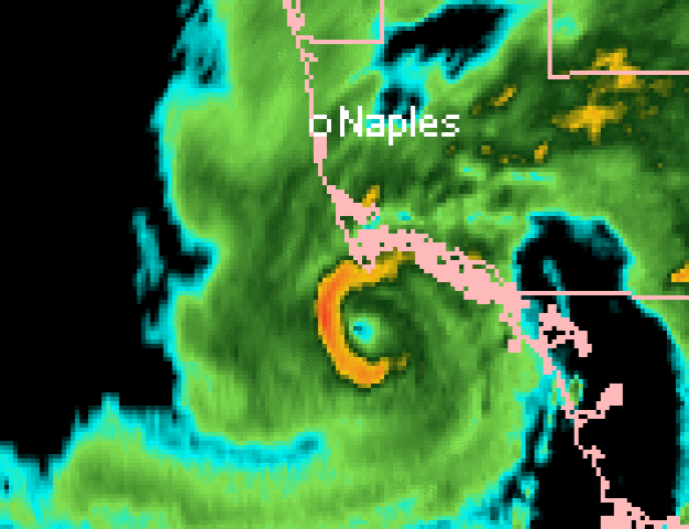
The center of Tropical Storm #Gordon will soon emerge over the Gulf of Mexico off of the Everglades.
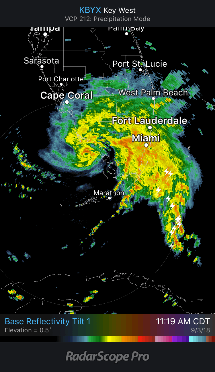
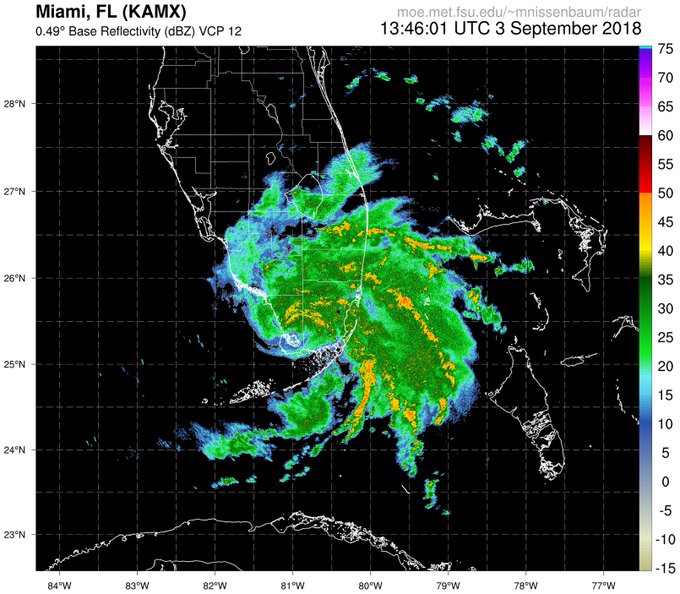
Radar loop from @nissenwx: moe.met.fsu.edu/~mnissenbaum/r…
UPDATE 5:00 PM EDT MONDAY --
*** HURRICANE WARNING ISSUED ***
442
WTNT32 KNHC 032038
TCPAT2

BULLETIN
Tropical Storm Gordon Advisory Number   6
NWS National Hurricane Center Miami FL       AL072018
500 PM EDT Mon Sep 03 2018

...HURRICANE WARNING ISSUED FOR PORTIONS OF THE CENTRAL GULF
COAST AND STORM SURGE WARNING EXTENDED EASTWARD...


SUMMARY OF 500 PM EDT...2100 UTC...INFORMATION
----------------------------------------------
LOCATION...26.2N 82.6W
ABOUT 50 MI...85 KM WSW OF FT. MYERS FLORIDA
ABOUT 445 MI...715 KM ESE OF THE MOUTH OF THE MISSISSIPPI RIVER
MAXIMUM SUSTAINED WINDS...50 MPH...85 KM/H
PRESENT MOVEMENT...WNW OR 300 DEGREES AT 17 MPH...28 KM/H
MINIMUM CENTRAL PRESSURE...1006 MB...29.71 INCHES


WATCHES AND WARNINGS
--------------------
CHANGES WITH THIS ADVISORY:

The Storm Surge Warning has been extended eastward to Dauphin
Island, Alabama.

A Hurricane Warning has been issued from the Mouth of the Pearl
River to the Alabama-Florida Border. This warning replaces the
Hurricane Watch and Tropical Storm Warning for this area.

The Tropical Storm Warning for the Upper Florida Keys and from
Golden Beach to Chokoloskee, including Florida Bay, has been
discontinued.

SUMMARY OF WATCHES AND WARNINGS IN EFFECT:

A Storm Surge Warning is in effect for...
* Shell Beach to Dauphin Island

A Storm Surge Watch is in effect for...
* West of Shell Beach to the Mouth of the Mississippi River
* East of Dauphin Island to Navarre

A Hurricane Warning is in effect for...
* Mouth of the Pearl River to the Alabama-Florida Border

A Tropical Storm Warning is in effect for...
* Chokoloskee to Bonita Beach
* West of the Mouth of the Pearl River to east of Morgan City,
Louisiana, including Lake Pontchartrain and Lake Maurepas
* Alabama-Florida Border to Okaloosa-Walton County Line

A Storm Surge Warning means there is a danger of life-threatening
inundation, from rising water moving inland from the coastline,
in the indicated locations. For a depiction of areas at risk, please
see the National Weather Service Storm Surge Watch/Warning Graphic,
available at hurricanes.gov. This is a life-threatening situation.
Persons located within these areas should take all necessary actions
to protect life and property from rising water and the potential for
other dangerous conditions. Promptly follow evacuation and other
instructions from local officials.

A Storm Surge Watch means there is a possibility of life-
threatening inundation, from rising water moving inland from the
coastline, in the indicated locations.

A Hurricane Warning means that hurricane conditions are expected
somewhere within the warning area. Preparations to protect life
and property should be rushed to completion.

A Tropical Storm Warning means that tropical storm conditions are
expected somewhere within the warning areas.

For storm information specific to your area, including possible
inland watches and warnings, please monitor products issued by your
local National Weather Service forecast office.


DISCUSSION AND OUTLOOK
----------------------
At 500 PM EDT (2100 UTC), the center of Tropical Storm Gordon was
located by NOAA Doppler weather radars near latitude 26.2 North,
longitude 82.6 West. Gordon is moving toward the west-northwest near
17 mph (28 km/h) and a west-northwestward to northwestward motion is
expected over the next 72 hours.  On the forecast track, the center
of Gordon will move farther away from the southwestern coast of
Florida early this evening, and move across the eastern Gulf of
Mexico tonight and Tuesday. The center of Gordon will approach the
central Gulf Coast within the warning area late Tuesday or Tuesday
night, and move inland over the lower Mississippi Valley on
Wednesday.

Maximum sustained winds are near 50 mph (85 km/h) with higher gusts.
Gradual strengthening is forecast during the next 36 hours, and
Gordon is expected to be a hurricane when it makes landfall along
the central Gulf Coast.

Tropical-storm-force winds extend outward up to 45 miles (75 km)
from the center.

The estimated minimum central pressure is 1006 mb (29.71 inches)
based on earlier reports from an Air Force Reserve reconnaissance
aircraft.


HAZARDS AFFECTING LAND
----------------------
STORM SURGE:  The combination of a dangerous storm surge and the
tide will cause normally dry areas near the coast to be flooded by
rising waters moving inland from the shoreline. The water could
reach the following heights above ground somewhere in the indicated
areas if the peak surge occurs at the time of high tide...

Shell Beach to Dauphin Island, Alabama...3 to 5 ft.
Navarre Florida to Dauphin Island, including Mobile Bay...2 to 4 ft.
Shell Beach to the Mouth of Mississippi River...2 to 4 ft.
Mouth of the Mississippi River to the Louisiana-Texas border...1 to
2 ft.

The deepest water will occur along the immediate coast near and to
the east of the landfall location, where the surge will be
accompanied by large waves. Surge-related flooding depends on the
relative timing of the surge and the tidal cycle, and can vary
greatly over short distances. For information specific to your area,
please see products issued by your local National Weather Service
forecast office.

RAINFALL:  Gordon is expected to produce total rain accumulations of
2 to 4 inches over the northwestern Bahamas, Florida Keys, and South
Florida through early Tuesday. Isolated maximum amounts of 8 inches
are possible over the southern Florida peninsula.

Gordon is expected to produce total rain accumulations of 4 to 6
inches over southern Alabama, southern and central Mississippi, and
southeastern and northeastern Louisiana, with isolated maximum
amounts of 8 inches through late Thursday.

These rainfall amounts may cause flash flooding.

WIND:  Tropical storm conditions will continue for the next few
hours in the warning area across southwestern Florida. Tropical
storm conditions are expected within portions of the central Gulf
Coast warning area by late Tuesday, with hurricane conditions
expected late Tuesday or Tuesday night in the hurricane warning
area.

TORNADOES:  A couple of tornadoes are possible through tonight
across the southern and west-central Florida Peninsula.


NEXT ADVISORY
-------------
Next intermediate advisory at 800 PM EDT.
Next complete advisory at 1100 PM EDT.

$$
Forecaster Stewart
No comments:
Post a Comment
Note: only a member of this blog may post a comment.