

"Hurricane Irma continues to strengthen much faster than pretty much any computer model predicted as of yesterday or even this morning"
Irma Turning Into Monster Hurricane: "Highest Windspeed Forecasts I've Ever Seen"
31
August, 2017
Hurricane
Irma continues to strengthen much faster than pretty much any
computer model predicted as of yesterday or even this morning.
Per the National
Hurricane Center's (NHC) latest
update, Irma is currently
a Cat-3 storm with
sustained winds of 115 mph but is expected
to strengthen to a devastating Cat-5 with winds that could top out at
180 mph or more.
Here is the latest from the NHC as of 5PM EST:
Irma has become an impressive hurricane with intense eyewall convection surrounding a small eye. Satellite estimates continue to rapidly rise, and the Dvorak classifications from both TAFB & SAB support an initial wind speed of 100 kt. This is a remarkable 50-kt increase from yesterday at this time.
Irma continues moving west-northwestward, now at about 10 kt.
There has been no change to the forecast philosophy, with the hurricane likely to turn westward and west-southwestward over the next few days due to a building ridge over the central Atlantic. At long range, however, model guidance is not in good agreement on the strength of the ridge, resulting in some significant north-south differences in the global models. I am inclined to stay on the southwestern side of the model guidance, given the rather consistent forecasts of the ECMWF and its ensemble. In addition, the strongest members of the recent ensembles are on the southern side on the consensus, giving some confidence in that approach.
FORECAST POSITIONS AND MAX WINDS
INIT 31/2100Z 17.3N 34.8W 100 KT 115 MPH
12H 01/0600Z 17.8N 36.2W 105 KT 120 MPH
24H 01/1800Z 18.2N 38.3W 105 KT 120 MPH
36H 02/0600Z 18.3N 40.7W 105 KT 120 MPH
48H 02/1800Z 17.9N 42.9W 105 KT 120 MPH
72H 03/1800Z 16.8N 47.5W 110 KT 125 MPH
96H 04/1800Z 16.0N 52.0W 115 KT 130 MPH
120H 05/1800Z 16.5N 56.5W 120 KT 140 MPH
As
of now, Irma remains in the far eastern Atlantic ocean and is moving
west at roughly 11.5 mph. Based on current projections, the
storm will make its first landfall in the eastern Caribbean sometime
toward the middle of next week.

Longer
term computer models still vary widely but suggest that Irma will
make landfall in the U.S. either in the Gulf of Mexico or
Florida. Meteorological
Scientist Michael Ventrice of the Weather Channel is forecasting
windspeeds of up to 180 mph,
which he described as the "highest
windspeed forecasts I've ever seen in my 10 yrs of Atlantic hurricane
forecasting."

These are the highest windspeed forecasts I've ever seen in my 10 yrs of Atlantic hurricane forecasting. #Irma is another retiree candidate.
In a separate tweet, Ventrice had the following troubling comment: "Wow, a number of ECMWF EPS members show a maximum-sustained windspeed of 180+mph for #Irma, rivaling Hurricane #Allen (1980) for record wind"
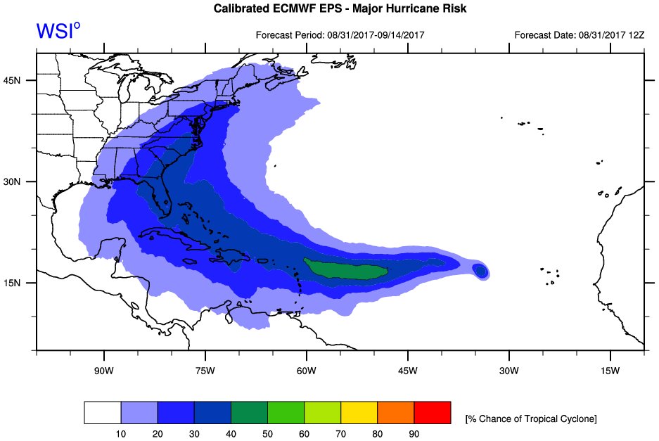
The Weather Channel meteorologist also calculated the odds for a landfall along the eastern seaboard at 30%.
Up to a 30% chance via the 12Z Calibrated ECMWF EPS for a landfalling Major Hurricane somewhere along the eastern seaboard #Irma


Meanwhile, the Weather Channel has the "most likely" path of Irma passing directly over Antigua, Puerto Rico and Domincan Republic toward the middle of next week.


No comments:
Post a Comment
Note: only a member of this blog may post a comment.