

More than Flo: The Latest on Helene, Isaac, Olivia, Paul, and Mangkhut

10
September, 2018
| Above: The Northern Hemisphere bristled with tropical cyclones on Sunday afternoon, September 9, 2018, as shown in the WU tracking map. |
Hurricane Florence will be deservedly in the spotlight this week, but there are other threats roaming the Atlantic and Pacific as the Northern Hemisphere hurricane season hits a seasonal crescendo. With rapid intensification forecast, Florence is predicted by the National Hurricane Center to reach the North Carolina coast on Thursday as one the strongest landfalls so far north in U.S. history. Massive rains could occur for days afterward. See today’s dedicated post on Florence for more details on this very serious threat to the Carolinas and mid-Atlantic.
In the meantime, there’s plenty else to track in the tropics, including a hurricane and a typhoon that will both affect U.S. territory. Here’s a rundown from west to east, which corresponds to the rough timing of potential land impacts.
 Sunday, September 9, 2018") |
| Figure 1. Enhanced infrared Himiwari-8 satellite image of Typhoon Mangkhut at 2210Z (6:10 pm EDT) Sunday, September 9, 2018. Image credit: RAMMB/CSU/CIRA. |
Mangkhut bears down on Marianas
As it churns westward and strengthens, Typhoon Mangkhut is on track to pass through the U.S. commonwealth of the Northern Mariana Islands early Monday EDT as a Category 3-strength typhoon. As of 5 pm EDT Sunday, Mangkhut was predicted by the Joint Typhoon Warning Center to pass over or very near the island of Rota around 9Z Monday (7 pm local time) with top sustained winds between 110 and 120 mph. Mangkhut will be a large typhoon by that point, with a 100-mile-wide swath of hurricane-force winds. Rota is only about 40 miles north of the center of Guam, so northernmost Guam could experience hurricane-force winds.
A rough analog for Mangkhut is Typhoon Dolphin, which passed between Guam and Rota on May 15, 2015, as an intensifying Category 2-strength storm. Close to 400 houses were damaged on Guam, where Anderson Air Force base (on the northeast side of the island) reported top sustained winds of 84 mph and a gust to 106 mph. Damage totaled around $10 million on Guam and about $2.5 million on Rota, which is much less populated than Guam.
 Sunday, September 9, 2018") |
| Figure 2. Enhanced infrared satellite image of Hurricane Olivia at 2245Z (6:45 pm EDT) Sunday, September 9, 2018, with Hawaii at far left. Image credit: RAMMB/CSU/CIRA. |
Olivia on course to visit Hawaii on Wednesday
Hurricane Olivia is holding firm at Category 1 strength as it angles west-southwest on a well-advertised track that will make it an unwelcome visitor to the Hawaiian Islands on Wednesday. At 5 pm EDT Sunday, Olivia’s top sustained winds were set by the Central Pacific Hurricane Center at 75 mph, making it a minimal hurricane. Based purely on reconnaissance data, Olivia may have weakened to tropical storm strength on Sunday, as top flight-level winds were down to 75 mph and surface winds were even lower. However, showers and thunderstorms (convection) continued to bubble around a center with an intermittent eye (see Figure 2 above).
There is strong model agreement on a building ridge of high pressure north of Olivia that will shunt it toward the Hawaiian Islands. Only two hurricanes and two tropical storms have made landfall on the islands, and none of these approached from the east-northeast, as Olivia would (see our post from last Thursday with more on Hawaiian hurricane history).
Because of the orientation of the islands relative to Olivia’s track, only a small change in direction would make a big difference as to which island(s) might see a landfall. The GFS model has consistently brought Olivia to the Big Island, whereas the most recent run (12Z Sunday) of the European model takes Olivia across Molokai and near Oahu. Overall, models have tended to cluster around a course over or near Maui, which lies at the center of of the CPHC forecast cone. Although Olivia will be passing over progressively warmer water between now and Wednesday, wind shear will also be on the increase, so it’s most likely that Olivia will continue to weaken very gradually. CPHC predicts that Olivia will be a strong tropical storm when it reaches Hawaii.
 Sunday, September 8, 2018") |
| Figure 3. Forecast for Olivia as of 5 pm EDT (11 am HST) Sunday, September 8, 2018. Image credit: NOAA/NWS/Central Pacific Hurricane Center. |
There’s no official record of any tropical storm or hurricane making landfall on any of Hawaii’s islands other than Kauai and the Big Island, much less one arriving from this unusual angle. For the island(s) closest to Olivia’s eventual path, impacts might include tropical-storm-force winds (enough to bring down trees and power lines) and localized very heavy rain, especially wherever winds are blowing upslope. Swells and waves will be building through Wednesday, and some damaging surf may occur. Olivia won’t be stalling over Hawaii, so rains on par with the 50-plus inches recorded during the close pass of Hurricane Lane are not expected.
Tropical Storm Paul: No need to worry
For once, we have a newly named system in the Northeast Pacific—Tropical Storm Paul—that’s unlikely to become a hurricane. Located about 650 miles west-southwest of Cabo San Lucas at 5 PM EDT Sunday, Paul will remain far from land this week. It’s expected to top out as a weak tropical storm before decaying later in the week.
A Western Caribbean/Gulf of Mexico disturbance to watch
An area of disturbed weather has formed in the Western Caribbean between Cuba and Honduras, due to the interaction of a tropical wave with an upper-level trough of low pressure. This system was moving west-northwest to northwest at about 5 – 10 mph, and will enter the Gulf of Mexico by Tuesday. The upper-level trough was creating high wind shear of 30 – 40 knots, preventing development. This trough is forecast to weaken and move northward over the next few days, creating a lower shear environment in the Gulf of Mexico that may allow development to occur, before the system moves inland over Texas on Thursday or Friday. The southeast half of Texas is already facing several days of heavy rain and localized flash flood threats this week, thanks to a midlatitude disturbance that will swing over the region and slow to a halt.
None of the 12Z Sunday runs of our reliable models of predicting tropical cyclone genesis forecasted that the Caribbean system would develop, but about 30% of the 50 members of the European model ensemble predicted development. In their 8 pm EDT Sunday Tropical Weather Outlook, NHC gave the system 2-day and 5-day odds of development of 0% and 30%, respectively.
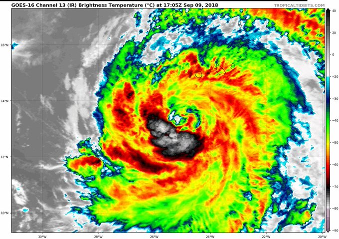
 and Hurricane Helene (right) at 2305Z (7:05 pm EDT) Sunday, September 9, 2018") |
| Figure 4. Infrared image of Tropical Storm Isaac (left) and Hurricane Helene (right) at 2305Z (7:05 pm EDT) Sunday, September 9, 2018. Image credit: tropicaltidbits.com. |
Isaac on its way to the Lesser Antilles
Compact Tropical Storm Isaac was on the verge at hurricane status at 5 pm EDT Sunday, with top sustained winds of 70 mph. Isaac was located about 1400 miles east of the Windward Islands, moving west at 12 mph. We may see some rapid ups and down in Isaac’s strength over the next several days, mainly because of its small size. Tropical-storm-force winds extended just 45 miles from Isaac’s center on Sunday night. Smaller tropical cyclones are prone to strengthening and weakening more quickly than larger systems. Any upward spike in Isaac’s strength would likely be from Sunday night to Tuesday, when Isaac will be surrounded by fairly low wind shear (5 – 10 knots) while passing over 27 – 28°C (81 – 82°F) waters. The SHIPS rapid intensification index from 18Z Sunday gives Isaac a 24% chance of building to mid-range Category 3 strength (120 mph) by late Monday.
As it continues westward toward the Lesser Antilles, Isaac will encounter increasing wind shear, especially from Wednesday onward (in part because of upper-level outflow from powerful Florence). Isaac’s compact size will make it more vulnerable than most storms to wind shear, and intensity models now agree that Isaac will likely weaken to Category 1 strength by the time it reaches the islands on Thursday. It’s too early to make a confident call on where Isaac will make landfall; at this point, the southern Leewards or northern Windwards appear most likely. NHC brings Isaac into the central Caribbean as a weakening tropical storm on Friday, though the GFS model degrades Isaac to an open wave by that point.
 |
| Figure 5. VIIRS visible image of Hurricane Helene from Sunday afternoon, September 9, 2018. At the time, Helene was passing south of the Cabo Verde Islands. Image credit: NASA. |
Helene becomes a hurricane, brushes the Cabo Verde Islands
The fourth hurricane of the 2018 Atlantic hurricane season is Helene, which intensified into a Category 1 storm with 75 mph winds at 5 pm EDT Sunday in the waters 145 miles southwest of the southernmost Cabo Verde Islands. Helene brushed the Cabo Verde Islands with heavy rain showers and strong wind gusts, but the islands missed the brunt of the storm. The Hurricane Watch and Tropical Storm Warning that were in effect for the three southernmost Cabo Verde islands, Santiago, Fogo, and Brava, has been dropped.
#Helene has been upgraded to a #hurricane - the 4th of the 2018 Atlantic hurricane season to date. On average, the Atlantic has had 2.7 hurricanes through September 9.
Helene is expected to make a gentle turn toward the west-northwest and then west over the next few days, traversing the open Eastern Atlantic. As it moves over seasonally warm water, with sea-surface temperatures (SSTs) around 27°C (81°F), Helene will be in a low-wind-shear environment (5 – 10 knots) for the next two days, so continued intensification into a Category 2 storm is likely. Only three hurricanes on record have attained Category 3 strength east of 40°W, so Helene will be in rare company if it manages to over-achieve and reach that intensity. By Wednesday, Helene will encounter high wind shear and begin to weaken, and the models agree that Helene will then be arcing northwest to north on a recurvature path through the Central Atlantic, far away from any land areas.
Dr. Jeff Masters contributed to this post.
No comments:
Post a Comment
Note: only a member of this blog may post a comment.