"Everyone
Is Panicking": Hurricane-Force Winds Slam Outer Banks As
Florence Reaches Carolina Coast
13
September, 2018
Update
II (5 pm ET): As
the hurricane force winds whip the Outer Banks, some brave (or
possibly foolhardy) residents of Wilmington, North Carolina who have
ignored the state's evacuation order shared their thoughts and fears
with CBS
Miami.
Businesses
are boarded up, and some residents were meandering around downtown as
they tried to squeeze in one last walk before the storm hit.
Claire
Holroyd laughed nervously at a reporter's question.
"The
anxiety was really heavy for the last week. I think everywhere you
go, out to the grocery stores, everyone
is panicking, you can feel it. But today I think we are all kind of
resigned to our fate in a way," said
Claire Holroyd with a nervous laugh.
Bob
Jalbert was optimistic that the dire predictions about the potential
damage from the storm could prove to be overblown - no pun intended.
"We
had a Category 2 go through here a couple years ago, Irene, and it
was manageable. And if this has dropped to two that’s good,"
said Bob Jalbert.
"Um,
but the ying to the yang, I’m concerned because although it’s
dropped to a two, it’s slowed down. I don’t know how long the
house and the trees can endure sustained winds for so long,"
said Susan Jalbert.
Winds
above 73 mph were already lashing the Outer Banks as of Thursday
afternoon. The hurricane force winds could eventually cover 15,000
square miles. Meanwhile, the flooding has already begun.
* * *
Update
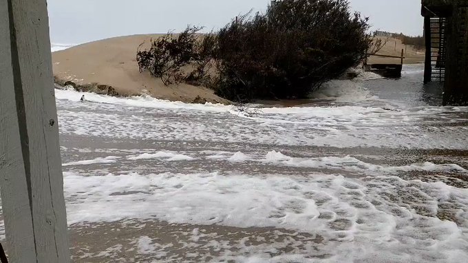
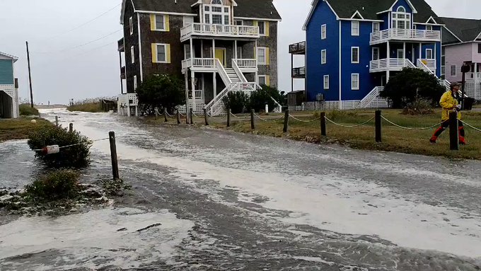
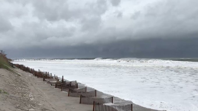
(11 am ET): As Hurricane Florence speeds toward the Carolina
coastline, the hurricane force winds and torrential rain are already
wreaking havoc in the Outer Banks, transforming downtown Cape
Hatteras into a raging river of floodwater
Despite
the NHC's decision to downgrade Florence to a Category 2 storm on
Thursday, residents should understand that these categorizations are
based solely on wind speed. The storm is still expected to dump as
much as 40 inches of rain in the affected areas, and could whip up
storm surges up to 13 feet high..
According
to the most recent measures from the NHC, Florence was still about
160 miles southeast of Wilmington, NC and is expected to make
landfall early Friday. But hurricane conditions are expected to start
hammering the coast on Thursday night.
Meanwhile,
analysts say Florence's large wind field will only add to the damages
as the storm moves inland.
"You're
going to have damaging winds for a longer period of time,"
senior hurricane specialist Stacy Stewart said in an update from the
NHC. "So
instead of maybe 120 mph winds for 30 minutes, you might end up with
90-100 mph winds for a couple of hours, or three or four hours. And
that will produce a lot of damage as well as prolong the beach
erosion."
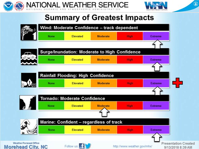
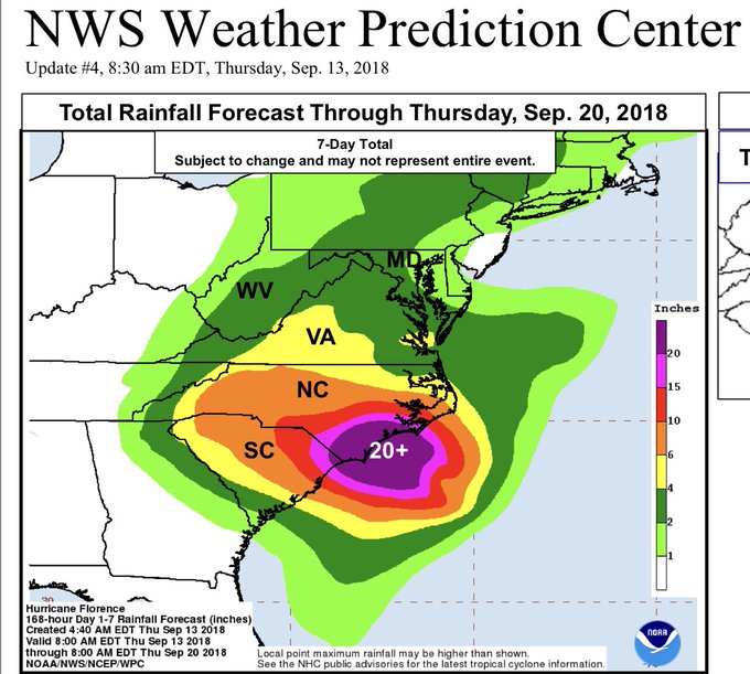
With
that in mind, here's the latest rain map from the National Weather
Service.
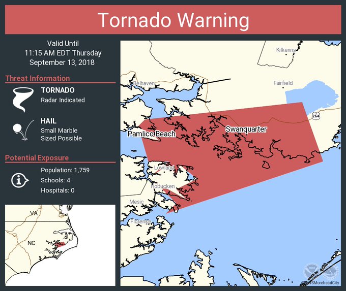
A tornado warning has been issued for some parts of coastal North Carolina.
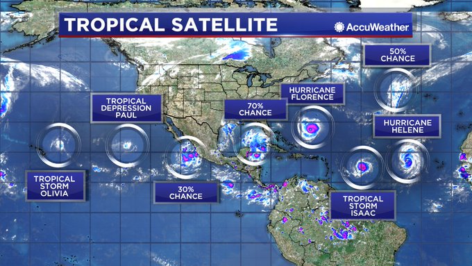
Far
from being the biggest threat facing the US coastline this hurricane
season, Florence will be followed by several other storms that
rapidly strengthening in the Atlantic. As one veteran meteorologist
remarked, "in
my 35 years forecasting the weather on TV, I have NEVER seen so much
activity in the tropics all at the same time."
View image on Twitter
Despite
repeated warnings and mandatory evacuation orders, some residents
have stubbornly decided to stick it out, stocking up on emergency
supplies that they hope will help them survive the storm. Bloomberg
reported that some gas stations in North and South Carolina have
already run out of fuel.
52%
of gas stations ran out of fuel in Wilmington, NC, 31% in
Raleigh-Durham, 25% of gas stations in Charleston, South Carolina,
12% in Charlotte.
Meanwhile,
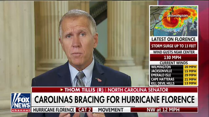
Sen. Thom Tillis appeared on Fox to remind area residents that
Hurricane Mathew was only a Category I storm when it hit North
Carolina in 2016
For
anybody looking for a real-time view, this camera situated 34 miles
off the coast of Cape Fear is showing the coming onslaught in real
time.
Here's
the tower's exact location...
*
* *
With
roughly 24 hours remaining until Hurricane Florence makes landfall in
southeastern North Carolina, the storm has reportedly weakened
to a Category 2 Hurricane. But
meteorologists warn that this isn't any reason for comfort: Because
while the storm's winds have slowed (from around 140 mph to a maximum
of 125 mph), the
potential for devastation from what's expected to be one of the most
extreme storms in American history remains acute.
And
while the storm is no longer considered a "major"
hurricane, CNN reports
that its reach has expanded. And with the first wind bands set to
batter the state beginning later Thursday, the Associated Press
warned.
Despite
the downgrade, officials warned that the storm will still have a
devastating impact.
"Do
you want to get hit with a train or do you want to get hit with a
cement truck?" said
Jeff Byard, an administrator with the Federal Emergency Management
Agency.
Analysts
are projecting as much as $30 billion in losses due to the storm. In
what looks like a best case scenario, Florence eventually could
strike as merely a Category 1 hurricane with winds less than 100 mph,
but that’s still enough to cause at least $1 billion in damage,
Weather Underground meteorology director Jeff Masters said.
According
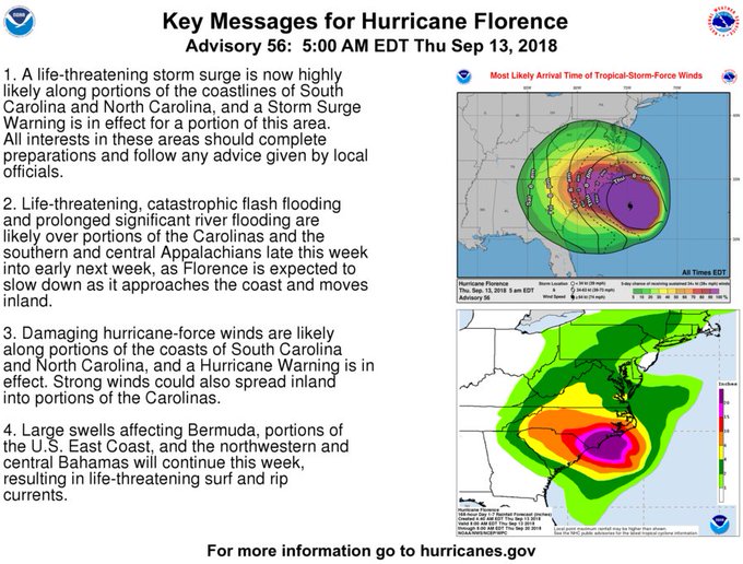
to the NHC, The
storm is expected to unleash extreme storm surges, historic flooding,
and damaging winds beginning later Thursday, with the southeastern
portion of North Carolina set to bear the brunt of Florence's wrath.
Rainfall could range between 20 inches to a staggering 40 inches.
Between the rains and the storm surge, the flooding could be
"catastrophic," the
Washington Post warned.
As the storm moves inland on Friday, a
pocket of tropical-storm-force winds nearly 400 miles wide will
engulfing much of southern North Carolina and nearly all of South
Carolina.
As
of 5 am on Thursday, the storm's winds were topping out at around 110
mph as it barreled northwest at 17 mph. Per the NHC, the storm is
about 205 miles east-southeast of Wilmington, NC. The storm's winds
extend 80 miles from its center, while tropical-storm-force winds
extend 195 miles outward.
Some
of the heavy rains associated with the storm could creep into
neighboring Georgia, which could see rains between 6 inches and 12
inches. In the Carolinas, the rain could break North Carolina's
record for a tropical storm, 24 inches, which was set in 1999 near
Wilmington. As the storm moves inland, Virginia, West Virginia ,
Maryland, Washington and Pennsylvania could also experience heavy
rains of up to 8 inches, with downed trees and flooding also a
possibility.
Here's
a breakdown on how large the storm surge could be in certain areas
(courtesy of the
Washington Post) at
its highest, the surges could reach up to 13 feet:
Cape
Fear to Cape Lookout, including the Neuse, Pamlico, Pungo and Bay
Rivers: 9
to 13 feet
North
Myrtle Beach to Cape Fear: 6 to 9 feet
Cape
Lookout to Ocracoke Inlet: 6 to 9 feet
South
Santee River to North Myrtle Beach: 4 to 6 feet
Ocracoke
Inlet to Salvo, N.C.: 4 to 6 feet
Salvo
to North Carolina/Virginia Border: 2 to 4 feet
Edisto
Beach to South Santee River: 2 to 4 feet
State
officials continued their warnings after issuing evacuation orders
affecting some 3 million people in the Carolinas. The storm's lurch
south led Georgia’s governor to declare a state of emergency
Wednesday afternoon for all 159 counties, with a population of 10.5
million people. In
the Carolinas and Virginia, more than 10 million people are under a
storm watch. Hundreds
of schools have closed, and federal officials have warned that the
millions of people in the storm's path could be without electricity
for weeks if high winds down power lines and massive rainfall floods
equipment. There are 16 nuclear reactors in the region, and crews at
the one closest to where landfall is forecast readied the station, at
Brunswick, for a shutdown.
"North
Carolina, my message is clear," a grim Gov. Roy Cooper said at a
briefing Wednesday. "Disaster
is at the doorstep and it's coming in."
"You
put your life at risk by staying," North Carolina Gov. Roy
Cooper said. "Don't plan to leave once the winds and rains
start."
Both
Cooper and South Carolina Gov. Henry McMaster told the more than 1
million people who have been directed to leave that if they don't do
so, they will be on their own.
Even
some hardened locals who have weathered previous storms are deciding
to leave, according to CNN.
"Even
the rescuers cannot stay there," he said.
Already,
more than 300,000 people have left South Carolina. In
Carolina Beach, authorities have instituted a 24-hour curfew and
ceased allowing traffic to the island via the only bridge between the
island and the mainland. The town is less than 5 feet above sea level
and officials worry that as many as 1,000 of the town's 6,300
residents plan to stick it out.
Susan
Faulkenberry Panousis has stayed in her Bald Head Island, North
Carolina home during prior hurricanes, but not this time. She packed
up what she could and took a ferry. "When that last ferry pulls
out...it's unnerving to see it pull away and know, 'That's the last
chance I have of getting off this island,'" she said Wednesday.
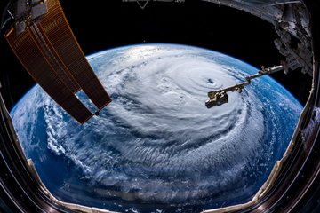
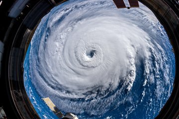
The
storm has captivated astronauts aboard the International Space
Station. Some of them have taken to tweeting pictures of the storm.
But
even after Florence passes, several other storms are brewing in the
Atlantic that could soon threaten areas along the eastern seaboard
and the Gulf Coast.
Satellite
imagery shared with the Associated Press shows the sheer size of the
storm:
Homes
Being SMASHED By 20' Waves; Collapsing - Streets Inundated with water
& Sand; Electric OUTAGES Spreading
26
November, 2014
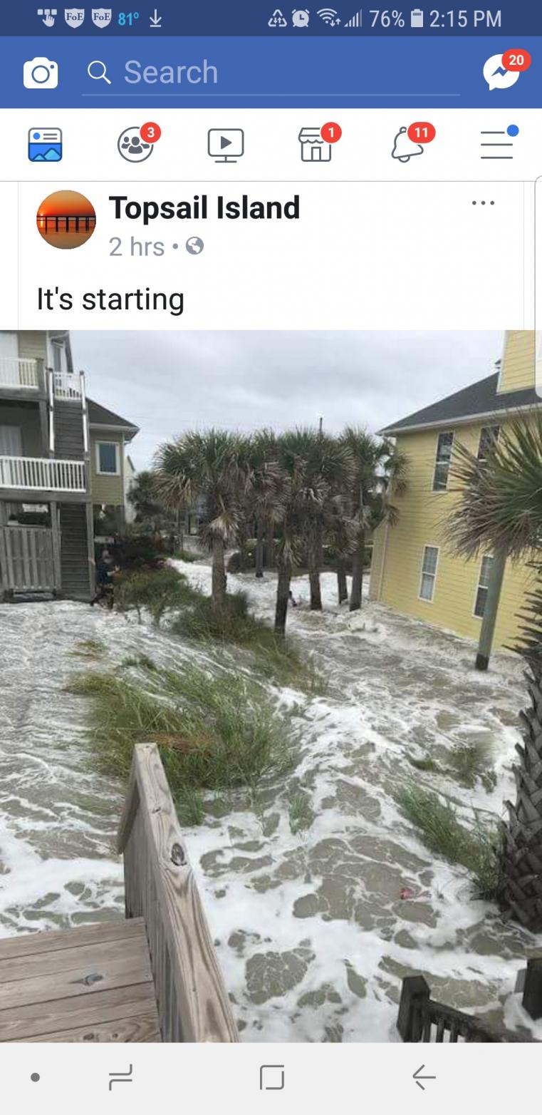
The
initial outer bands of Hurricane Florence have arrived at the
eastern-most barrier islands of North Carolina. The winds are driving
water from the Atlantic Ocean in 20
foot tall waves smashing into homes which are collapsing almost
immediately when hit.
Water
is carrying tons of sand into surrounding streets, which clogs
sewers causing almost immediate flooding.
.
. . and these are just the outer bands of the hurricane. It
will get worse from here on out. Much
worse.
Local
Sheriffs have begun asking people who CHOSE to remain, for
the names of their next-of-kin.
Such people are being personally told NO EMERGENCY RESPONDERS will
answer their calls for help until the storm is over because they were
repeatedly told to evacuate!
The
4 Minute video below begins to tell the story, and
does so far better than I can:
As
of 2:00 PM EDT, the Hurricane "eye" is still 110 miles
southeast of landfall. It is moving northwest around 10 MPH, so
it will be another ELEVEN HOURS until the eye even makes landfall.
As it gets closer, ALL the storm conditions will grow far worse.
That
means everything you see in the video above, will get so much worse,
it defies description.
For
DAYS, I have been telling people to evacuate. Some stayed.
It is very likely many of them are going to die within the next 24
hours. They were not "brave" they were stupid.
TOO
LATE!
It's
too late for these folks, These houses will be knocked off their
foundations within minutes:
And these homes are gonners in a little while as well . . .
Latest Forecast: 44" Rain!
Power
outages already are creeping up along the North Carolina coast as
tropical storm-force winds started sweeping over land.
Electric
utilities and cooperatives reported about 12,000
outages statewide as of early Thursday afternoon, with nearly
all of them at the coast. Most of the homes and businesses without
electricity are in Carteret and Craven counties. Both are north of
the eye's projected path and expected to get massive amounts of rain-
potentially 20 inches (50 centimeters) or more.
Duke Energy is
the largest of the utilities in the Carolinas. The
company predicts Carolinas power outages caused by Florence will
range from 1 million to 3 million customers. It's
got more than 20,000 workers from the Carolinas and other states in
place to restore power.
Here's the latest Update from the National Hurricane Center.
293
WTNT31 KNHC 131753 CCA
TCPAT1

BULLETIN
Hurricane Florence Intermediate Advisory Number 57A...Corrected
NWS National Hurricane Center Miami FL       AL062018
200 PM EDT Thu Sep 13 2018

Corrected distances in summary block.

...HEAVY RAINBANDS WITH TROPICAL-STORM-FORCE WINDS SPREADING ACROSS
THE OUTER BANKS AND COASTAL SOUTHEASTERN NORTH CAROLINA...
...LIFE-THREATENING STORM SURGE AND RAINFALL EXPECTED...


SUMMARY OF 200 PM EDT...1800 UTC...INFORMATION
----------------------------------------------
LOCATION...33.6N 76.0W
ABOUT 110 MI...180 KM ESE OF WILMINGTON NORTH CAROLINA
ABOUT 165 MI...270 KM E OF MYRTLE BEACH SOUTH CAROLINA
MAXIMUM SUSTAINED WINDS...105 MPH...165 KM/H
PRESENT MOVEMENT...NW OR 315 DEGREES AT 10 MPH...17 KM/H
MINIMUM CENTRAL PRESSURE...955 MB...28.20 INCHES


WATCHES AND WARNINGS
--------------------
CHANGES WITH THIS ADVISORY:

None.

SUMMARY OF WATCHES AND WARNINGS IN EFFECT:

A Storm Surge Warning is in effect for...
* South Santee River South Carolina to Duck North Carolina
* Albemarle and Pamlico Sounds, including the Neuse and Pamlico
Rivers

A Storm Surge Watch is in effect for...
* Edisto Beach South Carolina to South Santee River South Carolina
* North of Duck North Carolina to the North Carolina/Virginia border

A Hurricane Warning is in effect for...
* South Santee River South Carolina to Duck North Carolina
* Albemarle and Pamlico Sounds

A Hurricane Watch is in effect for...
* Edisto Beach South Carolina to South Santee River South Carolina

A Tropical Storm Warning is in effect for...
* North of Duck North Carolina to Cape Charles Light Virginia
* Chesapeake Bay south of New Point Comfort

Interests elsewhere in the southeastern and mid-Atlantic states
should monitor the progress of Florence.

A Storm Surge Warning means there is a danger of life-threatening
inundation, from rising water moving inland from the coastline. For
a depiction of areas at risk, please see the National Weather
Service Storm Surge Watch/Warning Graphic, available at
hurricanes.gov.  This is a life-threatening situation.  Persons
located within these areas should take all necessary actions to
protect life and property from rising water and the potential for
other dangerous conditions.  Promptly follow evacuation and other
instructions from local officials.

A Storm Surge Watch means there is a possibility of life-
threatening inundation, from rising water moving inland from the
coastline.

A Hurricane Warning means that hurricane conditions are expected
somewhere within the warning area, in this case within the next 12
to 24 hours.  Preparations to protect life and property should be
nearing completion.

A Hurricane Watch means that hurricane conditions are possible
within the watch area.  A watch is typically issued 48 hours
before the anticipated first occurrence of tropical-storm-force
winds, conditions that make outside preparations difficult or
dangerous.

A Tropical Storm Warning means that tropical storm conditions are
expected somewhere within the warning area.

For storm information specific to your area, including possible
inland watches and warnings, please monitor products issued by your
local National Weather Service forecast office.


DISCUSSION AND OUTLOOK
----------------------
At 200 PM EDT (1800 UTC), data from an Air Force Reserve Unit
Hurricane Hunter aircraft and NOAA Doppler weather radars indicate
that Florence was located near latitude 33.6 North, longitude 76.0
West.  Florence is moving toward the northwest near 10 mph (17
km/h).  This general motion, accompanied by a gradual decrease in
forward speed, is expected through today. A turn toward the west-
northwest and west at an even slower forward speed is expected by
tonight and continuing into Friday, and a slow west-southwestward
motion is forecast Friday night and Saturday.  On the forecast
track, the center of Florence will approach the coasts of North and
South Carolina later today, then move near or over the coast of
southern North Carolina and northeastern South Carolina in the
hurricane warning area tonight and Friday. A slow motion across
portions of eastern South Carolina is forecast Friday night through
Saturday night.

Data from the aircraft and Doppler weather radars indicate that
maximum sustained winds remain near 105 mph (165 km/h) with higher
gusts.  Little change in strength is expected before the eye of
Florence reaches the coast, with weakening expected after the center
moves inland.

Florence is a large hurricane. Hurricane-force winds extend outward
up to 80 miles (130 km) from the center and tropical-storm-force
winds extend outward up to 195 miles (315 km).  A NOAA reporting
station at Cape Lookout, North Carolina, recently reported a
sustained wind of 53 mph (85 km/h) and a gust to 63 mph (101 km/h).
Weatherflow private observing stations in North Carolina recently
reported a sustained wind of 53 mph (85 km/h) and a gust to 70 mph
(113 km/h) at Fort Macon, a sustained wind of 47 mph (72 km/h) and a
gust to 60 mph (97 km/h) in Ocracoke, and a sustained wind of 45 mph
(72 km/h) and a gust to 56 mph (90 km/h) in Pamlico Sound.

The estimated minimum central pressure based on recent data from
the aircraft remains at 955 mb (28.20 inches).


HAZARDS AFFECTING LAND
----------------------
STORM SURGE:  The combination of a dangerous storm surge and the
tide will cause normally dry areas near the coast to be flooded by
rising waters moving inland from the shoreline.  The water has the
potential to reach the following heights above ground if peak surge
occurs at the time of high tide...

Cape Fear NC to Cape Lookout NC, including the Neuse, Pamlico,
Pungo, and Bay Rivers...9-13 ft
North Myrtle Beach SC to Cape Fear NC...6-9 ft
Cape Lookout NC to Ocracoke Inlet NC...6-9 ft
South Santee River SC to North Myrtle Beach SC...4-6 ft
Ocracoke Inlet NC to Salvo NC...4-6 ft
Salvo NC to North Carolina/Virginia Border...2-4 ft
Edisto Beach SC to South Santee River SC...2-4 ft

The deepest water will occur along the immediate coast in areas of
onshore winds, where the surge will be accompanied by large and
destructive waves.  Surge-related flooding depends on the relative
timing of the surge and the tidal cycle, and can vary greatly over
short distances.  For information specific to your area, please see
products issued by your local National Weather Service forecast
office.

RAINFALL: Florence is expected to produce heavy and excessive
rainfall in the following areas...

Coastal North Carolina into far northeastern South Carolina...20 to
30 inches, isolated 40 inches. This rainfall will produce
catastrophic flash flooding and prolonged significant river
flooding.

Remainder of South Carolina and North Carolina into southwest
Virginia...6 to 12 inches, isolated 15 inches.

WIND:  Hurricane conditions are expected to reach the coast within
the hurricane warning area this evening or early Friday.  Tropical
storm conditions are already moving onshore within the warning
area.

TORNADOES:  A few tornadoes are possible in eastern North Carolina
through Friday.

SURF:  Swells generated by Florence are affecting Bermuda, portions
of the U.S. East Coast, and the northwestern and central Bahamas.
These swells are likely to cause life-threatening surf and rip
current conditions. Please consult products from your local weather
office.


NEXT ADVISORY
-------------
Next complete advisory at 500 PM EDT.

$$
Forecaster Stewart
The
police chief of a barrier island in Florence's bulls'-eye said he was
asking for next-of-kin contact information from the few residents who
refused to leave.
"I'm not going to put our personnel in
harm's way, especially for people that we've already told to
evacuate," Wrightsville Beach Police Chief Dan House
said.
North Carolina Gov. Roy Cooper urged residents to remain
alert despite changing forecasts.
"Don't relax, don't get
complacent. Stay on guard. This is a powerful storm that can kill.
Today the threat becomes a reality," he said.
About 5.25
million people live in areas under hurricane warnings or watches, and
4.9 million in places covered by tropical storm warnings or watches,
the National Weather Service said.
.
. . And if all that wasn't bad enough . . . .
A
Small Magnitude 2.6 EARTHQUAKE struck South Caroline near the Georgia
border at 2:27 AM EDT this morning:
UPDATE
6:59 PM EDT --
Forward
motion of the storm has virtually STALLED directly over the warm Gulf
Stream waters in the Atlantic Ocean. NHC has just INCREASED
sustained wind measurement; storm seems to be STRENGTHENING.
Nearly
70,000 are without power in North Carolina
There are 68,892
customers are currently without power statewide according to North
Carolina Emergency Management.
The top counties affected are
Carteret, Craven, New Hanover, Onslow and Pamlico, the agency
reported.
Ocean
waves are hitting the shore SO HARD they are being picked up by
earthquake seismographs!
Power Outages growing:
night.
Call it a good description of a natural disaster or "panic-mongering". Your choice.

 Posts
Posts