

An examination of sea thickness data
Seemorerocks

I
don't mind admitting that I am a little obsessed with Arctic ice
right now.
After all we are dealing with no less than the future of Creation.
As you will be aware I have been watching the changes, almost on a daily basis, along with Margo.
Neither of us has any scientific training but we do report back on what we can see with our own eyes.
I must say I have had some difficulty with some of the data, which seems to be coming up with contradictory results.
A case in point would be the following data set which comes from an EU source.

I came across the following comment on Facebook:
“You
can click the link and play with the data. No fake news here. We
have more ice now than 2015-17 in terms of volume, and
lots more than 2008 apparently. Extent might be different. I tried
going back to 1998 for a 20 year baseline, but it starts in 2004.
Lots of ice in 2004!”
The
above seems to indicate that sea ice thickness is mostly 2.0-2.5
metres thick and no less than 0.5 - 1 metre thick.
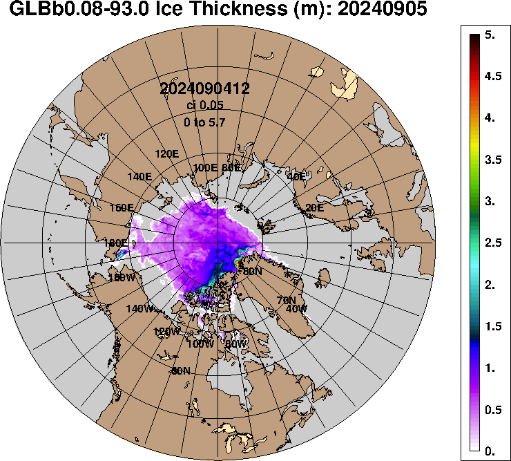
This
is in direct contradiction with data from the US Navy which indicates
that, apart from a thin area of older ice nowhere is there any ice
that is thicker than 1.0 -1.5 metres.
First,
compare the above data with the satellite picture ( I have rotated
the image for easier comparison)

Here is the latest data from the US Navy.

You will notice that all the ice on the Siberian side is almost gone. Other changes cannot be seem without zooming in - such as disappearing old ice from north of Greenland as well as Canada now. There has been considerable melting in the Beaufort sea and a lot of breakup of ice within the central plateau.
This raises the question of how you can measure the thickness of ice that has broken up to the extent it is perfectly navigable without an ice breaker?
So you can compare the above data I have rotated the image.

I have no idea of where the coming weeks are going to take us.
It all seems to come down to the central plateau and how much ice there is to melt. It may mean that there is simply too much ice to melt in the time left before the end of the melt season.
However, if I was to hazard a guess from what I am saying I would say that what I am seeing with my own eyes indicates that the ice is a lot thinner and in worse shape than the EU data would indicate.
Does this mean that we are likely to see a blue sea event next month?
I have no idea.
Perhaps, in part it comes down to how you define it.
Anything with an ice volume of 15% or less could probably be defined as a blue sea event and certainly if it is navigable without an ice breaker.I am sure that the satellite pictures will look something like what we are currently seeing on the periphery.
With the much warmer ocean melting the ice from below we may see sufficient melt.
A cyclone in the middle of this would certainly act as the coup de grace.
The world will certainly have changed forever and I suspect Guy McPherson's scenario would come into play.
In the meantime it is just a question of waiting and monitoring on a regular basis.
Thank you for the great job and thank you for what you and Margo do !! Sending LOVE your way !
ReplyDelete