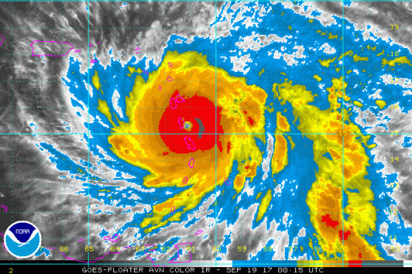
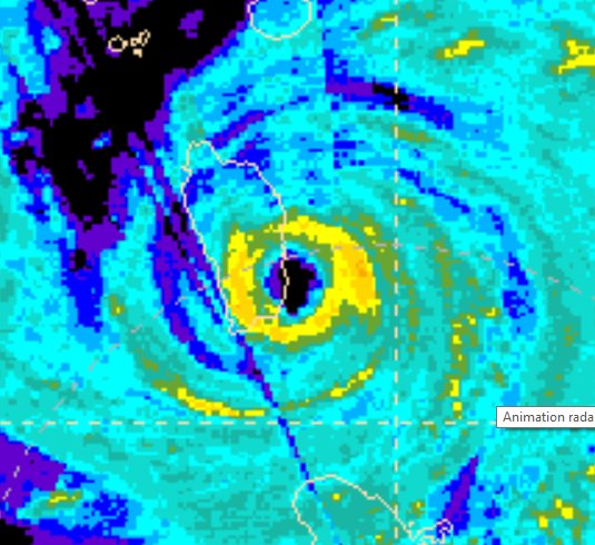
Hellish Intensification — Maria’s Winds Jump 50 mph to CAT 5 Strength in Just 12 Hours
18
September, 2017
A
special statement from the National Hurricane Center reports that
Maria has reached Category 5 intensity —
with maximum sustained winds of 160 mph and a minimum central
pressure of 924 mb. This is, perhaps, one of the most rapid
intensifications the Atlantic basin has ever seen — with the storm
seeing a 40 mb drop in pressure in approximately 6 hours and crossing
the Category 4 threshold to Cat 5 intensity in even less time.
Maria
is now a very dangerous hurricane — barreling into Dominica and the
Leeward Islands before turning toward both the U.S. Virgin Islands
and Puerto Rico over the next 36 hours. It is also the second
Category 5 storm to threaten the region in just two weeks time.
As
of this morning, Maria was a strong Category 2 Hurricane featuring
110 mph maximum sustained winds. Forecasters
noted a potential for rapid intensification as the storm began to
move over warmer than normal surface waters in
the range of 29 degrees Celsius (84 to 85 degrees F) and as the
atmospheric conditions became more favorable for storm development.
By
late morning, the storm had strengthened into a major hurricane with
120 mph maximum sustained winds. But Maria still had a few surprises
in store. The storm swiftly developed a small, pinhole, eye. Such
small eye structures enable storms to more rapidly wrap winds around
a compact center. It’s the kind of structure that can result in
very fast intensification.
After
the pinhole eye structure formed, Maria jumped to category 4 strength
with 130 mph winds by late afternoon. Then, by the 9 PM advisory from
the National Hurricane Center, the storm made the considerable leap
to Category 5 status with 160 mph maximum sustained winds.
The
storm, at this time is now zeroing in on Dominica — which is
presently seeing very rapidly deteriorating conditions.
#Maria is about to make landfall in Dominica as Cat. 5 - first Cat. 5 to make landfall (or track within ~100 miles) of Dominica on record.
Maria
presently has a smaller hurricane force wind field than Irma — with
hurricane strength winds only stretching about 15-20 miles from the
storm’s center. Those winds, however, are very intense and capable
of inflicting catastrophic damage. All within the path of this
terrible storm should seek shelter in the strongest structures
possible immediately and heed any warnings or advice from local
disaster authorities.
Conditions
in Context
Like
Irma and Harvey, Maria is tapping warmer than normal sea surface
temperatures which is helping it to reach a higher peak intensity.
This year, thunderstorms in the Inter-Tropical-Convergence-Zone
(ITCZ) have been unusually intense. Strong thunderstorms in this
region are basically the seeds that can grow into powerful tropical
cyclones. So the larger, more energetic, more moisture-rich, and more
numerous these storms, the higher potential that a strong hurricane
will ultimately form once such systems enter the Tropical Atlantic.
Warmer ocean surface temperatures are a direct upshot of human-caused
climate change and there is some evidence that climate change is also
increasing the intensity of the world’s most powerful thunderstorms
— particularly over the Equatorial regions.
In
addition to these climate change related factors, La Nina-like
conditions in the Equatorial Pacific are helping to reduce wind shear
over the Tropical Atlantic. Reduced shear helps to allow the larger
than normal storms emerging from Africa to tap the warmer than normal
surface waters across the Atlantic. So in total, this is a pretty
vicious combination of both natural and climate change related
factors. A set that is enabling one of the worst hurricane seasons on
record for the Atlantic.
(UPDATED:
UPDATES TO FOLLOW)
RELATED
STATEMENTS AND INFORMATION:
Dominica’s prime minister says he has been rescued after the roof of his residence was lost during Category 5 #Maria
Links:
The
National Hurricane Center
Hat
tip to Bostonblorp


No comments:
Post a Comment
Note: only a member of this blog may post a comment.