Hurricane Maria Intensifies To "Extremely Dangerous" Cat-4 Storm Ahead Of Puerto Rico
18
September, 2017
Does
this look familiar?
As
AP reports, Hurricane
Maria has intensified into a dangerous Category 4 storm as it bears
down on the Caribbean.
The
National Hurricane Center in Miami said Monday the storm is growing
in strength as it approaches land. The eye of the storm is expected
to pass near the island of Dominica on Monday evening.
The
center called the storm "extremely dangerous," with maximum
sustained winds of 130 mph (215 kph).
At
5 p.m. EDT, the storm was centered about 45 miles (70 kilometers)
east-southeast of Dominica.
A
Hurricane warning has been issued for Puerto Rico, Culebra, and
Vieques.
*
* *
As
we detaile earlier, less than two weeks after Hurricane Irma hammered
the Caribbean, leaving the tiny island of Barbuda uninhabitable and
hundreds of thousands of Puerto Ricans without power, Hurricane Maria
is expected to follow closely behind its predecessor, delivering
another destructive blow to the region before most areas affected by
Irma have had time to recover. As Hurricane Maria hastens toward the
eastern Caribbean, forecasters are warning that it could strengthen
into a major storm by the time it passes through the Leeward Islands
later Monday, according to CBS. That poses a huge problem for
residents of the Caribbean.
After
reaching category-one hurricane strength on Sunday, CBS reports
that Maria is expected to quickly become much stronger over the next
two days and follow a path that would take it near many of the
islands wrecked by Hurricane Irma and on to Puerto Rico, the
Dominican Republic and Haiti.
The National
Hurricane Center has
already issued advisories for much of the Caribbean. Here’s a
summary of the NHC’s latest update, including stats about Maria’s
location and attributes as of 5 a.m. Monday. Note that the storm has
maximum wind speeds of 90 mph….
"Significant
strengthening is forecast during the next 48 hours, and Maria is
expected to become a dangerous major hurricane before it moves
through the Leeward Islands," according to the National
Hurricane Center's latest update.
SUMMARY
OF 500 AM AST...0900
UTC...INFORMATION
----------------------------------------------
LOCATION...14.6N
59.5W
ABOUT 100 MI...160 KM E OF MARTINIQUE
ABOUT 130 MI...215
KM ESE OF DOMINICA
MAXIMUM SUSTAINED WINDS...90 MPH...150
KM/H
PRESENT MOVEMENT...WNW OR 290 DEGREES AT 13 MPH...20
KM/H
MINIMUM CENTRAL PRESSURE...977 MB...28.85 INCHES
SUMMARY
OF WATCHES AND WARNINGS IN EFFECT:
A Hurricane Warning is in
effect for...
* Guadeloupe
* Dominica
* St. Kitts, Nevis,
and Montserrat
* Martinique
A Tropical Storm Warning is in
effect for...
* Antigua and Barbuda
* Saba and St. Eustatius
*
St. Lucia
A
Hurricane Watch is in effect for...
* Puerto Rico, Vieques, and
Culebra
* U.S. Virgin Islands
* British Virgin Islands
*
Saba and St. Eustatius
* St. Maarten
* St. Martin and St.
Barthelemy
* Anguilla
A Tropical Storm Watch is in effect
for...
* Barbados
* St. Vincent and the Grenadines
Indeed,
Maria is likely to be at category 3 or 4 storm by the time it moves
into the extreme northeastern Caribbean Sea, according to NHC
forecasts. While only one of three storms churning in the Atlantic
Ocean, it poses the biggest threat to the Caribbean, which is
struggling to recover from Irma.
Hurricane
conditions should begin to affect parts of the Leeward Islands later
Monday and Monday night, potentially causing a storm surge that
raises water levels by four to six feet near Maria's center. The
storm was predicted to bring 6 to 12 inches of rain across the
islands, with more in isolated areas.
But
in what’s perhaps the biggest concern, at least for the US
government, Maria could make landfall on Puerto Rico, causing
potentially more devastation than Irma, which passed close by the
island, but didn't make landfall.
 To
wit, Puerto Rico Gov. Ricardo Rossello said officials had prepared
about 450 shelters with a capacity for nearly 68,000 people, or even
125,000 in an emergency. He said schools were cancelled for Monday
and government employees would work only a half day. Officials in the
Dominican Republic urged people to leave areas prone to flooding and
said fishermen should remain in port, according
to CBS.
Worse
still, some forecasters are warning that by the time Maria makes
landfall in PR, it could be a category four storm.
#HurricaneMaria could hit Puerto Rico on Wednesday as a Cat 4.
Meanwhile
the National Hurricane Center reports that Hurricane Jose - one of
three active storms in the Atlantic - has begun to weaken as it moves
northward past the east coast of the US. While the storm appears to
be too far away from the coastline to threaten a landfall, it could
create “potentially dangerous surf and rip currents…along the
east coast of the US” from Delaware to Cape Cod. Early Monday, Jose
was centered about 280 miles east-southeast of Cape Hatteras, North
Carolina, and was moving north at 9 mph. It had maximum sustained
winds of 85 mph.
In
the Pacific, Tropical Storm Norma threatened Mexico's Los Cabos
resort area at the southern end of the Baja California peninsula
seemed to ease as forecasters said the storm's center was likely to
remain offshore.
The National Hurricane Center in Miami said Monday the storm is growing in strength as it approaches land. The eye of the storm is expected to pass near the island of Dominica on Monday evening.
----------------------------------------------
LOCATION...14.6N 59.5W
ABOUT 100 MI...160 KM E OF MARTINIQUE
ABOUT 130 MI...215 KM ESE OF DOMINICA
MAXIMUM SUSTAINED WINDS...90 MPH...150 KM/H
PRESENT MOVEMENT...WNW OR 290 DEGREES AT 13 MPH...20 KM/H
MINIMUM CENTRAL PRESSURE...977 MB...28.85 INCHES
SUMMARY OF WATCHES AND WARNINGS IN EFFECT:
A Hurricane Warning is in effect for...
* Guadeloupe
* Dominica
* St. Kitts, Nevis, and Montserrat
* Martinique
A Tropical Storm Warning is in effect for...
* Antigua and Barbuda
* Saba and St. Eustatius
* St. Lucia
* Puerto Rico, Vieques, and Culebra
* U.S. Virgin Islands
* British Virgin Islands
* Saba and St. Eustatius
* St. Maarten
* St. Martin and St. Barthelemy
* Anguilla
A Tropical Storm Watch is in effect for...
* Barbados
* St. Vincent and the Grenadines
#HurricaneMaria could hit Puerto Rico on Wednesday as a Cat 4.
Major Hurricane Maria Could Hit 150 Mph+ Intensity as it Barrels Toward Puerto Rico
18
September, 2017
As
of early afternoon on September 18, Hurricane Maria had reached major
hurricane intensity of 125 mph maximum sustained winds and a 956 mb
minimum central pressure.
Moving west-northwest at 10 mph, the storm is tracking through
already the hurricane-weary eastern Caribbean islands on a path
toward a Puerto Rico still recovering from its close brush with
Category 5 Hurricane Irma.
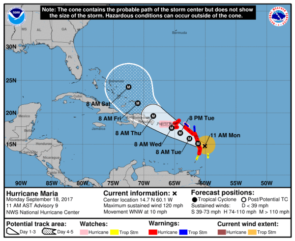
(National
Hurricane Center’s [NHC] projected path and intensity for Maria
shows a major hurricane threatening Puerto Rico over the next two
days. Image source: NHC.)
Maria
is expected to track over very warm Caribbean waters in the range of
84 to 86 degrees Fahrenheit (29+ C) as it enters a favorable
atmospheric environment. And
forecasters now call for Maria to rapidly intensify.
Hurricane watches have already been issued for the American territory
of Puerto Rico. And the present official Hurricane Center track and
forecast intensity for Maria (see above image) shows a severe blow by
a powerful category 4 storm striking somewhere along southeastern
Puerto Rico early Wednesday with maximum sustained winds of 150 mph.
2017
Already a Season for the Record Books
It’s
worth noting that some models presently show Maria tracking north of
Puerto Rico. So the island could still avoid a direct hit. But the
current official consensus is a rather grim forecast.
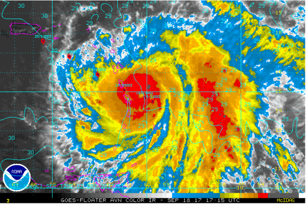
(IR
satellite imagery of Maria shows an increasingly organized storm.
Forecast points and sea surface temperatures included for reference.
Image source: National
Hurricane Center.)
Maria
is the fourth major hurricane to form in the Atlantic during 2017 —
which has been an exceptional season in many respects. This year saw
the early formation of Arlene in
April — only the second named storm recorded to have formed during
that month. It saw the strongest hurricane ever to form outside of
the Carribbean or Gulf of Mexico — Irma —
which was also tied as the strongest land falling hurricane in the
Atlantic. Both Category 4 Harvey and Irma struck the continental U.S.
— the
first time two Cat 4 storms have struck the states in a single month.
And Harvey produced the heaviest recorded rainfall total from a
tropical system at 51.88 inches. Overall damage estimates from the
2017 Atlantic hurricane season presently
stand at 132 billion dollars —
which makes this season the second costliest so far (behind 2005).
How
Climate Change and Other Global Factors Contributed
With
damages from Harvey and Irma still uncounted, with Maria barreling
in, and with a week and a half left to September and all of October
remaining, it’s likely that 2017 will see more to come. Though Irma
and Jose have churned up cooler waters in their wakes, large sections
of the Gulf, Caribbean, and North Atlantic remain considerably warmer
than normal.
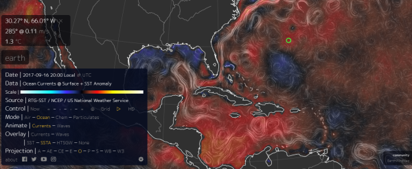
(Sea
surface temperature anomaly map shows that much of the North Atlantic
and Carribbean are between 0.5 and 2 C warmer than the already warmer
than normal 30-year average. Image source: Earth
Nullschool.)
Meanwhile,
a very vigorous Inter-Tropical-Convergence-Zone (ITCZ) is still
producing powerful thunderstorms over Africa. And cool water
upwelling in the Pacific has generated La Nina-like conditions that
tend to cut down on Atlantic wind shear — allowing more storms to
fully develop and tap those warmer than normal waters to reach higher
maximum intensities. Some of these factors — particularly the
warmer than normal surface waters and possibly the increased
intensity of ITCZ thunderstorms are climate change related. So yes,
statements from those like Dr. Michael Mann claiming that this
season’s hurricanes were made worse by climate change are
absolutely valid.
(UPDATES
TO FOLLOW)
RELATED
STATEMENTS AND INFORMATION:
Links:


No comments:
Post a Comment
Note: only a member of this blog may post a comment.