

Storms
of My Grandchildren Rising: Hurricane Amanda Sets Record as Strongest
Eastern Pacific Ocean Cyclone in May
28
May, 2014

Category
5. Only the most powerful of the most powerful storms on Earth reach
this ominous peak. It’s a designation that occurs when hurricanes
achieve a highly destructive wind strength greater than 156 mph.
Usually relegated to late season storms that form and strengthen when
the ocean surface temperature is at its hottest, it is a very, very,
very rare event to see any storm approach Cat 5 status at the start
of hurricane season.
Water
temperatures are typically not high enough to support such a monster
event so early.
But
this Sunday, just six months after the Western Pacific spawned
Typhoon Haiyan, the
most powerful storm ever to strike the land, the three-day-old
hurricane Amanda raged to just shy of Cat 5 status in the Eastern
Pacific.
Peaking at a maximum sustained wind speed of 155 mph, the
storm teetered at the edge of highest intensity category even as it
roared its way into the record books as the mightiest storm ever
recorded for this region of the world in May.

(Hurricane Amanda at strong Category 4 status on May 25. Image source: LANCE-MODIS.)
By
comparison, the storm Amanda beat out, Adolph, was also a rather
recent event, forming on May 25 of 20o1 and reaching a peak intensity
of 145 mph on May 29th.
Hot,
Deep Water
Hurricane
season in the Eastern Pacific starts on May 15. Amanda began to
gather just four days after, as a tropical disturbance, on May 19th.
The storm gradually gained strength as it drifted north and west into
extraordinarily warm waters that ranged from 1 to 3.6 C above typical
temperatures for this time of year. By Sunday, May 25, the storm had
exploded to just shy of category five status.
Extreme
heat intensity fueling Amanda came from a Pacific Ocean exploding
with warmth. The equatorial Pacific was just tipping into the hot
ocean surface event that is El Nino even as overall Pacific anomalies
ranged near 0.8 C above the, already hotter than normal, 1979 to 2000
average. The net result was that Amanda was fueled by sea surface
temperatures in the range of 27 to 30 degrees Celsuis with
hurricane-supporting warmth pushing as far as 50 meters into the
depths. As a result, cool ocean water upwelling through Ekman pumping
had far less effect on this storm than is typical for early in the
season when the sun’s rays usually have not pushed warmth so deep

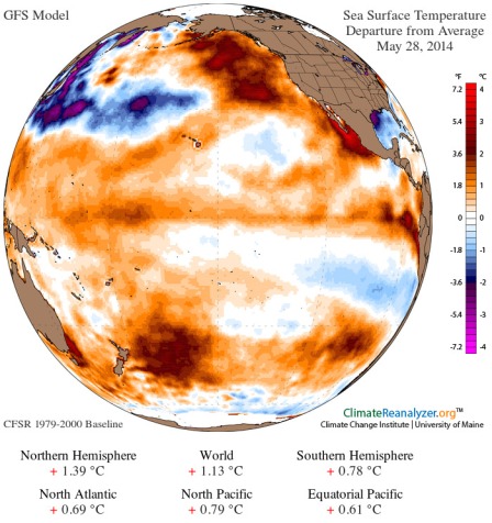
(Today’s
ocean surface temperature anomaly at +1.13 C on May 28th. Global
Ocean surface temperature anomalies have been in the record range of
+1 C above 1979-2000 values all throughout May. Hot ocean surface
temperatures of this kind is hyperfuel for hurricanes. It is no
accident that the record storm that was Amanda formed in the visible
hot pool off the west coast of Mexico. Image source: University
of Maine.)
Hurricanes
are nothing if not ocean heat and moisture engines. The storms feed
on hot air rising off the ocean surface, and their cyclonic action
churns the waters below them eventually limiting their intensity as
the strongest storms dredge into cooler waters. But with human
warming, both the ocean surface as well as the waters far below show
ever increasing heat potentials. This heat is nothing if not
high-efficiency energy for oceanic, warm core cyclones.
Global
Warming Heat Engine — Lengthens Storm Season, Generates More
Powerful Cyclones
Amanda’s
anomalous intensity was, thus, no accident. Instead, it was directly
related to the extreme ocean heating that is an attribute of
human-caused warming. The danger here is not only for more intense
storms and for more intense storms coming earlier and earlier in the
year, it is also for a general lengthening of the period during which
these powerful storms emerge. The risk, therefore, is that hurricane
season will extend deeper into the Spring and further into Fall for
both the Eastern Pacific and the Atlantic. And during this
ever-growing storm year the higher heat values increase the
likelihood of monster storms reaching and exceeding category five
strength.
The
currently explosive Western Pacific may well foreshadow events for
other regions of the world. That volatile storm zone already sees
some seasons featuring year-round hurricanes and tropical storms. And
the already intense cycle there is also likely to strengthen as the
oceans continue to warm.
Links:
.
No comments:
Post a Comment
Note: only a member of this blog may post a comment.