

Monsoon Disrupted By El Nino + Climate Change as India Suffers Deaths, Crop Losses from Extreme Heat.
Robertscribbler,
30 May, 2014
May is the month when the massive rainstorm that is the Asian Monsoon begins to gather and advance. This year, as in many other years, the monsoon gradually formed along the coast of Myanmar early in the month. It sprang forward with gusto reaching the Bay of Bengal by last week.
And
there it has stalled ever since.
On
May 25-27, an outburst of moisture from this stalled monsoonal flow
splashed over the coasts of India. But by the 29th and 30th, these
coastal storms and even the ones gathering over the Bengali waters
had all been snuffed out. The most prominent feature in the MODIS
shot of India today isn’t the rainfall that should be now arriving
along the southeast coast, but the thick and steely-gray pallor of
coal-ash smog trapped under a persistent and oppressive dome of
intense heat.
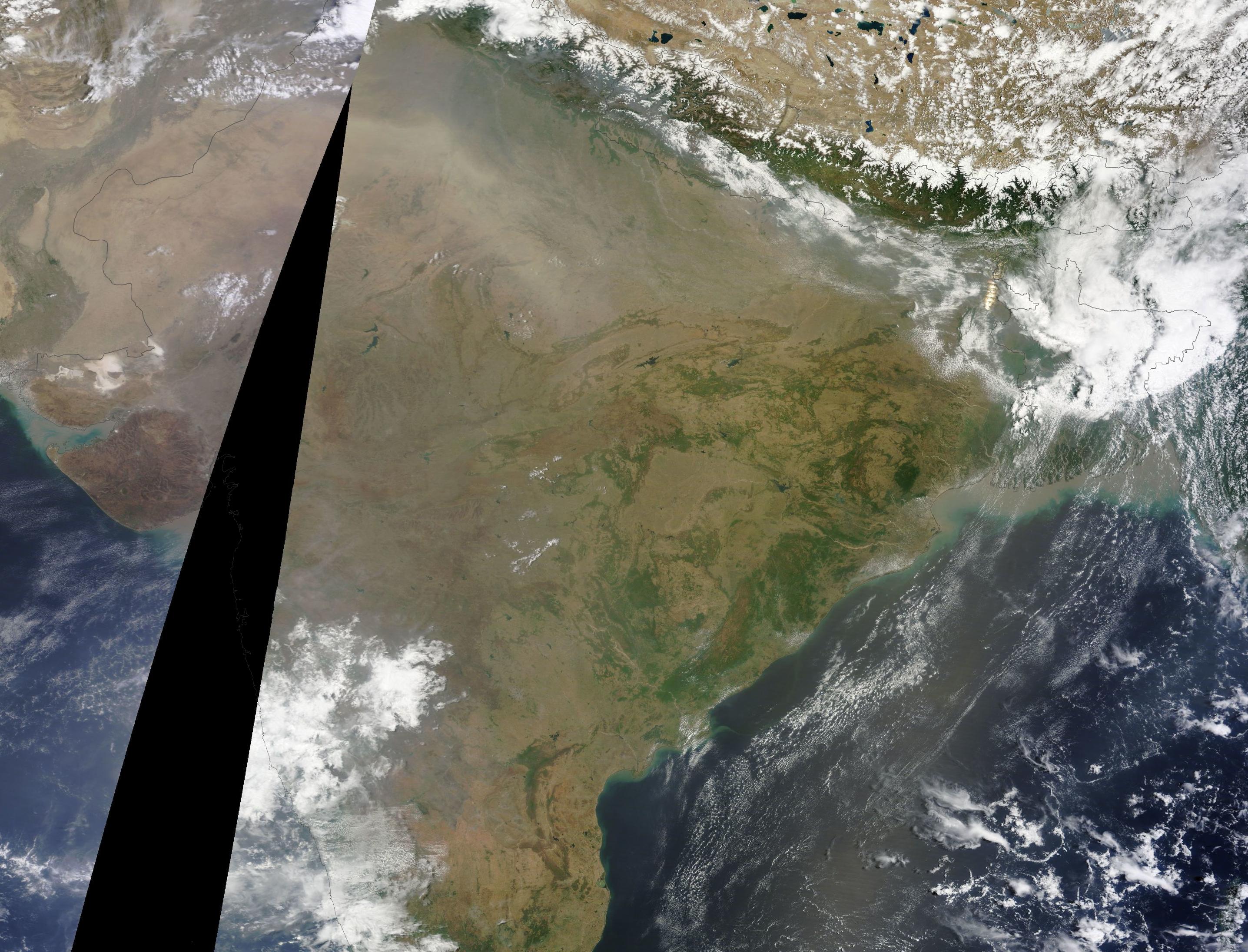
(MODIS shot of India on May 30th. See the open stretch of blue water in the lower right frame? That’s the Bay of Bengal which borders coastal India. During a normal year at this time, that entire ocean zone should be filled with the storm clouds of a building monsoon that is already encroaching on coastal India. Today, there is nothing but a smattering of small and dispersed cloud through a mostly clear sky. Image source: LANCE-MODIS.)
Monsoon
Described as Feeble
Official
forecasts had already announced as of May 27th that the annual
monsoon was likely to be delayed by at least a week for southeast
regions of India. Meanwhile, expected monsoonal rainfall for western
and northern sections of India for 2014 fell increasingly into doubt.
The
monsoon is likely to be delayed by 10 days, according to scientists
at the Indian Institute of Tropical Meteorology (IITM) here. The
IITM’s third experimental real-time forecast says that a feeble
monsoon will reach central India after June 20 as
against the usual June 15. Last year, the monsoon had covered the
entire country by June 15.
The
annual monsoon is key to India’s agriculture. The substantial rains
nurture crops even as they tamp down a powerful heating that
typically builds throughout the sub-continent into early summer.
Without these rains, both heat and drought tend to run rampant,
bringing down crop yields and resulting in severe human losses due to
excessive heat.
But,
this year, heat and drought are already at extreme levels.
Major
Heatwave Already Results in Loss of Life for 2014
As
early as late March, the heatwave began to build over the Indian
subcontinent. The heat surged throughout the state, setting off
fires, resulting in a growing list of heat casualties, shutting down
the power grid and spurring unrest. Meanwhile, impacts to India’s
agriculture were already growing as the Lychee fruit crop was
reported to have suffered a 40% loss.
By
late May, temperatures across a broad region had surged above 105
degrees shattering records as the oppressive and deadly heat
continued to tighten its grip.
In
a country surrounded on three sides by oceans, it is a combination of
heat, humidity and persistently high night-time temperatures that can
be a killer. Wet bulb temperatures surge into a high-risk range for
human mortality during the day even as night-time provides little
respite for already stressed human bodies. Such extreme and
long-duration heat doesn’t come without a sad toll. As of today,
early reports indicated a loss of more than 56 lives due to heat
stroke (In 2012 and 2013, total Indian heat deaths were near 1,000
each year). That said, final figures on heat losses are still pending
awaiting complete reports from all of India’s provinces.
“Climatologically,
we know that heatwaves are increasing in frequency and the number of
days exceeding 45ºC temperatures is increasing. The frequency will
increase further with global warming, hence this is a good example of
a situation where science and disaster management can come together
and avert damage,” a spokesman for India’s National Disaster
Management Authority noted on Friday.
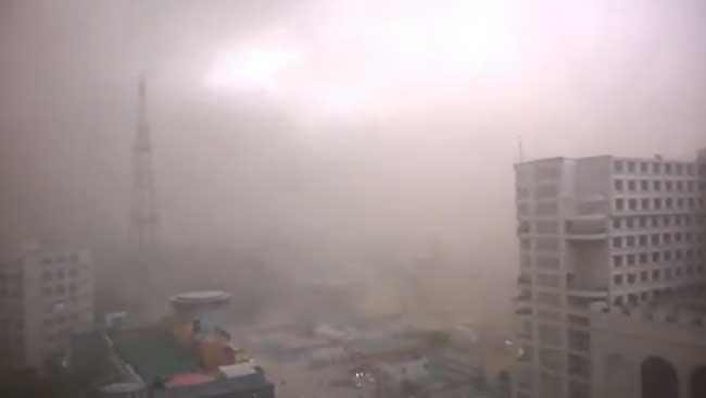
(Hot Dust. A dust storm rolls through New Delhi on Friday amidst furnace-like 113 degree heat snarling traffic and resulting in the tragic loss of 9 more lives. Image source: Gaurav Karoliwal/YouTube Screenshot.)
Today
the heatwave continued to gain ground, with Kota and Rajasthan
reaching an all-time record of 116 degree F (46.5 C) as New Delhi’s
mercury hit 113 degrees F in the midst of a drought-induced dust
storm. Dust shrouding the city spurred traffic chaos and in the heat,
darkness, and confusion nine more souls were lost.
After
two months of growing disruption due to heat and drought, the lands
and peoples of India cry out for a Monsoon that is running later and
later with each new weather report.
Climate
Change + El Nino: Adding Heat and Beating Back the Monsoon
As
systems approach tipping points, they are more likely to tilt toward
the extremes.
For
India this year, its seasonally warmest period from April to May
found severe heat amplification from a number of global factors.
First, climate change seeded the ground for the current Indian
heatwave by adding general heat and evaporation to already hot
conditions. With global average heating of +0.8 C above 1880s levels
amplifying in the hot zones, early moisture loss due to
higher-than-normal temperatures produces a kind of snowball effect
for still more warming. Essentially, the cooling effect of water
evaporation is baked out early allowing for heat to hit harder just
as typical seasonal maximums are reached.

(Equatorial Pacific Ocean temperatures warmed to +0.63 C positive anomaly on May 30th, extending further into El Nino Range. Image source: University of Maine.)
In
addition, this year saw rapid progress toward an El Nino event in the
Pacific Ocean with sea surface temperatures warming into the El Nino
range by mid-May and continuing to ramp higher. By today, Equatorial
Pacific anomalies had hit +0.63 C according to GFS analysis,
extending a run into El Nino conditions.
El
Nino events typically allow for the formation of hot, drier air over
India. These air masses tend to engender extreme heatwaves like the
one we are seeing now even as they delay the onset of cooling
monsoonal rains. In essence, the monsoon is confronted with a heavy
and entrenched wall of hot air that doggedly resists being shoved
aside. And this is the very situation we observe now over India — a
sputtering monsoon to the east getting bullied by a brutally hot and
thick air mass that just won’t give ground. Climate change only
exaggerates the problem by increasing the intensity and inertia of
the hot air mass.
Major
monsoonal disruptions typically occur during years following an El
Nino’s peak heating impact. For example, in 1998, during a period
following an extreme El Nino in the Pacific Ocean, India suffered one
of its most severe droughts and monsoonal delays on record. But
during recent years preceding El Nino, such as 2009, India also saw
severe heat, drying, and crop damage due to a weakening of the annual
summer rains. So an early monsoonal enfeeblement and coincident
strong heatwaves and droughts over India with El Nino still forming
is cause for some concern and bears further monitoring.
Currently,
temperatures over India are surging to between 5 and 12 degrees
Celsius above already hot averages. With heat and drought firmly in
place, forecasts are calling for a 1 to 2 week delay in the cooling
and moisture-bringing monsoon as India continues to swelter.
Links:
(Hat
Tip to Colorado Bob RE Tipping Points)
(Hat
Tip to Mark from New England for Excellent Clarifying Questions)
No comments:
Post a Comment
Note: only a member of this blog may post a comment.