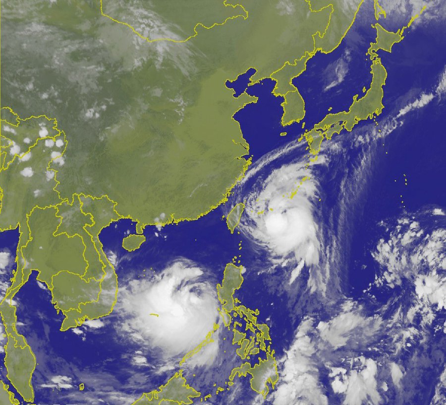
Typhoon Talim veers away from Taiwan, moves towards Japan

TAIPEI
(Reuters) - Taiwan will lift a shipping warning later on Thursday
after Typhoon Talim veered away from the island and moved towards
Japan but the capital, Taipei, and other cities can expect heavy
rains from the storm, meteorologists said.
Some
flight cancellations could also still be expected as northern Taiwan
is lashed by heavy rain.
Talim
had gained in strength since Wednesday as it approached Taiwan’s
northern cities, according to the Central Weather Bureau (CWB), but
it has now shifted north and will not make landfall in Taiwan.
It
also might not hit the Chinese mainland as it veers towards Japan,
the bureau said.
Japan’s
southern Ryukyu Islands have begun to feel the effects, with reports
that strong winds and heavy rainfall have caused power outages as the
typhoon churns in the sea between Taiwan and Japan with maximum
sustained wind speeds at sea of 173 km/h (107 mph) and gusts of up to
209 km/h (130 mph).
The
bureau said bad weather associated with the storm will still be felt
in the north and northeast of Taiwan on Thursday.
“The
effects of Talim have been less severe than many international
weather authorities predicted, including those of us in Taiwan, the
U.S., China and Japan,” said CWB forecaster Wang Chun-hsien.
Talim
had been expected to move towards China, where more than 200,000
people in Fujian and Zhejiang provinces have been evacuated, China’s
official Xinhua news agency said.
The
CWB’s current forecast projected the storm to veer northeast
towards Japan’s western coast. However, it could change course
again.
China
Airlines and EVA Airways, Taiwan’s two largest carriers, said they
would cancel some international flights later on Thursday due to the
storm’s proximity.
Typhoons
are a seasonal routine for Taiwan, but the island has stepped up
preparations since Typhoon Morakat in 2009. Morakat was the deadliest
typhoon to hit the island in recorded history, killing close to 700
people, most in landslides.
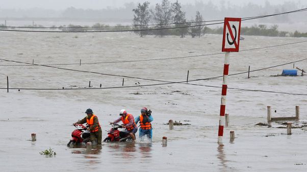
Wind and rain lash Vietnam as Typhoon Doksuri hits

HA
TINH, Vietnam (Reuters) - Typhoon Doksuri lashed central Vietnam on
Friday, tearing roofs from houses, knocking out power and causing
localized flooding, in the country’s most powerful storm in years.
Nearly
80,000 people have been evacuated from coastal regions in preparation
for Doksuri. Winds exceeded 130 km (80 miles) per hour, according to
Vietnam’s meteorological agency.
The
state news agency said the roofs had been blown from 260 houses in
the ancient city of Hue. Electricity was knocked out in parts of Ha
Tinh and Quang Binh provinces after the wind brought down power lines
along with trees and billboards.
Four
fishing boats sank as they were making their way back to land, state
radio said. Many fishermen had dragged their small wooden boats into
the streets of coastal towns to try to stop them from being carried
away.
Streets
in parts of Ha Tinh province were flooded. Airlines said 46 flights
were canceled between the capital, Hanoi, in northern Vietnam and Ho
Chi Minh City, the commercial hub in the south.
Vietnam’s
disaster prevention committee has said the storm surge from Doksuri
could be greater than 2 meters (2.2 yards).
There
were no immediate reports of deaths on Friday, but one person drowned
in central Vietnam on Thursday after flooding caused by heavy rain
that preceded Doksuri.
Vietnam often suffers from destructive storms. Floods in northern Vietnam killed at least 26 people and washed away hundreds of homes in August. Last year, more than 200 people were killed in storms
Typhoon Doksuri Forces 100,000 to Evacuate in Vietnam; Officials Warn Storm Could Be Worst in a Decade
14
September, 2017
As
many as 100,000 residents have been ordered to evacuate their homes
in Vietnam ahead of Typhoon Doksuri, according to local media.
An
offshore fishing ban was issued as the storm got closer to
the Asian nation of 93 million,
Channel News Asia said. Tens of thousands fled Ha Tinh province along
the country's north-central coast, and officials said they would do
anything necessary to move citizens away from the water before the
storm arrived.
"(We)
have to evacuate people resolutely, even forcefully ... to avoid any
casualties when the storm arrives," Vietnam's Deputy Prime
Minister Trinh Dinh Dung said Thursday.
(MORE: Typhoon
Talim a Threat to Japan)
Doksuri
has already been a deadly storm. At least four died and six others
are missing in the Philippines after the typhoon dumped heavy rain
and buffeted
the archipelago with strong winds,
according to the New York Times. After the storm struck the
Philippines, dozens of flights were canceled in central Vietnam and
the evacuations of residents in Ha Tinh and Quang Binh were ordered,
the report added.
Authorities
have told residents to expect heavy
rain, flooding and
landslides from the storm,
according to the Bangkok Post. Doksuri is expected to make landfall
Friday, the Vietnamese national weather forecast center told the
Associated Press. Officials issued a category four "danger"
warning – the second-highest warning level – and said the storm
could be the worst to hit the country in a decade, Channel News Asia
also reported.
"We
have prepared sandbags to put on the roof so when the storm arrives
it won't be blown off," Ha Tinh resident Nguyen Thi Que told
state-controlled news site Zing.
Vietnam
also put 250,000 soldiers on standby ahead of Doksuri, Channel News
Asia said.
It
has been a deadly year for severe weather in Vietnam; some 140 people
have been killed or remain missing as a result of flooding and other
extreme weather, the report added.
Meanwhile on the other side of the Pacific
Meanwhile on the other side of the Pacific
Hurricane Max weakens rapidly over southern Mexico
14
September, 2017
Hurricane
Max slammed into Mexico's southern Pacific coast Thursday, dumping
rain on an area east of the resort city of Acapulco before rapidly
weakening into a tropical storm as it moved inland into Guerrero
state.
The
coastline where Max made landfall is sparsely populated and dotted
with fishing villages.
Guerrero
Gov. Hector Astudillo warned that the rains would continue all night.
Near Acapulco, the government worked frantically to widen a channel
to the sea to prevent a coastal lagoon from flooding.
The
U.S. National Hurricane Center had earlier issued a hurricane warning
for the coastline between Zihuatanejo and Punta Maldonado, and said
the storm could bring "life-threatening flash floods and
rainfall" to Guerrero and Oaxaca states.
The
center said the rapidly weakening Max should become a tropical
depression in the coming hours before dissipating early Friday.
Max
had maximum sustained winds of 45 mph (70 kph) and was located about
80 miles (130 kilometers) east of Acapulco Thursday night. It was
heading toward the east at 7 mph (11 kph), the hurricane center
reported.
Acapulco,
about 30 miles (60 kilometers) from where the hurricane made
landfall, was hit by strong winds and rain that blew down some
branches on the city's coastal boulevard.
Also
Thursday, Tropical Storm Norma formed farther out to the west in the
Pacific and was expected to strengthen and head toward the
resort-studded Baja California Peninsula.
Norma
was located about 360 miles (580 kilometers) south of the twin
resorts of Los Cabos at the peninsula's southern tip.
The
storm had winds of 45 mph (75 kph) and was moving north at 6 mph (9
kph). On that track Norma could be at hurricane strength near Los
Cabos by Sunday or Monday.
Los
Cabos was hit by Tropical Storm Lidia in early September, causing at
least five deaths.


No comments:
Post a Comment
Note: only a member of this blog may post a comment.