Subtropical Storm Alex Forms in the Atlantic — Sets Path Toward Greenland
“We
must begin to move now toward the era beyond fossil fuels. Continued
growth of greenhouse gas emissions for just another decade
practically eliminates the possibility of near-term return of
atmospheric composition beneath the tipping level for catastrophic
effect.”
*****
13
January, 2015
We
should have listened to Dr. James Hansen back in 2008. Now, nearly 8
years later, human greenhouse gas emissions have continued to grow
even as freakish extreme weather events have multiplied across the
globe. It’s all too clear now that atmospheric composition is well
within the range that produces freakish, and even catastrophic
effects of the kind Hansen alluded to.
Today, on January 13 of 2016, it happened. As of 5:00 PM Eastern
Standard time, we have a named subtropical storm Alex raging in the
North Atlantic just west of the Azores. In the Central Pacific, Pali
has reached hurricane strength and is now setting a course that will
bring it very close to the Equator.
Alex
is only the fourth named storm ever to have formed during January in
the North Atlantic (since record keeping began in 1771). But Alex is
an odd event for a number of other reasons — not the least of which
being that it formed at the same time that another unprecedented
storm — Pali — had hit hurricane status in the Central Pacific.
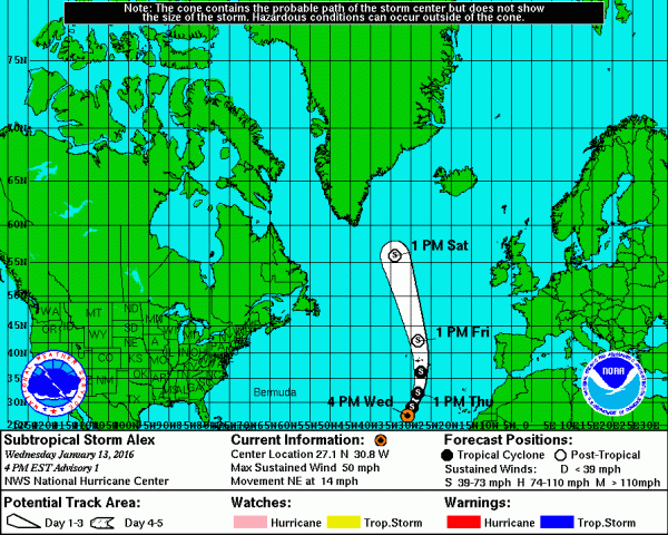
As we ring in the New Year with record to near-record warm temperatures over much of Earth’s oceans, we are confronted with something that would have been unimaginable a few decades ago: simultaneous January named storms in both the Atlantic and Central Pacific. The earliest named storm on record in the Central Pacific, Hurricane Pali, formed on January 7, and now the Atlantic has joined the early-season hurricane party, with Subtropical Storm Alex spinning up into history with 50 mph winds in the waters about 785 miles south-southwest of the Azores Islands. The average date of the first named storm in the Atlantic is July 9; the Central Pacific also typically sees its first named storm in July.
(Alex’s
projected path brings it just off Greenland by Saturday. A winter
subtropical cyclone aiming its heat-engine fury directly at the
Arctic. You couldn’t write science fiction that was more bizzarre.
Image source: NOAA.)
Like
a cold-seeking missile of atmospheric heat, Alex is predicted to aim
itself directly at the Arctic. A summer-time storm forming in Winter
and projected to deliver its heat energy to the environment of the
far North Atlantic just south of Greenland by this weekend. The storm
is predicted to retain subtropical characteristics even as it
approaches Greenland by late Friday. Another extraordinary projection
of tropical heat and moisture into the Northern Latitudes during a
Winter in which the season seems to be anything but.
Instead,
we seem to have this strange hybrid of winter, spring and summer. In
which hurricanes form during January in the Northern Hemisphere. In
which the North Pole sees above freezing temperatures. And in which
many regions keep flashing between warm and cold conditions even as
the threat for extreme storms abounds. As Hansen warned nearly a
decade ago — we are tipping into more and more catastrophic
conditions. And we should listen to Hansen and put every policy in
place possible to “to move now toward the era beyond fossil fuels.”
Sadly,
we didn’t move fast enough 8 years ago to prevent some of the
catastrophic effects of human-forced climate change from being locked
in. But we can at least now move decisively to prevent the very worst
impacts. All too sadly, though, it appears the storms that Hansen
predicted for our grandchildren may well have started to arrive
early.
Links:
Off-Season
North Atlantic Hurricanes
Hat
Tip to Redsky
Hat
Tip to Colorado Bob
Hat
Tip to DT Lange
Hat
Tip to Griffin


No comments:
Post a Comment
Note: only a member of this blog may post a comment.