More Signs of Winter Arctic Melt — Icebergs are Showing up off Newfoundland in January
21
January, 2015
From
pole to pole the ice is melting. Winter is retreating. And much of
life and even the seasons themselves appear to have been thrown
off-kilter. In the Southern Ocean near the Antarctic Peninsula, krill
populations have dropped by more than 50 percent due to a shortening
of the season in which sea ice forms. The
North Pole now experiences near or above freezing temperature events
during Winter with increasing frequency. Greenland
appears to be undergoing melt episodes during Winter.
And now, the iceberg season for Newfoundland is starting four months
early.
******
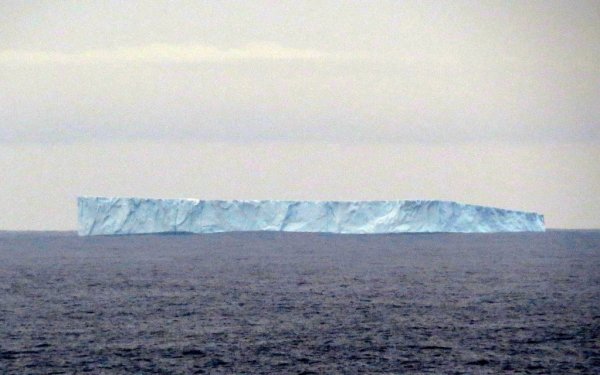
(This
iceberg was spotted off the coast of Bonavista, Newfoundland on
January 20, 2016. It’s the first iceberg of the year for
Newfoundland. One that is appearing four months earlier than the
typical iceberg season for this part of the world. Image
source: Iceberg
Spotter.)
During
any normal year in the 20th Century, Newfoundland was a prime spot
for viewing icebergs. Locked away in the sea ice for much of the
Winter, these behemoths became liberated with the spring thaw. By
April or May, they could at first be seen off the coast of
Newfoundland as they made their trek out into the Atlantic Ocean
along the currents running away from Baffin Bay and the West Coast of
Greenland.
During
a normal year, the sea ice begins its thaw in Baffin Bay along
Greenland’s western coastal boundary by early to late April. A
milder air flow along the northward progressing warm water current is
enough to unlock some of the icebergs stranded within the sea ice and
to send them cycling southward toward Newfoundland.
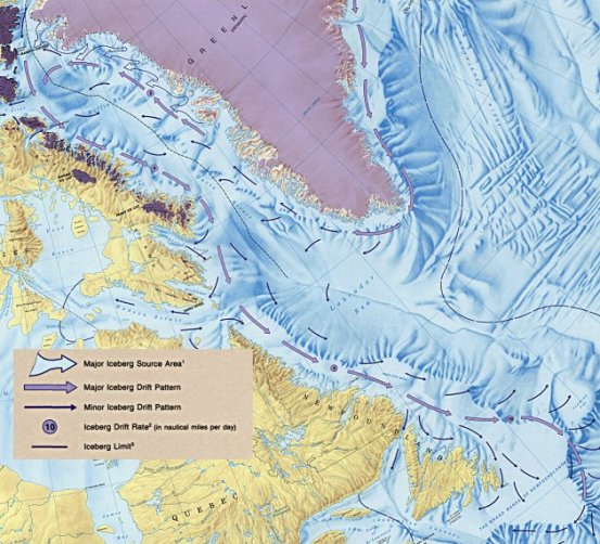
(Icebergs
typically originate from Greenland’s west coast and then cycle
around Baffin Bay. Icebergs sighted off Newfoundland typically break
away from the Baffin ice pack during Spring. This year, one got free
of the ice in January. Image source: The
Atlas of Canada.)
But
this year, something odd and rather strange happened. During mid
January, following
a December in which Arctic sea ice extents were their fourth lowest
on record,
a period of unseasonable warmth settled in over Western Greenland.
Warm, wet winds blew up over Greenland’s coastal mountain ranges
and into Baffin Bay. These winds were ushered northward by both a
very powerful North Atlantic storm track and by an anomalously warm
termination of the Gulf Stream Current just south and east of
Newfoundland.
By
late last week, the
remnants of a January Atlantic hurricane had been pulled into this
warm storm generation zone just south of Greenland where
it eventually unspooled over the frozen isle’s mountains even as it
vented the last remainder of its fury on the iceberg outlets of
Baffin Bay.
(Warm,
tropical moisture associated with Hurricane Alex is pulled northward
into Greenland and Baffin Bay in mid January. This heat and moist air
delivery, associated with northward propagating warm winds along
Western Greenland, appears to have had multiple wintertime melt
impacts for this region of the Arctic. Video source: Hurricane
Alex Transitioning to Post-Tropical.)
And
all this heat and tropical weather aimed at Greenland and Baffin Bay
during January appears to have had a pretty far-ranging impact. For
not only have melt monitors over the Greenland Ice Sheet picked up a
Winter melt signal. Not only has Disko and Uummannaq Bay been flushed
clear of sea ice during Winter.
Now, just a few days later, we see the first iceberg of a four month early start to typical iceberg season for Newfoundland. Yet one more well out of season impact during a Winter that really isn’t like any Winter that could be considered normal — at least for what human beings or the living creatures of this world are used to.
Now, just a few days later, we see the first iceberg of a four month early start to typical iceberg season for Newfoundland. Yet one more well out of season impact during a Winter that really isn’t like any Winter that could be considered normal — at least for what human beings or the living creatures of this world are used to.
Links:
Hat
Tip to Colorado Bob
Hat
Tip to Catherine Simpson


No comments:
Post a Comment
Note: only a member of this blog may post a comment.