Swells and Rough Surf from Jose Heading to U.S. East Coast

|
|
|
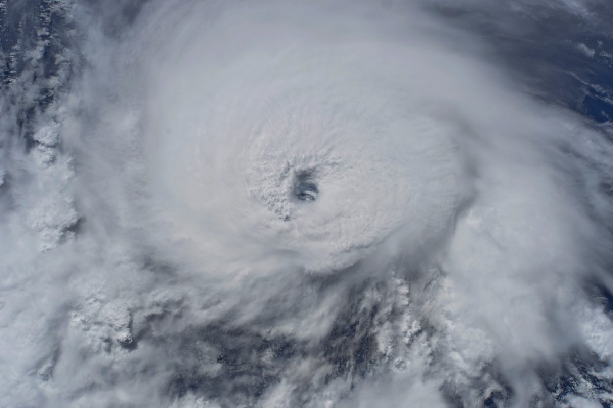
Above:
Visible GOES-16 image of Jose at 1605Z (12:05 pm EDT) Thursday,
September 14, 2017. GOES-16 images are preliminary and
non-operational. Image credit: RAMMB
/ CIRA@CSU. |
Tropical Storm Jose is predicted to restrengthen into a hurricane and arc just off the east coast of U.S. and Canada early next week. Chances are slim that the storm will make landfall, but it’s a good bet that coastal communities from the mid-Atlantic to the Canadian Maritimes will feel Jose’s presence. Meanwhile, there are four other potential landfalls across the North Pacific from Vietnam to Mexico over the next 3-5 days.
Jose
was downgraded to a 70-mph tropical storm at 11
am EDT Thursday after
more than a week at hurricane strength, peaking as a strong Category
4. Jose was located about 520 miles south-southwest of Bermuda,
heading west-northwest at 7 mph. Relentless northerly shear of 20-25
knots has taken its toll on Jose, despite very warm sea-surface
temperatures along its path (29-30°C or 84-86°F). The northerly
winds have also lowered the mid-level relative humidity in Jose’s
environment to around 50%, which is quite low for sustaining a
hurricane. Even so, Jose has managed to maintain a surprisingly
intense core of showers and thunderstorms (convection), as evident in
Figure 1 below. Wind shear is predicted to drop to around 15 knots on
Thursday night into Friday, and this may be just enough to allow Jose
to regain hurricane strength, as predicted by NHC. Chances of any
dramatic or rapid intensification are quite low, but Jose is expected
to maintain Category 1 hurricane strength into early next week. Wind
shear will again be on the increase next week, and it seems likely
that Jose will take on more of the characteristics of a large
mid-latitude storm over time.....
Hurricane
Jose May Wander Off the U.S. Coast For Over a Week
Dr.
Jeff Masters

September
13, 2017, 11:04 AM EDT
Above:
GOES-16 view of Hurricane Jose at 10:15 am EDT September 13, 2017.
Image credit: NOAA/RAMMB. GOES-16 data is considered preliminary and
non-operational.
Hurricane
Jose is continuing its leisurely loop over the waters a few hundred
miles north of Puerto Rico, and is not expected to threaten any land
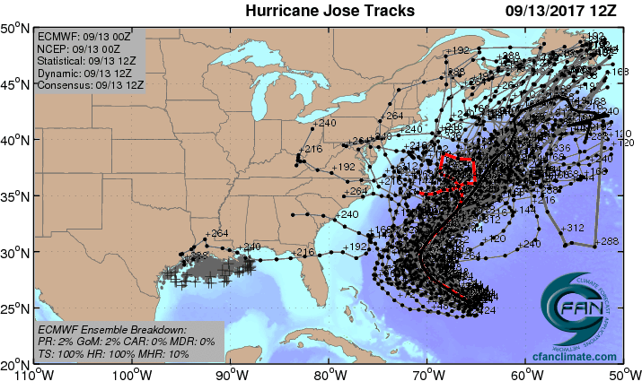
areas this week. The latest computer models now say that Jose may be
with us a very long time--at least another week. Jose may be a
landfall threat next week for the U.S. East Coast or Canada, but that
is too far in the future to make a reliable forecast. Bermuda is near
the edge of Jose’s 5-day cone of uncertainty, and residents of that
island should monitor the storm.
A walk inside the Eye of #Jose. Just amazing to see through the eye to the surface!
Intensity
forecast for Jose
Jose
is under high wind shear of 20 - 30 knots, and high shear is expected
to affect Jose all week, keeping it a Category 1 hurricane or
tropical storm. Satellite images on Wednesday morning showed that
Jose still had plenty of intense heavy thunderstorm activity, but the
storm was misshapen and asymmetrical due to the high wind shear.
Passage over its own cold wake in the ocean may be able to weaken
Jose to a tropical storm by Friday. After crossing its cold wake,
Jose will be over very warm waters with sea surface temperatures
(SSTs) near 29.5°C (85°F). These warm waters extend all the way to
the coast of North Carolina.
Jose
forecast
 |
Figure
1. The 20 track forecasts for Jose from the 0Z Wednesday, September
13, 2017 GFS model ensemble forecast. The majority of the solutions
resulted in no landfall, though 6 of 20 did predict an eventual U.S.
landfall. Image credit: CFAN.
Jose
forecast
 |
Figure
2. The 0Z Wednesday September 13, 2017, track forecast by the
operational European model for Jose (red line, adjusted by CFAN using
a proprietary technique that accounts for storm movement since 0Z
Wednesday), along with the track of the average of the 50 members of
the European model ensemble (heavy black line), and the track
forecasts from all 50 members of the ensemble. The majority of the
forecasts keep Jose offshore, with the operational version of the
model predicting that Jose will perform another loop. Image credit:
CFAN.
Track
forecast for Jose
There
are two big stories today in the track forecast for Jose. Number one
is the shift by the UKMET model forecast towards what the rest of the
models were predicting—a motion towards the north by Jose on Friday
and Saturday, which would keep Jose from making landfall in the U.S.
this week. The normally reliable UKMET model had been predicting a
Florida landfall late this week, and it is good to see the model
going away from that outcome. The other big story is the new
consensus among our long-range models that Jose will potentially be
around for a long time—a week or longer.
On
Wednesday morning, Jose was headed southeast at 7 mph, and was in the
midst of a slow clockwise loop that it will complete by Thursday
evening. (Such loops are uncommon, but not unheard of--in 2004,
Hurricane Ivan did a much larger clockwise loop that resulted in two
U.S. landfalls.) The slow, looping path Jose is taking in an area of
weak steering currents is the sort of behavior that our computer
models don’t predict with a high degree of accuracy, and the 5-day
error in the latest track forecast is likely to be higher than
average.
A
high-pressure system will build in to the northeast of Jose late this
week, and will begin steering the hurricane to the northwest and then
north, between North Carolina and Bermuda, over the weekend. After
that, the future track of the storm gets very murky. Jose will be in
an area of weak steering currents next week in the waters several
hundred miles southeast of New England, and may wander erratically
off the coast all week. The large waves from the storm will be
capable of causing high surf and considerable beach erosion along the
shores of the mid-Atlantic and New England coasts during this period.
Water temperatures within about 400 miles of the coast, from New
Jersey to Maine, are generally below 26°C (79°F), which will make
it difficult for Jose to intensify, fortunately. Bottom line: It’s
too soon to know what Jose will do, and the storm is likely to be
around for a week or longer.
 |
Infrared
satellite image of NE Pacific, 15Z 9/13/2017
Figure
3. Infrared satellite image of TD 15E and TD 16E in the eastern
Pacific as of 1500Z (11 am EDT) Wednesday, September 13, 2017. Image
credit: NASA/MSFC Earth Science Branch.
The
first new tropical cyclones in two weeks in Eastern Pacific
While
Harvey, Irma, and Jose raged across the Atlantic over the last three
weeks, it’s been relatively quiet over the Eastern Pacific. This
has changed with the formation of Tropical Depression 15E on Tuesday
night and Tropical Depression 16E on Wednesday morning. TD 15E is the
first tropical cyclone to form in the eastern Pacific since TD 14
formed on August 30 and became Tropical Storm Lidia the next day. Our
last East Pacific hurricane was Kenneth, which peaked as a Category 4
on August 21.
Of
our two new depressions, the immediate concern is TD 16E, located
about 130 miles west-southwest of Acapulco as of 11 am EDT Wednesday.
TD 16E is already moving north-northeast at 5 mph with a rich swath
of moisture and widespread but relatively weak thunderstorm activity
(convection). Conditions are favorable for development, but TD 16E
hasn’t much time: it will be arcing into the Mexican coastline not
far from Acapulco on Thursday, most likely still at depression
strength. Rainfall of 5 – 10” is expected as TD 16E pushes
inland, with higher localized totals possible.
Meanwhile,
TD 15E was moving west through the open tropical Pacific about 900
miles southwest of Cabo San Lucas, Mexico, as of 11 am EDT Wednesday.
The depression is poorly organized, and moderate wind shear of about
15 knots is hindering its growth, but its convection increased
notably on Tuesday night. The 12Z Wednesday run of the SHIPS model
indicates that shear across TD 15E will drop below 10 knots on
Thursday and will remain light into the weekend. Since TD 15E will be
over warm enough water to support development (27-28°F or 81-82°C),
it has a shot at becoming a tropical storm as it continues west. Out
top models have been producing only modest development of TD 15, but
the 06Z run of the HWRF model intensifies the depression into a
hurricane by this weekend. If so, TD 15E will need to produce a core
soon enough to fend off the effects of increasingly dry air around
it. In any event, TD 15E poses no threat to land.
In
between 15E and 16E, we have yet another disturbance, dubbed Invest
95E, embedded in the same swath of moist air that favors development.
Wind shear should remain light to moderate (around 10 knots) over the
next couple of days as 95E travels over very warm waters (SSTs of
29-30°C or 84-86°F). The wind shear will be increasing by this
weekend, but it is possible 95E will become a tropical storm before
that point. In its tropical weather outlook issued at 8 am EDT
Wednesday, NHC gave 95E a 60% chance of developing into at least a
depression by Friday, and an 80% chance by Monday.
Why
does the East Pacific often go quiet while the Atlantic lights up,
and vice versa?
What
goes up must come down, and it’s often the case that when
conditions favor rising air and hurricane formation in the Atlantic,
we have sinking air and reduced hurricane activity in the East
Pacific. This is especially common during La Niña events, but it can
also occur when the El Niño/Southern Oscillation (ENSO) is in its
neutral mode. On the other hand, during El Niño, subsidence and
increased wind shear become more common across the Atlantic,
typically reducing hurricane activity there. Forecasters raised their
predictions of an active Atlantic hurricane season this spring and
summer when it became apparent that no El Niño would develop. Dr.
Phil Klotzbach explained the process in an August post for the NOAA
ENSO Blog.

ENSO
effects on hurricanes
Figure
4. Typical effects of El Niño abd La Niña on hurricanes across the
Eastern Pacific and Atlantic. Image credit: NOAA Climate.gov, based
on originals by Gerry Bell.
While
ENSO is officially in a neutral mode right now (NOAA’s Michelle
L’Heureux called it “extreme neutral” in August), there has
since been substantial cooling of the eastern tropical Pacific. This
is in conjunction with the upwelling part of a Kelvin wave (a weak
but large disturbance that moves slowly east across the uppermost
waters of the tropical Pacific). The latest weekly value of the
Niño3.4 index is -0.6°C, which suggests enough cooling to qualify
as La Niña conditions if it were to persist for a few months. Most
global models in August were predicting a neutral winter for 2017-18,
but the most recent runs of NOAA’s CFSv2 model strongly suggest
that we are already in the onset phase of a La Niña event. As of
mid-September, climate prediction models from the Australian Bureau
of Meteorology (BOM) and MeteoFrance agree with CFSv2 that La Niña
conditions will expand into early 2017-18. (This is based on NOAA’s
definition of La Niña, which is less stringent than BOM’s.) Four
other global models were still calling for a neutral 2017-18.
 |
ENSO
forecast
Figure
5. ENSO outlook from NOAA’s Climate Forecast System, version 2
(CFSv2) as of Sept. 10, 2017. The graph at left shows sea-surface
temperatures across the Niño3.4 region of the eastern tropical
Pacific, as predicted by the CFSv2 model ensemble (thin lines) and
the model mean (black dashed line). Readings below -0.5°C are
associated with La Niña, so the CFSv2 favors La Niña development
for 2017-18, as shown in the sea-surface temperatures maps at right.
Image credit: NOAA/NWS/CPC.


No comments:
Post a Comment
Note: only a member of this blog may post a comment.