Climate Change and El Nino Locked in Tempestuous Embrace — Teleconnection Between Hot Equatorial Pacific and North Atlantic Cool Pool?
3
January, 2016
The
troubled and tempestuous North Atlantic. It’s a place where the
most ominous kinds of atmospheric bombs just keep going off. From the
Cumbria floods — the worst seen since at least the Middle Ages —
to the 300-year-old bridge wrecking Frank, to above-freezing
temperatures at the North Pole during Winter, weather features
throughout this region have increasingly taken on the ugly markings
of systems twisted by the hand of human-forced warming.
One
issue that’s been raised is what, if any, influence El Nino might
have had on this most oddly extreme North Atlantic weather? There,
such anomalous storms are more than likely the off-shoots of three
new features related to climate change. One is a Stefan
Ramhstorf-identified
cool pool of water just south of Greenland. A freakish region of
colder than normal sea surfaces that is, all-too-likely, the result
of increased glacial melt outflows from a heat-harrowed Greenland. A
second climate change related feature is a zone of very hot water
along the Gulf Stream off the US East Coast. This odd warmth is
likely due to a kind of Gulf Stream train wreck caused by the
blocking lid of fresh water Greenland melt has thrown over that
current’s driving circulation. So as the zone south of Greenland
cools, the area just off the Eastern Seaboard heats up. A third and
final feature is a polar warming related heating of the Barents sea
surface along with a related massacre of sea ice in that previously
frozen region.
These
three features have radically altered the heat and moisture exchange
patterns of the North Atlantic and are all too likely the primary
factors involved in the crazy increase in extreme weather we’ve
seen there during 2013, 2014, and 2015.
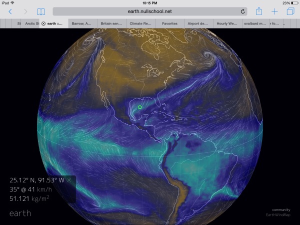
(Teleconnection
between El Nino and the three freak weather patterns in the North
Atlantic? River of moisture running up from the El Nino heat bleed in
the Eastern Equatorial Pacific all the way to a storm forming in the
North Atlantic cool pool just south of Greenland on January 1 of
2016. Note the above image is a graphical measure of total
precipitable water content. Image source: Earth
Nullschool.)
But
one factor that has been somewhat murky is what, if any, influence a
near record or record El Nino may be having on the weather bombs
going off over this climate change hotspot? At issue is the fact that
teleconnections — or atmospheric energy and moisture exchange —
between El Nino and the North Atlantic are somewhat difficult to
tease out in the model essays and observational data.
However,
this year, there does appear to be quite a lot of heat and moisture
issuing from the monster El Nino raging in the Equatorial Pacific.
For one, the record rains over South Carolina and the Central United
States this year are certainly tied to an extremely heavy flood of
moisture coming from this major atmospheric and ocean event. The
moisture bleed has originated from the Eastern Pacific, lofted over
Mexico and Central America to saturate airs over the Gulf States, the
Central and Eastern US.
Recent
observational data, in addition, also hints that this extraordinary
moisture flow may well be linking up with another major moisture
bleed off of sea surfaces in the range of 5-7 degrees Celsius above
average off the US East Coast before feeding directly into the storm
bombification zone over the North Atlantic cool pool.
(River
of moisture sets up between Equatorial Pacific and North Atlantic on
January 1 of 2016. Image source: LANCE
MODIS.)
It’s
initial observational evidence that may well be the answer to a
question we’ve been asking in the forum here since summer time —
could such a teleconnection set up between these two ocean surface
temperature anomaly features? In other words, could we be seeing a
link up between El Nino and features that are all-too likely related
to climate change resulting in some extraordinarily severe weather?
Well, on January 1, as identified by the cracker-jack spotting of
Andy in San Diego, the atmosphere appeared to present a very strong
tell-tale of just such a link up between moisture flows.
In
the above NASA MODIS satellite shot we find what appears to be an
atmospheric river of moisture running along a cloud pattern issuing
from the Eastern Equatorial Pacific, across Mexico and the Southern
US, out over the raging hot waters off the US East Coast and finally
terminating in the North Atlantic cool pool zone east of Newfoundland
and just south of Greenland.
If
this is indeed what’s happening, then what we’re seeing is El
Nino enhancing an already extremely intense North Atlantic storm
generation pattern that is all-too-likely related to climate change.
An El Nino + Climate Change teleconnection between the Pacific
Equator, the North Atlantic, and, earlier
this week, the North Pole that’s
about just as unprecedented as all the never-before-seen weather we
experienced during 2015. Something that could well turn weather
forecasting as we know it on its ear.
In
any case, something to look for in the post event reports on this,
very disruptive, El Nino and possibly related North Atlantic extreme
weather.
Links:
Hat
Tip to Andy in San Diego (fantastic spotting!)


No comments:
Post a Comment
Note: only a member of this blog may post a comment.