Showing posts with label Pacific. Show all posts

Saturday, 28 December 2019

James Renwick takes a guess on a blob to the east of New Zealand


Note: This is from foreign media.

Scientists are "puzzled" once again and the scientist at Victoria University who I think will give any explanation  to justify his "easy-does-it" approach to climate change thinks it is due to "more sun"and "less wind".

“It’s just a patch of water that’s had a lot of sunny skies and not much wind”.

These people take a description and call it a "cause"

No wind???

Our part of the world is still one of the windiest on the planet.

***
I have been reporting on a hot blob in the Tasman Sea for the last 3 years. During that period it never went away and only dissipated over the last year.


I was observing and reporting on this LONG BEFORE the authorities who only mentioned it when it was too obvious to be ignored while always reporting in a way that understated the phenomenon (I am talking of NZ's NIWA, the equivalent of NOAA.


Lots of sun?


Hot blob: vast patch of warm 

water off New Zealand coast 

puzzles scientists

Area of water in the Pacific Ocean off NZ is 6C hotter than normal, possibly due to a lack of wind in the region
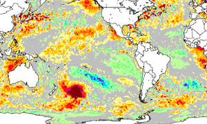
The hot blob off the NZ coast, seen here as a patch of dark red east of New Zealand
27 December, 2019


A spike in water temperature of up to 6C above average across a massive patch of ocean east of New Zealand is likely to have been caused by an “anti-cyclone” weather system, a leading scientist says.

Appearing on heat maps as a deep red blob, the patch spans at least a million square kilometres – an area nearly 1.5 times the size of Texas, or four times larger than New Zealand – in the Pacific Ocean.

James Renwick, the head of geography, environment and earth sciences at Victoria University in Wellington, said the scale of the temperature spike near the sparsely populated Chatham Islands archipelago was remarkable, and had been building for weeks.

It’s the biggest patch of above average warming on the planet right now. Normally the temperatures there are about 15C, at the moment they are about 20C,” he said.


Renwick said the blob could be linked to rising atmospheric greenhouse gas emissions, as a result of climate change, but he expected it was overwhelmingly due to natural variability – a strong high pressure system and a lack of wind.

It’s not uncommon to see patches of warmer water off New Zealand but this magnitude of four, five, up to six degrees is pretty unusual,” Renwick said.

It’s probably a very thin layer of ocean that has warmed up and there hasn’t been any wind to cool it for several weeks.”

Anti-cyclones form when a mass of air cools, contracts and becomes more dense, increasing the weight of the atmosphere and the surface air pressure.

Renwick said a surge in ocean heat over a short period could be difficult for local marine life if it penetrated far beyond the surface. Ocean temperatures are less prone to sharp changes than those on land due to the amount of energy required to warm an area of water.


He said scientists would study the spike in coming weeks to gain more insight into its cause and local impact. It followed a marine heatwave two summers ago that propelled New Zealand’s hottest summer on record, more than 3C above average, and led to tropical fish from Australia being found along the country’s coast.

(Ed.This was NOT a one-off blob that came and went as described here but was here for at least 2 years and has only dissipated in the last few months)

Across the globe, the World Meteorological Organisation says the last decade has almost certainly been the hottest on record for land and oceans. Seas have also grown more acidic as they have absorbed carbon dioxide from the atmosphere.

Temperatures for the years 2010 to 2019 were about 1.1C above the average for the pre-industrial period. The preliminary findings of the WMO’s annual state of the global climate report released earlier this month found this year was likely to be the second or third warmest since records began.


https://www.news.com.au/technology/environment/weird-hot-blob-appears-near-new-zealand/news-story/e5c53fe3eeb0796a86328b064731eb29

From NZ media - this IN FULL from Pravda NZ Inc (AKA RNZ)


Marine heatwave pushes temperatures 5C above normal

RNZ,
28 December, 2019


A marine heatwave measuring almost one million square kilometres has been detected off the east coast of New Zealand.

The heatwave has pushed the ocean temperature up by about 5C above the normal temperature of 15C.

The large blob was identified by thermal imaging from the US National Oceanic and Atmospheric Administration.

Victoria University Professor of Physical Geography James Renwick said the heatwave was likely to be caused by warm northerly winds and extended periods of sunshine.

Dr Renwick said, while heatwaves were not unusual, they were happening more often due to the global warming.

He also said marine life was likely to be affected.

Last summer, a marine heatwave around New Zealand waters led to hot, stuffy air temperatures across much of the country, and scientists observed sub-tropical fish swimming far further south.

This time round, it doesn't appear the ocean heat will have much impact on land temperatures, as the currents are moving towards South America.


From not quite a year ago. The only cause of concern seems to be about fish life because it was a "one-off" affair as it was the year before that, and the year before that as it is this year.


The Tasman Sea warmed on average by 3.7C above normal to reach 20.6C, with fish normally found in the tropics straying further south than they are supposed to.


University of Otago physical oceanographer Dr Robert Smith said while this may be good for recreational fishers, it pointed to the disruption of ecosystems that could be devastating to some species.


Thursday, 17 January 2019

Revisiting Fukushima

Time to revisit a slow-moving extinction event

FUKUSHIMA Update 2018 (IT'S ALL DEAD!) 


WatchmanReview
We don't hear much about Fukushima, do we? There is good reason for the media to ignore it. Join me as we look at the Fukushima nuclear disaster...then to now. The truth needs told, and it's scarier than you can imagine.

Tuesday, 10 July 2018

Orcas are starving in the Pacific Northwest


I suspect there are as many lies and omissions in this as there is truth. One cause – radiation from Fukushima – is taboo.

Orcas of the Pacific Northwest Are Starving and Disappearing


9 July, 2018

SEATTLE — For the last three years, not one calf has been born to the dwindling pods of black-and-white killer whales spouting geysers of mist off the coast in the Pacific Northwest.

Normally four or five calves would be born each year among this fairly unique urban population of whales — pods named J, K and L. But most recently, the number of orcas here has dwindled to just 75, a 30-year-low in what seems to be an inexorable, perplexing decline.

Listed as endangered since 2005, the orcas are essentially starving, as their primary prey, the Chinook, or king salmon, are dying off. Just last month, another one of the Southern Resident killer whales — one nicknamed “Crewser” that hadn’t been seen since last November — was presumed dead by the Center for Whale Research.

In March, Gov. Jay Inslee issued an executive order directing state agencies to do more to protect the whales, and in May he convened the Southern Resident Orca Task Force, a group of state, tribal, provincial and federal officials, to devise ways to stem the loss of the beloved regional creature. “I believe we have orcas in our soul in this state,” he said. At another point, he wrote of the whales and Chinook salmon that “the impacts of letting these two species disappear would be felt for generations.”

SEATTLE — For the last three years, not one calf has been born to the dwindling pods of black-and-white killer whales spouting geysers of mist off the coast in the Pacific Northwest.

Normally four or five calves would be born each year among this fairly unique urban population of whales — pods named J, K and L. But most recently, the number of orcas here has dwindled to just 75, a 30-year-low in what seems to be an inexorable, perplexing decline.

Listed as endangered since 2005, the orcas are essentially starving, as their primary prey, the Chinook, or king salmon, are dying off. Just last month, another one of the Southern Resident killer whales — one nicknamed “Crewser” that hadn’t been seen since last November — was presumed dead by the Center for Whale Research.

In March, Gov. Jay Inslee issued an executive order directing state agencies to do more to protect the whales, and in May he convened the Southern Resident Orca Task Force, a group of state, tribal, provincial and federal officials, to devise ways to stem the loss of the beloved regional creature. “I believe we have orcas in our soul in this state,” he said. At another point, he wrote of the whales and Chinook salmon that “the impacts of letting these two species disappear would be felt for generations.”

Much is still unknown about the plight of these orcas, but biologists and conservation managers have zeroed in on several main factors — and they are all connected.

The biggest contributing factor may be the disappearance of big king salmon — fish more than 40 inches long. “They are Chinook salmon specialists,” said Brad Hanson, team leader for recovery efforts for the Northwest Fisheries Science Center here, part of NOAA. “If they could, they would eat Chinook salmon 24/7.” Orcas gobble 30 a day. Hunting enough smaller prey requires a lot more energy.

The underwater world in the region is also getting noisier, especially an area between the San Juan Islands and Vancouver Island called Haro Strait. It is one of the orcas’ favorite foraging grounds in the summer.

It’s also essentially a big rock ditch where sound bounces off. When you add in commercial vessel traffic going to Vancouver, recreational boaters and whale watching operations, it’s a pretty noisy place,” Mr. Hanson said.

Researchers are studying noise there now. They believe the cacophony of ship traffic interferes with echolocation and makes it harder for the whales to locate their prey and to communicate prey location among themselves. It can also cause hearing loss.

In recent years, officials have expanded the distance which vessels, including whale watching boats and kayaks, must keep from the whales. And there is a voluntary no-go zone near the San Juan Islands.

Just the presence of boats can cause the whales to spend less time feeding,” said Lynne Barre, of NOAA Fisheries, recovery coordinator for the orcas. “And it’s harder to communicate. They have to call longer and louder when boats are nearby.”

Another factor is the pollution in Puget Sound. Whales that live off the coast of Seattle, Tacoma and other cities are effectively urban whales buffeted by municipal and industrial waste, and the occasional spillage from wastewater treatment plants into the ocean. Killer whales carry some of the highest levels of pollution of any marine animal.

Of most concern are the lingering effects of chemicals and pesticides, including the now banned DDT, as well as PCBs and PPDE, widely used in flame retardants and found through the world. The pollutants accumulate in salmon as they feed, and when the whales eat salmon they also ingest PCBs at even higher levels.

It’s very lipophilic, which means it stays in the fat, and the females transfer a huge proportion of the contaminant burden to their offspring,” Dr. Hanson said. “About 85 percent gets transferred to calves through lactation.”

And while much of the pollution is from the region’s industrial past, Boeing disclosed this spring that over the past five years it had discharged highly toxic PCBs into the Duwamish River, which flows into Puget Sound, thousands of times over the legal limit.

These toxins suppress the whales’ immune systems, making them more susceptible to disease. They can also impede reproduction. That may be why tests show a high number of females who have become pregnant have failed to calve.

However, the decline of the whales can’t be pegged, experts say, to contaminants alone. A separate population of transient whales near here eat mammals that eat fish, and so consume concentrate contaminants at even higher levels — many times as high as the resident pods. Yet they are thriving, which has left scientists scratching their heads. Global populations are robust as well.

One possible scenario is that the dearth of salmon coupled with the interference of engine noise, which can affect their immune system, too, deprives the orcas of a sufficient diet. Their bodies then draw on fat reserves, which are laced with chemicals that suppress their immune system and reduce fecundity.

But experts aren’t sure what is raising their mortality rate. Often, when whales die, their carcasses sink or wash up onto remote beaches and are hard to find and test.

In recent years, researchers have been focusing on anthroponeses, diseases that humans may be passing to wildlife. Scientists have sailed out among the pods with a petri dish at the end of a 25-foot long pole to pass through the mist that whales exhale and see what they carry in their lungs. They found a range of pathogens that could be from humans, including antibiotic resistant bacteria and staphylococcus, which can cause pneumonia.

It doesn’t mean they are sick, we don’t have evidence for that,” said Linda D. Rhodes, a research biologist expert in marine microbes and toxins and part of the study. “It means they are being exposed. Whether or not the whales get sick is a product of how much of it is present in the environment and how well is the whale able to defend itself.”

There is deep concern that a fatal human or animal disease has, or will, cross the species barrier and find its way into these immuno-compromised killer whales. “I’ve had dreams about it at night,” said Joseph K. Gaydos, a veterinarian with the SeaDoc Society in Eastsound, Washington in the San Juan Islands, who studies the southern residents. “Disease smolders in the environment but can break out. If there were a highly virulent virus to come through here it would take out a large part of the population and totally stop recovery efforts.”

Disease threats are myriad. A young killer whale died from a fungal infection last year. Toxoplasmosis is a disease spread by parasites in the feces of cats. It is one of the top threats to the Hawaiian monk seal, killing eight of the remaining 1,400 since 2001. It’s not known, though, to affect whales.

Canine distemper from dogs is also a concern. It’s a morbillivirus, which is an RNA rather than a DNA virus. Some 1,500 dolphins were killed by a single outbreak of morbilliviruses on the East Coast several years ago.

RNA viruses can mutate rapidly and cross species lines,” Dr. Gaydos said.

Steps are being planned to help the whales persevere. More Chinook salmon are being reared in hatcheries as whale food, but that is far from a certain fix.

In the end trying to maintain a population of whales in the shadow of one of the fastest growing cities in the country may not be possible.

It’s an ecosystem-wide problem,” Dr. Hanson said. “Things are out of whack and we have to get them back to where we can sustain killer whales. And the clock is ticking.”

Losing the charismatic, intelligent animals with the distinctive black-and-white “paint job” and permanent smile would be a blow to the area.

There would be a great sense of loss,” Dr. Rhodes said. “They are such a part of our identity here. It would be a real sense of failure.”


Friday, 22 June 2018

Could the Hot Pacific Blob Become Permanent

How Arctic Sea Ice Loss Could Make the Hot Pacific Blob Permanent 


21 June, 2018

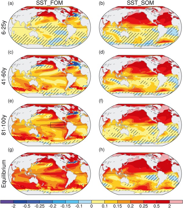
From the North Pacific to the tropics, loss of sea ice will result in a vastly heated Pacific Ocean in which events like the recent Hot Blob become far more common. Those were the conclusions of a new model study conducted by Wang, Deser, Sun and Tomas and recently published in Geophysical Research Letters.


(Understanding how sea ice loss in the Arctic can result in large-scale Pacific warming.)

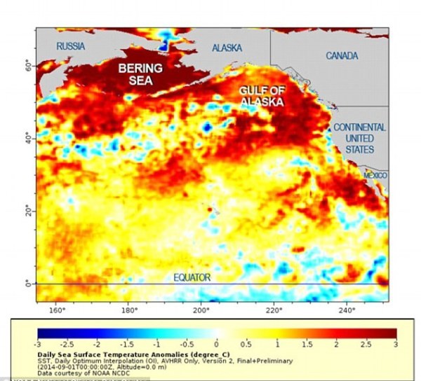
An ocean heating event called the Blob resulted in mass loss of sea life during the period of 2013-2014. It was associated with a towering high pressure ridge in which the upper level winds ran far to the north and into the Arctic. Beneath the ridge, temperatures both at the land and ocean surface grew to be much warmer than normal.

Though viewed as a fluke by some, many began to draw connections between the powerful ridge feature, the related Pacific warming, and sea ice loss in the Arctic. Now, a new scientific study using climate models has produced some rather telling findings. First, the study found that Arctic sea ice loss results in large scale Pacific Ocean warming within just 10-20 years of widespread Arctic Ocean ice reductions

Second, the study models indicated that warming occurred first and strongest in the North Pacific, but then rapidly translated toward the Equator.
(Sea surface temperatures across the North Pacific were much warmer than normal during the hot Blob event of 2013-2014. A new model study finds that sea ice loss will make such extreme events common.)

The reason for this change in planetary and Pacific Ocean energy balance is scientifically described as a teleconnection. In very basic terms, loss of sea ice at the Arctic Ocean surface produces changes in local wind patterns that ripple through the global atmosphere. After a rather short period of time, wind patterns in the upper levels of the atmosphere and at the surface in the Pacific Ocean become involved.

Winds are often the vehicle by which energy is transferred throughout the atmosphere and at the surface. So a change in winds, from the top of the atmosphere to the bottom, can swiftly translate to a change in surface temperatures.

(A new model study shows radical changes in Pacific sea surface temperatures in response to Arctic Ocean sea ice loss.)

Looking at the study, it appears more likely now that the Northern Pacific Hot Blob of 2013-2014 was not a fluke, but instead an early knock-on effect of Arctic sea ice loss. A kind of event that will tend to become commonplace as the Arctic Ocean ice continues to melt. And that eventually, sooner rather than later, the heat build-up in the North Pacific will translate south to the Equator. First warming the Eastern Pacific in a more persistent El Nino type pattern and then spreading west (see image above).

As with the Blob, everything from the health of sea life to the intensity of extreme weather would be substantially impacted by such large scale changes. In other words, it looks like large scale losses of Arctic sea ice are enough to affect a broad and disruptive change in the global climate regime.


Wednesday, 6 June 2018

The garbage patch in the Pacific Ocean is three times the size of France


The Great Pacific Garbage Patch Is Growing

And it was already enormous


27 March, 2018

What’s 1.6 million square kilometers, weighs 80,000 metric tons, and is three times the size of continental France?

That would be the Great Pacific Garbage Patch—the enormous collection of detritus that floats in the Pacific Ocean, halfway between Hawaii and California. Also known as the “GPGP,” the patch’s sprawl has made it notoriously difficult to measure. But a new study published last Thursday in the journal Scientific Reports has gathered the most comprehensive measurement yet. After three years of data collection, researchers from the Ocean Cleanup—a Dutch nonprofit that works on developing technologies to scrub the oceans—have calculated that the patch is four to sixteen times larger than ever before determined—and it’s growing.

This plastic accumulation rate inside the GPGP, which was greater than in the surrounding waters, indicates that the inflow of plastic into the patch continues to exceed the outflow,” Laurent Lebreton, the lead author of the study, told Science Daily.

Since scientists started measuring the patch in the 1970s, they have typically used fine-meshed nets to trawl the accumulation zone. But these nets are not large enough to capture clusters of bigger garbage. To overcome this problem, the researchers outfitted a C-130 Hercules aircraft with LiDAR sensors—the same kind used by self-driving cars—to take 3D scans of the garbage, allowing them to capture images of both floating and submerged trash, as well as very large pieces of plastic, such as meters-wide fishing nets. Using this method, the researchers counted 1.8 trillion pieces of plastic floating in the accumulation zone, and collected 1.2 million plastic samples that they brought back to the lab to study, one by one.

When they did, they learned something new about the makeup of the patch. The GPGP it is neither a giant floating island of garbage—as was widely believed back in the 90s—nor a massive swirl of confetti-sized pieces of plastic, as has been widely reported since. Instead, it’s what Mother Nature Network’s Russell McLendon has called a “galaxy of garbage,” composed of a network of plastic, large and small. A full 92 percent of the mass is comprised of larger objects, while only 8 percent is made up of “microplastics”—fragments smaller than 5 millimeters.

We were surprised by the amount of large plastic objects we encountered,” Julia Reisser, chief scientist of the expeditions, told Science Daily. “We used to think most of the debris consists of small fragments, but this new analysis shines a new light on the scope of the debris.”

But how did the patch get here in the first place, and why is it getting bigger? In short: human thoughtlessness and fluid mechanics. Over the years, five large mega-gyres—that is, great whirlpools where currents collide—in the North and South Atlantic, the North and South Pacific, and the Indian Ocean have become filled with garbage. A plastic cup tossed on a San Francisco street will wend its way to the sea via storm drain, and then journey to the nearest gyre, where it will join trillions of other artifacts of human civilization.


This plastic pollution isn’t just unsightly: It poses threats to marine life and it has health and economic implications for humans as well. According to the Ocean Cleanup, oceanic plastics enter the human food chain through a process called bioaccumulation, in which the chemicals in plastic can enter the bodies of sea life like fish and then later, the bodies of the predators who consume those fish. There’s a significant economic impact, too: The UN has reported that ocean plastic pollution costs $13 billion every year through the likes of beach cleanups and financial loss incurred by fisheries.

Dead whale found in Thailand with 17 pounds of plastic in its stomach


Volunteers and marine veterinarians from Department of Marine and Coastal Resources attempted to rescue a sick male pilot whale in the coastal area of southern Thailand near the Malaysian border, 28 May 2018. Photo: ThaiWhales / AFP / Getty Images

3 June, 2018

BANGKOK, 3 June 2018 (Reuters) – Some 80 pieces of plastic rubbish weighing 17 pounds were found in the stomach of a whale that died in Thailand after a five-day effort to save it, a marine official said on Sunday.

The pilot whale was discovered on Monday in a canal in the southern province of Songkhla and received treatment from a team of veterinarians.

The whale spit out five plastic bags on Friday and later died, the Marine and Coastal Resources Department said on its website.

An autopsy found another 80 bags and other plastic items weighing more than 17 pounds (8 kg) in the whale’s stomach.

This plastic rubbish made the whale sick and unable to hunt for food,” the department said.

Jatuporn Buruspat, head of the department, said the whale probably thought the floating plastic bags were food. […]


A government marine veterinarian is being helped by volunteers to remove plastics from the stomach of dead male pilot whale at the Marine and Coastal Resource Research and Development Center in Songkla province, Thailand, 1 June 2018. Photo: ThaiWhales / AFP / Getty Images

Globally, eight million tons of plastic — bottles, packaging and other waste — are dumped into the ocean every year, killing marine life and entering the human food chain, the United Nations Environment Programme said in December. [more]


Tuesday, 3 October 2017

The evacuation of Vanuatu

Vanuatu launches a Dunkirk-style evacuation on the northern island of Ambae as a flotilla of boats rescues islanders from an erupting volcano.

Photo AFP

3 October, 2017

Vanuatu has launched a Dunkirk-style evacuation on the northern island of Ambae as a flotilla of boats rescues islanders from an erupting volcano.

The eruption has polluted many of the island's water sources leaving thousands of people in need of safe drinking water, Red Cross delegate Joe Cropp told Reuters by phone on Sunday.

"Water is crucial," he said.

"It's important to get on top of it right away."

The Manaro Voui volcano, the nation's largest, was seen hurling steam and rocks into the air by New Zealand vulcanologist Brad Scott who flew over the volcano on Saturday.

"Maybe about every 8 to 10 seconds there was an explosion, throwing lava bombs up maybe 50 to 100 meters above the crater and there's also two small lava flows that are flowing across the island into the lake as well," he said in an interview with Radio NZ published on Sunday.

Crowds of islanders from at least three evacuation points on the island have begun boarding a flotilla of ships including ferries, canoes and commercial vessels for the safety of surrounding islands Maewo, Pentecost and Santo.

The Vanuatu Government wants all 11,000 islanders evacuated by Oct. 6.
Australia sent amphibious Bay Class landing ship HMAS Choules on Saturday to help move the population, and it is expected to arrive by the middle of the week.

Some islanders are flying out while others have already moved to stay with friends or relatives in the capital, Port Vila. More than 6000 people have gone to emergency shelters on the South Pacific island in preparation for the total evacuation.

Manaro Voui stirred to life in September, threatening island residents with burning ash, toxic gas and acid rain.

The volcano is crowned by crater lakes.

One of them, Lake Voui, is directly on top of the eruption making it dangerously explosive and posing the deadly threat of a lahar: a boiling mud flow down the side of the mountain, Macquarie University vulcanologist Christopher Firth told Reuters by telephone on Saturday.