Robbertscribbler ("Mr. Scribbler") and his latest article rate a mention in this latest article. Weather
chaos makes the Australian mainstream.
'Bomb
cyclone' to spike Arctic temperatures, add to UK's flooding woes
29
December 2015
The
ferocious storm cell that spawned deadly tornadoes in the US over the
weekend is expected to develop into what meteorologists call a
"bomb cyclone", steering exceptionally warm air over the
Arctic and more flooding rains into the UK.
One
widely used computer model, the Global Forecast System, is predicting
the storm to drop pressure levels sharply by Tuesday night, easily
exceeding the "bomb cyclone" criteria of at least 24
millibars in 24 hours, according to the Washington
Post's Capital Weather Gang.
"We've
probably never seen weather like what's being predicted for a vast
region stretching from the North Atlantic to the North Pole and on
into the broader Arctic this coming week," said Robert
Scribbler, an
environmental blogger.
A
massive storm off Greenland is likely to hammer Iceland and parts of
Britain. Photo:
Null School
Mr
Scribbler said the storm, now to the south of Greenland, is likely to
link up to two other powerful low pressure systems in the North
Atlantic, creating a "truly extreme storm system".
"The
Icelandic coast and near off-shore regions are expected to see heavy
precipitation hurled over the island by 90 to 100 mile (144-161km)
per hour or stronger winds raging out of 35-40 foot (10.7-12.2m) seas
," he said. "Meanwhile, the UK will find itself in the
grips of an extraordinarily strong southerly gale running over the
backs of 30-foot swells."
The
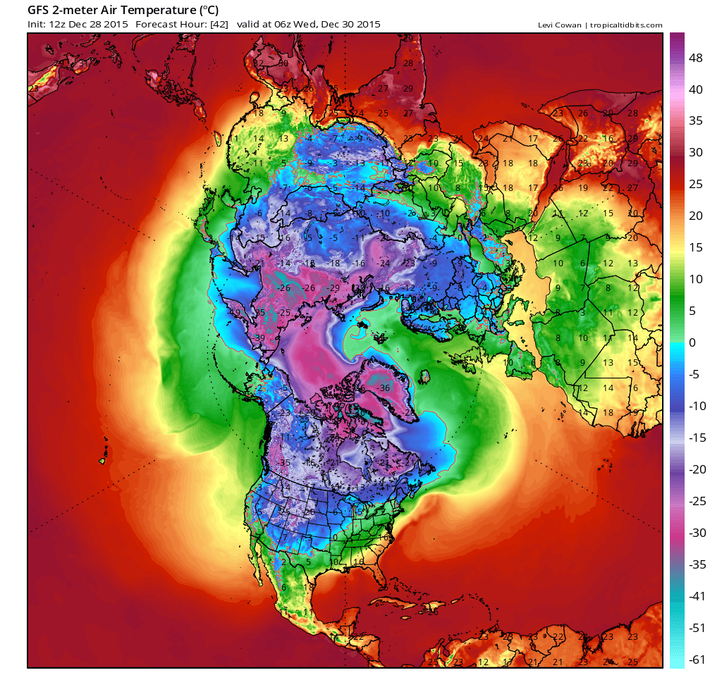
storm will also drag warm air over the high Arctic. with the North
Pole temperatures likely to climb to 1-2 degrees above zero on
Wednesday - or 41-42 degrees above average for this time of year, Mr
Scribber said:
Rescue
teams evacuate residents the UK city of York - with more flooding
possible this week. Photo:
Getty Images
"Needless
to say, a 1-2 [degree] reading at the North Pole during late December
is about as odd as witnessing Hell freezing over," Mr Scribbler
wrote. "But, in this case, the latest wave of warmth issuing
from a human-driven shift toward climatological hell appears to be on
schedule to arrive at the North Pole in just a few more days."
Meteorologists
debated the extent of the abnormal Arctic warmth, with some saying
the divergence would be closer to 30 degrees above the average for
the North Pole at this time of year - but still a remarkable
temperature spike.
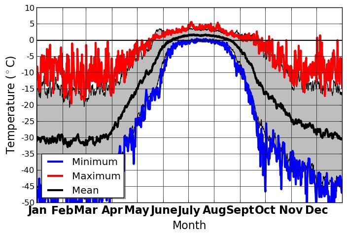
How many NPole readings > 32°F? None Jan-Mar but 3 in Dec, per NCEP/NCAR reanalysis 1948-2014 (Steven Cavallo, OU)
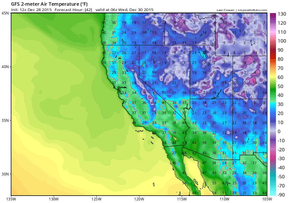
The
North Pole, shrouded in darkness at this time of year, is likely to
be warmer than regions of southern California, Oklahoma and Texas,
according to US meteorologist Eric Holthaus:
Temps at the North Pole should be near 40°F on Wednesday, warmer than OKC, El Paso, and southern California.
While
meteorologists and climatologists will likely debate for some time
the specific climate change contribution to the weather across much
of the Northern Hemisphere this month, scientists have long known
that the atmosphere can hold about 7 per cent more moisture for each
degree of warming, potentially leading to more energetic storms.
The
planet is about 1 degree warmer than pre-industrial times. Almost 200
nations vowed at this month's Paris climate summit to work to keep
temperatures increases to "well below 2 degrees".
Cleaning
up and preparing for more
For
now, though, the focus is likely to containing or repairing the
damage from tornadoes that have left at least 40 people dead in the
US, while hundreds of river gauges are reporting some flooding.
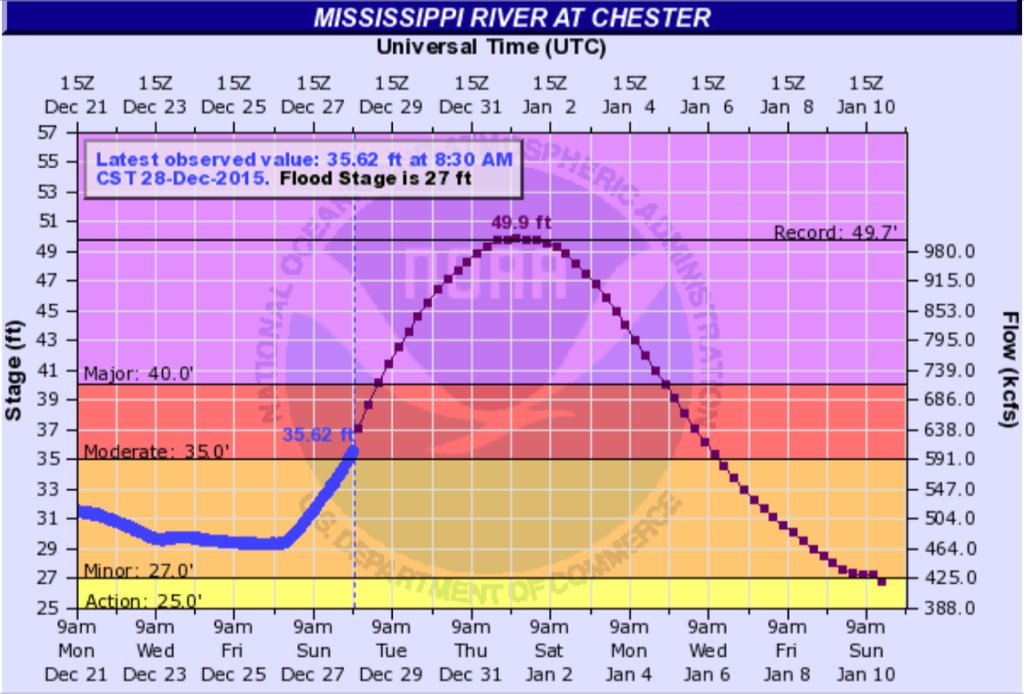
This is insane. You don't expect peak Mississippi River flooding in early winter.
The
UK's Met Office is expecting more heavy rain to come from what it
dubs Storm Frank.
Areas
recently hit by flooding, such as Cumbria in northern England, may
cop a further 100-150mm of rain, the Met
Office said.
"We
expect stormy conditions to return midweek, and have already
issued National
Severe Weather Warnings for
gales on Tuesday and heavy rain on Wednesday, as a rapidly deepening
area of low pressure, Storm Frank, passes to the northwest of the
UK," Will Lang, the Met Office's chief meteorologist,
said.
"Everyone
should be aware of the potential for disruption in places from
further flooding and the impacts of the gales to transport,
especially in areas such as southern and central Scotland and Cumbria
where amber 'be prepared' warnings are in place."
The
Met Office notes that occasionally storm weather "is not unusual
for this time of year", and the that UK was hit by a similar
strength storm in the 2013-14 winter.
Even so, the widespread flooding has prompted renewed debate in the UK over the impacts of climate change and whether the government is doing enough to prepare for it.
Meteorologists,
meanwhile, have used terms such as "cyclone bombs" or
"meteorological bombs" since 1980 to storms that originate
in the tropics and bring sudden, severe drops in air pressure. The
four regions of the world where such explosive
cyclonic events are most active are
the north-west and south-west Pacific, and the North and
South Atlantic.
"It's
as if a bomb went off. And, in fact, it did," said Jason Samenow
of the Capital Weather Gang, about this week's event. "The
exploding storm acts a remarkably efficient heat engine, drawing warm
air from the tropics to the top of the Earth."


 Bob Henson


 Eric Holthaus


 Eric Fisher


No comments:
Post a Comment
Note: only a member of this blog may post a comment.