

Northern
Territory floods: woman dies, hundreds evacuated and saltwater crocs
in town
Woman’s
car was caught in flood east of Katherine, while almost 500 residents
of Nauiyu have been evacuated and crocodiles roam the community

27 December, 2015
A
woman has died after her car got caught in Northern Territory floods
that have forced the evacuation of hundreds of people and brought
saltwater crocodiles into remote communities.
A
police helicopter spotted the vehicle in floodwaters about 4km from
the remote Beswick community, east of Katherine, on Sunday night. It
is believed the elderly woman was one of five people in the car.
 Nine News Sydney
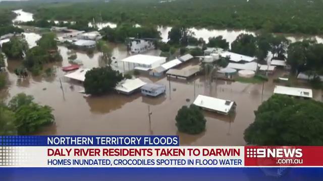
Hundreds of residents from Northern Territory town of Daly River airlifted to Darwin after severe flooding. #9News


“This
is the second person who has been washed away in a flooded creek
since Christmas,” NT police, fire and emergency commander Bruce
Porter said.
“Again
I urge people to avoid taking unnecessary risks on the roads and
avoid driving into floodways.”
Hopes
were fading in the search for a 28-year-old man missing from
Peppimenarti in the Daly River region since Christmas Day.
Residents
of the remote Nauiyu community – also known as Daly River –
reported saltwater crocodiles had made their way into town in the
floodwaters. The crocodiles were seen on the local football field and
the NT News reported one had been seen taking two dogs.
Submerged street signs in
the community of Nauiyu in the Northern Territory, where crocodiles
were seen on the local football field.
Submerged street signs in
the community of Nauiyu in the Northern Territory, where crocodiles
were seen on the local football field. Photograph: Stuart
Brisbane/Daly River Barr Resort
Stuart
Brisbane, owner-operator of the Daly River Barra Resort, said he had
seen a large croc “swimming past the paddock about 50-80 metres
away” from the resort.
The
stories you need to read, in one handy email
Read more
Almost
470 people have been evacuated by helicopter from Nauiyu since an
evacuation order was issued on Boxing Day. They were transported more
than 150km to Batchelor where an evacuation centre had been
established, before being bussed to Darwin.
Nauiyu
resident Nadine Maloney told the ABC adults took turns watching the
water rise overnight as it approached the doorstops of houses.
Brisbane
said the flood was the second highest of the three he had experienced
in the 10 years he had lived there.
“We
normally like floods because the bigger the wet the better the
fishing’s going to be,” said Brisbane, who had not been
evacuated.
Brisbane’s
family home and the fishing resort’s holiday accommodation sit on
high ground and the water had not reached any buildings, but they
were cut off from all road access, he told Guardian Australia.
“We
just sit here and watch the world go by. We can get out by boat if we
want to,” he said.
“I
said to my wife this morning, at least we didn’t have to spend
$15-20m dollars to get our own island.”
The
floodwaters had reached the bottom of the property and as a
precaution against the saltwater crocodiles, he had locked up his
dogs.
“We
were sitting on the verandah last night having a couple of bevvies
with a mate and there was one swimming past the paddock about 50-80
metres away. It was quite a big one,” Brisbane said.
On
Sunday Brisbane took his boat into the now evacuated Daly River
community, about 6km away. He said some houses, the medical centre
and the water treatment facility had all escaped flooding, but many
other houses were partially submerged.
“We’ve
seen a couple of police boats there keeping an eye on the place where
there’s no one there,” he said.
Nadine Daly and her
family from the remote Nauiyu community on the Daly River spent
Saturday night in Darwin’s Foskey Pavilion after being evacuated
due to floodwaters.
Nadine Daly and her
family from the remote Nauiyu community on the Daly River spent
Saturday night in Darwin’s Foskey Pavilion after being evacuated
due to floodwaters. Photograph: Avani Dias/ABC News
Severe
thunderstorms, heavy rain and winds were forecast for areas including
Katherine on Monday, as a tropical low pressure system moved across
the state towards Queensland.
There
was still the chance of a cyclone in the Gulf of Carpentaria, experts
said.
About
134mm of rain had fallen in the Daly Waters region in the 24 hours to
9am on Monday. The Bureau of Meteorology issued a severe weather
warning for the Daly, Tiwi, Arnhem, Carpentaria, Gregory, Barkly and
Simpson areas, with fears of flash flooding.
Abnormally
high tides and heavy surf were forecast for coastal areas. Residents
in affected areas have been warned to take precautions.
“Create
your own sandbags if there is flooding by using pillow cases or
shopping bags filled with sand and place them around doorways to
protect your home,” the latest BoM warning advised.
Emergency
kits should also be ready with a battery-operated radio, torch, spare
batteries and first aid kits.
Police
advised motorists to take extra precautions.
“I
continue to urge everyone to exercise extreme caution on the roads
and to consider the necessity of their travel plans,” Porter said.
“The last thing we want is for anyone to become an unnecessary
statistic.”
Dozens
killed as wild weather sweeps across southern and central US
- At least 43 people have been killed in Christmas weekend storms
- State of emergency declared in Missouri and New Mexico
- Tornadoes rip through Dallas area, killing 11 people
- Another 13 die in Illinois and Missouri flash flooding

27
December, 2015
At
least 43 people have been killed after storms hit southern and
central US states over the Christmas holiday, unleashing floods and
tornadoes, flattening buildings, blowing vehicles off highways and
snarling transportation for millions.
The
weather prompted the governors of Missouri and New Mexico to declare
a state of emergency for their states on Sunday.
In
the Dallas area, 11 people were left dead by tornadoes over the
weekend, including one packing winds of up to 200 miles per hour (322
kmh). The twister hit the city of Garland, killing eight people and
blowing vehicles off highways.
“A
tornado of that strength is very rare in a metropolitan area,”
National Weather Service meteorologist Matt Bishop told Reuters.
Powerful tornadoes are a staple of spring and summer in central
states but occur less frequently in winter, according to U.S. weather
data.
“It
is total devastation,” Garland police spokesman Lieutenant Pedro
Barineau said. “It is a very difficult time to be struck by such a
horrible storm the day after Christmas.”
It
was the latest of a succession of powerful weather events across the
country, from heavy snow in New Mexico, west Texas and the Oklahoma
panhandle to flash flooding in parts of the plains and midwest.
In
addition to the Texas fatalities, flash flooding killed at least 13
people in Illinois and Missouri, officials and local media reported
on Sunday.
Six
adults drowned when they drove their cars into flooded waterways in
Missouri’s Pulaski county, said county sheriff Ron Long.
In
neighboring Illinois, Salem-based radio station WJBD reported a
family of three adults and two children was driving near the village
of Patoka, 85 miles (137 km)east of St. Louis, Missouri, when their
car was washed away by floodwaters.
The
death toll in the south-east linked to severe weather rose to 19 on
Sunday when Alabama authorities found the body of a 22-year-old man
whose vehicle was swept away while attempting to cross a bridge; a
five-year-old died in the same incident. Ten people have died in
Mississippi, and six died in Tennessee. One person was killed in
Arkansas.
The
full extent of damage along a nearly 40-mile stretch near Dallas was
becoming clear Sunday: houses destroyed, vehicles mangled, power
lines down and trees toppled. Heavy rain and wind hampered cleanup
efforts on Sunday afternoon.
The
weather service said an EF-4 tornado, which is the second-most
powerful with winds up to more than 200mph, hit the community at
about 6.45pm on Saturday. It was near the intersection of Interstate
30 and George Bush Turnpike, which is a major route in the region. At
least three people who died were found in vehicles, said Barineau,
who also noted that some cars appeared to have been thrown from the
interstate, though it wasn’t known whether that was the case for
the people found in the vehicles.
Natalie
Guzman, 33, took photos of her family’s home in a Garland
neighborhood. The garage wall had collapsed and the roof fell in. The
only part of the house that appeared to be spared was the master
bathroom, where her brother-in-law took shelter Saturday night. He
was the only one at home and told her he had just enough time to get
himself and his dogs into the bathroom.
“It
was worse than I thought,” Guzman said, comparing the scene to the
photos her brother-in-law had sent the night before.
The
destruction in Garland was so overwhelming that Dallas County judge
Clay Jenkins declared the city a disaster within mere minutes of
seeing the toll first-hand.
“I
don’t declare local disasters lightly,” Jenkins said. “But I
looked at the scene for 10 minutes, spoke to the incident commander
and then called the lawyers to bring the paperwork.”
In
the nearby town of Rowlett, city manager Brian Funderburk said Sunday
morning that 23 people were injured, but that there were no deaths
and no reports of missing people. The weather service said damage
indicated it was likely an EF-3 tornado, which has winds up to 165
mph.
Dale
Vermurlen lived in a Rowlett neighborhood that sustained heavy
damage. His house only had minor damage, but was next to that were
flattened.
“I
grabbed both dogs by the collars and held on to the toilet. I said
‘OK, this could be it, boys.’”
Homes
in the neighborhood that had been searched by emergency responders
were marked with a black X. In some instances, it looked like homes
had been picked up and set back down in a big pile. State troopers
were blocking off roads, utility crews were restoring power and
people were walking around hushed and dazed.
Three
other people died in Collin County, about 45 miles northeast of
Dallas, according to sheriff’s deputy Chris Havey, although the
circumstances were not immediately clear.
Weather
service meteorologist Matt Bishop in the Fort Worth office said the
tornado outbreak at this time of the year for North Texas occurs
“from time to time ... but it’s certainly not something that
happens regularly”.
On
the other side of the state, a snowstorm was accompanied by plunging
temperatures. In far west Texas, up to four inches of snow fell
overnight in the Alpine area, with foot-deep drifts reported. Parts
of Interstate 40 on the Texas-New Mexico border were closed Sunday
due to snow. Texas department of transportation spokesman Paul Braun
told the Amarillo Globe-News that crews are doing what they can to
plow the drifts, which occurred even though there were only about 3in
of snow. They “go through and it blows it right back,” he said.
Albuquerque,
New Mexico, received about 6in of snow and saw nearly 200
weather-related accidents Saturday. Meanwhile, Oklahoma governor Mary
Fallin declared a state of emergency as there were blizzard
conditions and an ice storm warning out west and flood warnings in
the east.
Bob
Moore stands in his house in Rowlett, Texas, Sunday, Dec. 27, 2015,
the morning after it was damaged by a tornado. At least 11 people
died and dozens were injured in apparently strong tornadoes that
swept through the Dallas area and caused substantial damage this
weekend. (AP Photo/Rex C. Curry)
Christmas weather apocalypse kills at least 43 over weekend
https://www.rt.com/usa/327220-storms-floods-tornado-victims/
A
Christmas holiday weather-armageddon claimed the lives of over 40
people across the US over the weekend, with winter storms unleashing
deadly floods and tornadoes that created havoc for travelers.
Storms
in the South, Southwest, and Midwest killed at least 43 people, with
severe weather conditions prompting Missouri and New Mexico to
declare states of emergency.
At
least 13 people perished in flash flooding in Missouri and Illinois,
where up to six inches of rain fell over the weekend, while in Texas
at least 11 people were killed in the Dallas area by tornadoes.
Advisories
from the National Weather Service are still in effect for the central
United States, and blizzard warnings remain for parts of New Mexico,
Texas, and Oklahoma. Flash flood warnings have been announced in a
number of counties stretching from Texas to Indiana.
In
North Texas, some 600 homes were damaged in the Dallas suburb of
Rowlett on Sunday as the result of a tornado, with as many as 1,450
houses destroyed by tornadoes in the state overall. As many as a
dozen tornadoes were seen around northern Texas
At
least eight people suffered injuries in Oklahoma as a severe blizzard
pounded the state. The Emergency Management Department says that snow
and powerful winds knocked out power to as many as 60,000 homes and
businesses.
In
New Mexico, a massive winter storm slamming the southeastern part of
the state shut down Interstate 40’s eastbound lanes from
Albuquerque to the Texas state line. A state of emergency was
declared on Sunday, with the National Guard mobilized to rescue
stranded drivers, as high winds and blowing snow led to dangerous and
life-threatening conditions. As many as 10,000 homes in eastern New
Mexico were without power on Sunday.
According
to tracking service FlightAware.com, more than 1,100 flights were
canceled nationwide on Sunday, about half of which were scheduled to
or from Dallas, a major US transit hub.
Prior
to this weekend’s disasters, at least 18 people, including 10 in
Mississippi, were killed just two days before Christmas. Bad weather
is expected to continue through Monday.
Failed
flood defences cast doubt on UK readiness for new weather era
An
extra 1,000 soldiers are on standby as thousands of people are
evacuated amid the threat of more heavy rain to come this week in
northern England

28
December, 2015
Britain’s
ability to cope with the “unprecedented” flood crises that hit
several urban centres simultaneously over the weekend has been called
into question after the failure of key flood defences in the north
led to thousands of homes being put at risk.
Three
cities were hit by the severe weather, alongside scores of towns and
villages, forcing the evacuation of thousands in what David Cameron
described as an unprecedented situation. The prime minister was
expected to visit the stricken areas on Monday.
With
more heavy rain predicted for the middle of the week, the situation
could worsen and an extra 200 troops have been dispatched to the
worst-hit areas to join the 300 already helping communities cope with
the flooding.
A
Downing Street spokesperson said on Sunday night that a further 1,000
military personnel were on standby “should the situation worsen”.

Aerial photographs of York city show the large scale of flooding which hit Yorkshire, with rising floodwater engulfing properties and vehicles and leading to the evacuation of some 4,000 stranded residents
More
rain will batter the north of England on Wednesday with up to 80mm
(3in) falling on high ground and as much as 120mm (4.7ins ) in
exposed locations.
Amid
warnings that climate change would lead to more frequent and severe
flooding, the state of the large-scale defences was brought into
sharp relief after pumping equipment in York was overwhelmed by the
sheer volume of water.
In
a move that apparently sacrificed some areas in order to prevent
greater d
evastation elsewhere, officials decided at the weekend to
raise the river Foss flood barrier in order to prevent it from
becoming stuck. Hundreds of homes were evacuated and entire streets
were submerged. York’s barrier, completed in 1987 following serious
flooding in 1982, also experienced problems in 2012 when four of its
eight pumps failed due to overheating, resulting in flood warnings
for hundreds of householders.
Floods
continued to bring chaos to thousands of homes and businesses
elsewhere across the north of England. In Leeds, main roads in the
city centre remained under water. In Greater Manchester, 7,000 homes
were still without power after rivers topped their banks.
While
experts have cautioned that it is too early to give precise figures
for the losses caused by Storm Desmond and Storm Eva, the accountancy
firm PricewaterhouseCoopers said that an initial analysis showed that
they could run as high as £1.3bn.

Facing
questions about Britain’s readiness to cope with severe weather
events after cuts to the government’s flood spending over the past
five years, the environment secretary Liz Truss pledged that flood
defences would be reviewed.
Shadow
chancellor John McDonnell called for a cross-party consensus to
ensure that investment in flood resilience does not fall victim to
politics, while a council leader in a flood-hit part of Yorkshire
said measures needed to extend beyond spending on major flood defence
schemes. Mr McDonnell said he was ready to agree levels of spending
on measures to adapt to climate change with chancellor George Osborne
to ensure that investment continues whoever wins the next election.
Calderdale
council leader Tim Swift said: “It’s just obvious that the scale
of flooding events over the last 10 years has been dramatically
greater than anything we’ve had before, and without getting into an
argument, even if you put the most generous interpretation on what
the government is doing, the level of flood resilience funding hasn’t
increased to match that.
“One
of the big questions we will be asking is what the most effective
response is. We’re pretty clear it needs to be about the whole
system. There is still a case for major flood defence schemes, but we
also want to look at land management and drainage as well. Calderdale
needs a comprehensive solution.
In
York, where 3,500 homes were at risk near the rivers Ouse and Foss,
there were calls for the state of flood defences and funding to be
reviewed. Among the worst affected was the area around Huntingdon
Road, close to the city centre, where vehicles and homes were
partially submerged.
Problems
arose at the weekend at the Foss barrier and pumping station, which
controls river levels by managing the interaction between the rivers
Foss and Ouse. In a model that is commonplace around the country,
pumps behind the barrier are supposed to pump the water clear. The
station became inundated with floodwater after the volume exceeded
the capacity of the pumps and flooded some of the electrics,
according to an Environment Agency spokesperson, who said that a
helicopter was due to airlift in parts to complete repairs on Monday.
“The
barrier gate was opened to let the river Foss flow into the river
Ouse to prevent very high water levels in the Foss from backing up
and creating dangerous levels of flooding, which would have created a
serious risk to the public,” the spokesperson added.

Just
before Christmas, the government published figures on flood spending
levels over the past five years. They tumbled nearly 30% after
2010-11, and have only now picked up thanks to “exceptional”
funding as a result of the 2013-14 floods. By 2014-15, capital
investment on flood defences had fallen to £228m, supplemented by a
further £125m.
Innes
Thomson, a former flood chief at the Environment Agency who heads the
Association of Drainage Authorities, whose job is to manage water
levels and keep water flowing, called for more money to be spent on
maintenance rather than on big new defence projects.
“If
we were to spend more just maintaining and managing water levels, it
would be money well spent,” he said. “If we spent a slug of money
now cleaning up rivers, it would help. All sorts of work needs to be
done. We have £22bn of flood risk assets, but [we need to ask] have
we got the right standard? Are they in good condition? Should we
upgrade our pumps? Do we need to ensure all our embankments are
sound? Are our watercourses clear of obstacles? I think we are
talking about tens of millions of pounds. Now is an opportunity to
reconsider where we spend our money.”

More
than 200 flood alerts and warnings were in place for England, Wales
and Scotland on Sunday afternoon, including more than 20 severe
warnings, indicating danger to life. Among the most seriously
affected areas were Pennine towns between Leeds and Manchester that
saw rivers hit record levels – up to 5ft above their previous peak
in some places.
In
Sowerby Bridge, West Yorkshire, hundreds of homes and businesses were
flooded, with residents piling sodden furniture, Christmas presents
and other belongings in the street. A few miles down the valley in
Hebden Bridge, residents were coming to terms with their third
devastating flood in the past four years.
Truss
told the BBC: “Every single river [in Lancashire] was at a record
high,” adding that in Yorkshire, some rivers were a metre higher
than ever before. “Clearly in the light of that, we will be
reviewing our flood defences.”

An
investigation has been launched into the decision as experts warned
the worst of the weather may be yet to come - with torrential flood
waters expected to reach new heights on Monday

- It was York's turn to bear the brunt of this winter's freak rainfall yesterday, bringing fresh havoc and misery
- Saturday's downpour was still flowing off the hills and in to the rivers which meet in the city – the Ouse and the Foss
- To make matters worse, the flood barrier which usually controls the Foss was left open ahead of yesterday's surge
- As a result, the two rivers ended up flowing in to each other and swamping part of the great medieval city
In Ireland

Communities
living along the Shannon were on high alert for more floods last
night, but a new storm will just miss most of the country tomorrow,
forecasters say.
Met
Éireann downgraded its forecast for the expected storm tomorrow,
believing it will stay mostly in the Atlantic and head for Iceland
instead of Ireland.
"It
is a rapidly developing low-pressure system," said Met Éireann
forecaster Harm Luijkx.
"We
believe the centre of the storm will stay in the Atlantic but the
outer edges will clip the North West so it will be still be a very
windy day but we have now amended our forecast and reduced warnings
as a result."

SLOVENIA - December
27, 2015 - mountains above lake Bohinj, Slovenia - about 13°C

No comments:
Post a Comment
Note: only a member of this blog may post a comment.