

Warm Storm Brings Rain Over Arctic Sea Ice in Winter
The
Starks were wrong. Winter isn’t coming. It’s dying.
******
29
December, 2015
As The
Atlantic so
aptly notes, the hottest year in the global climate record is ending
with a Storm
that will Unfreeze the North Pole. A
warm storm that is now predicted to bring never-before-seen above
freezing temperatures in the range of 32 to 36 degrees Fahrenheit for
the highest Latitude in the Northern Hemisphere by afternoon
tomorrow.
A storm expected to dump
six inches of rain and bring 80 mile per hour winds to a Northern
England already
suffering the worst flooding events in all of its long history. A
storm that will rage ashore in Iceland packing 90-100 mile per hour
winds and hurl both heavy rains and snows across that volcanic isle.
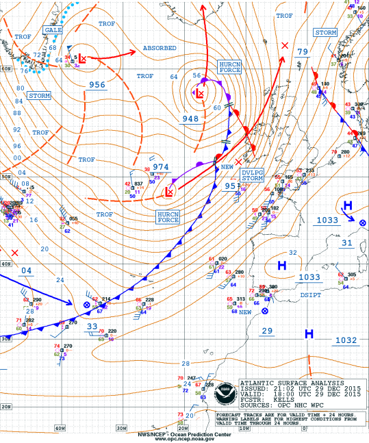
(Three
of Frank’s multiple strong low pressure systems raging through the
North Atlantic on Tuesday, December 29. At 956, 948, and 974 mb, two
of these lows each pack the strength of a major hurricane — but
with their energy spread out over a larger area. By late tonight two
of these lows will have combined and tracked toward Iceland bombing
out into a 920 mb class monster storm. Meanwhile, the far flung
effects of these storms will have resulted in yet another round of
high winds and very severe flooding for England. Image source: Ocean
Prediction Center.)
It’s
a storm with impacts stretching from just west of Spain and all the
way to the North Pole itself. A sprawling monster of a thing covering
the area the size of a small continent. The very precursor in fact of
Dr. James Hansen’s ‘continent-sized frontal storms packing the
strength of hurricanes.’ The dark beasts this visionary scientist
feared might arise during an age in which the great glaciers of the
world started to melt — the cool outflow of their waters
conflicting with a raging human forced warming of the globe to
radically destabilize the world’s weather (see Storms
of My Grandchildren).
The
impacts of this storm, which the UK Met Office is now calling Frank,
could well be tremendous. Cumbria in Northern England may be set to
experience yet another ‘worst flood on record’ — one of three
occurring just this month. And the 920 mb range central low of this
sprawling system is forecast to rip through the heart of Iceland
itself. But the more visible risk of damages to England and Iceland
may well pale in comparison to the quiet, yet drastic impacts taking
place in the far north.

(Unprecedented
doesn’t even begin to describe rain over Arctic sea ice above the
80 degree North Latitude line on the evening of Tuesday, December 29,
2015. It’s something we’d rarely see during summer time. But this
rain is falling through the black of polar night during the coldest
time of the year. Image source: Climate
Reanalyzer.)
There,
over the Arctic sea ice today, the rains began in winter time.
As
the first front of warm air proceeded over the ice pack to the north
of Svalbard, the rains fell through 35-40 degree (F) air
temperatures. It splattered upon Arctic Ocean ice that rarely even
sees rain during summer-time. Its soft pitter-patter a whisper that
may well be the sound to mark the end of a geological age.
For
we just don’t see rain over Arctic sea ice north of Greenland
during Winter time. Or we used to not. But the warmth that liquid
water falling through the black of what should be a bone-cold polar
night represents something ominous. Something ushered to our world by
human fossil fuel industry’s tremendous emission of heat trapping
gasses. Gasses that in the range of 400 ppm CO2 and 485 ppm CO2e are
now strong enough to begin to roll back the grip of Winter. Gasses,
that if they keep being burned until we hit a range between 550-650
ppm CO2 (or equivalent) will likely be powerful enough to wipe out
Winter as we know it entirely over the course of long and tumultuous
years of painful transition.
What
does the beginning of the end of Winter sound like? It’s the soft
splash of rain over Arctic Ocean sea ice during what should be its
coldest season.
Links:
Hat
Tip to DT Lange
Hat
Tip to Spike
Hat
Tip to Ryan in New England
The Storm That Will Unfreeze the North Pole
It
caps off a month—and year—of weird weather.
ROBINSON
MEYER

29
December, 2015
The
sun has not risen above the North Pole since mid-September. The sea
ice—flat, landlike, windswept, and stretching as far as the eye can
see—has been bathed in darkness for months.
But
later this week, something extraordinary will happen: Air
temperatures at the Earth’s most northernly region, in the middle
of winter, will rise above freezing for only the second time on
record.
On
Wednesday, the same storm system that last week spun up deadly
tornadoes in the American southeast will burst into the far north,
centering over Iceland. It will bring strong winds and pressure as
low as is typically seen during hurricanes.
That
low pressure will suck air out of the planet’s middle latitudes and
send it rushing to the Arctic. And so on Wednesday, the North Pole
will likely see temperatures of about 35 degrees Fahrenheit, or 2
degrees Celsius. That’s 50 degrees hotter than average: It’s
usually 20 degrees Fahrenheit below zero there at this time of year.
Winter
temperatures have only snuck above freezing at the North Pole once
before. Eric Holthaus, Slate’s
meterologist, could not
find an Arctic expert who
had witnessed above-freezing temperatures at the pole between
December and early April.
2015
is the
warmest year ever recorded. Thirteen
of the top 14 warmest years on the books have
happened this century. And here in the United States, it has been a
hot, strange month. Many cities across the northeast smashed their
Christmas and Christmas Eve temperature records not at midday, but at
the stroke of midnight. For the hundred-plus years that New York
temperatures have been recorded, the city has never been warmer than
63 degrees Fahrenheit on a December 24. Yet at 1 a.m. on Christmas
Eve of this year, the thermometermeasured
67 degrees.
Some
of this North American heat is a regular feature of every El Niño.
(Indeed, I wrote about this
El Niño-associated heat a few weeks ago.)
But in the Arctic, this level of warmth is unprecedented. In order
for this huge, hot storm to reach Iceland on Wednesday, it’s
punching right through the Jet Stream, the atmospheric “river”
that brings temperate weather to Europe. Yet El Niño should
typically reinforce this current, explains the
climate writer Robert Scribbler—for
the Jet Stream toweaken is
a sign that something else is going on.
While
institutional science will take years, if not decades, to confirm a
correlation between human-forced climate change and strong North
Atlantic storms, Scribbler believes that Wednesday’s insane warmth
at the pole resembles the southern incursions of the “polar vortex”
that have been seen in recent winters. These changes are related to
human-forced climate change, he writes: a sign that something in the
atmosphere has gone “dreadfully wrong.”
No comments:
Post a Comment
Note: only a member of this blog may post a comment.