

Potential
For El Nino Spikes As Record Pacific Ocean Heat Content Continues
to Emerge

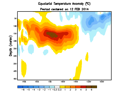
Extraordinary temperature departures in the range of 4-6 C above average stretched from a zone from 180 West Longitude to 80 West Longitude and ranged in depth from 30 to 70 meters. This very large zone of above average heat shattered global records even as it slid into position to begin re-delivering that excess to the atmosphere.


Dipole. It’s a word often used among meteorologists and climate scientists. But what does it mean?
But to understand how an excessively extreme dipole relates to the historic events of the winter of 2013-2014, it helps to open up one’s imagination. It helps to describe the ground-breaking information provided by Dr. Wang’s new paper in descriptive terms. It helps to, at first, envision a wave. Then to imagine the up-slope of the wave forming a hot, red shape. Now imagine the down-slope forming a cold, blue shape. Now think of this wave growing more intense, extending further in both its up-slope and in its down-slope. Growing hotter on the up-slope side and comparatively colder on the down-slope side.


17
April, 2014
(Very
powerful Kelvin Wave still moving eastward even as it begins to sink
in off the coast of South America. Image source: NOAA.)
Likelihood
for a significant El Nino later this year continued to increase as
the most powerful Kelvin Wave on record continued its progress into
the Eastern Equatorial Pacific. According NOAA’s recent April 13
assessment, the massive slug of anomalously hot Pacific subsurface
waters continued to surge eastward, to deepen the 20 C isotherm and
to spread out on or just below the surface.
NOAA’s
most recent CPC report finds, in a bald refutation to assertions by
climate change deniers, that:
A significant downwelling oceanic Kelvin wave that was initiated in January greatly increased the oceanic heat content to the largest March value in the historical record back to 1979 and produced large positive subsurface temperature anomalies across the central and eastern Pacific.
Extraordinary temperature departures in the range of 4-6 C above average stretched from a zone from 180 West Longitude to 80 West Longitude and ranged in depth from 30 to 70 meters. This very large zone of above average heat shattered global records even as it slid into position to begin re-delivering that excess to the atmosphere.
Perhaps
more importantly, the nose of this wave of far warmer than normal
water had begun to sag, pushing the 20 C isotherm deeper into the
Eastern Pacific even as cooler water from the depths began to punch
into the tail of the record hot Kelvin Wave, raising the 20 C
isotherm in the Western Pacific. This downwelling force of a monster
Kelvin wave appears to just now be initiating the start to a global
weather-altering El Nino.
Hot
Water Downwelling, Weakening Trade Winds
In
the East, from 12 February to 13 April, the 20 C isotherm had plunged
from about 25 meters below to around 100 meters of depth. During the
same period, the isotherm from about 150 East Longitude to 170 West
had risen from about 210 meters to 170 meters. At the subsurface, a
continued rising of the isotherm in the West and its continued fall
in the East would complete the transfer of warm waters across the
Pacific and open the flood gates to the start of what could be an
extraordinarily strong El Nino event as what is now a record Pacific
Ocean heat content starts bleeding back to the atmosphere.
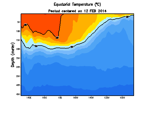
(20
C isotherm continues to rise in the Western Pacific [left side of
graph] even as it rises in the East [right side]. Image
source: NOAA.)
On
the surface, trade wind weakening and reversals continued with a
significant, though milder than those seen in January and February,
backflow emerging in early April east of the Solomon Islands and
coinciding with rather weak trade winds across the Equatorial
Pacific. Such conditions continued to provide surface impetus to
transfer warm waters across the Pacific even as record
subsurface heat continued its transition eastward.
Chances
for El Nino Rise
Accordingly,
predictive forecasts both by NOAA and Australia’s Bureau of
Meteorology are showing increasing potentials that El Nino will
emerge. NOAA’s forecast now indicates that the chance for El Nino
has jumped to over 50% by this summer and to 66% by the end of the
year. Australia’s forecast is now showing a greater than 70% chance
of El Nino over the same period.
In
addition, El Nino type influences are already beginning to appear in
world weather systems. A
recent report by Dr. Simon Wang found that precursor El Nino
conditions combined with effects related to climate change such as
Arctic sea ice loss to spur and enhance epic drought conditions in
California.
Southeast Asia is already experiencing heat and dryness that is
typically associated with a developing El Nino. Northern Brazil is
also seeing increasing levels of heat and drought. To the
North, Siberia
is experiencing an extraordinary April onset to fire season while
the northeastern US is somewhat cooler than average due to the
persistent and anomalous strength of a dipole of warm temperature
extremes in western North America and cool temperature extremes in
eastern North America.
Many
of these impacts, though expected in a normal El Nino year appear to
be enhanced by effects related to human caused climate change such as
sea ice loss and an amplification of the hydrological cycle
increasing the frequency of extreme rainfall, drought and fire events
(as in the California drought and the southeast Asian and Siberian
fires).
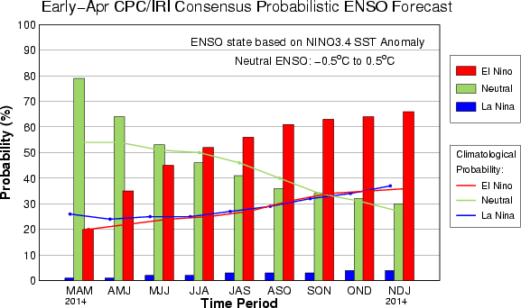
(El
Nino model runs by NOAA’s Climate Prediction Center show 66%
potential for El Nino Development by November, December and January
of 2014-2015. Image source:CPC/IRI.)
During
a typical strong El Nino year, global weather disruptions can cause
severe damage resulting in reductions to world GDP by as much as 5%.
But with the added and enhanced severe weather effects due to climate
change interacting with El Nino, overall impacts could be far more
destructive. In addition, a release of what is currently record
Pacific Ocean heat content into the atmosphere will likely set off
new high temperature extremes, further pushing the global climate
system toward the very dangerous 2 C warming threshold.
Links:
Winter of 2013-2014 Sees
Most Extreme Dipole on
Record
How a Strong Emerging El Nino Conspired With Climate Change to Ignite Record Drought in California and Collapse the Polar Vortex
17 April, 2014
Dipole. It’s a word often used among meteorologists and climate scientists. But what does it mean?
In
weather terms we can simply think of it as this: one side hot, one
side cold. So, as a basic principle, it’s pretty direct. But in a
world where extremes between hot and cold are becoming more intense,
in North America which has just experienced its most extreme dipole
anomaly since record keeping began in 1960, it’s also something
that’s important to understand as it relates to ongoing
human-caused climate change.
For a
recent blockbuster scientific paper by Dr. Simon Wang and associates
and published in Geophysical Research Letters has
now linked this extreme temperature differential, related polar
vortex collapse events, and the California drought with both ongoing
physical changes to the Earth System due to human caused climate
change and to the
first rumblings of a monster El Nino in the Pacific.
Envisioning
a Dipole Pushed into An Extreme Form by Climate Change
But to understand how an excessively extreme dipole relates to the historic events of the winter of 2013-2014, it helps to open up one’s imagination. It helps to describe the ground-breaking information provided by Dr. Wang’s new paper in descriptive terms. It helps to, at first, envision a wave. Then to imagine the up-slope of the wave forming a hot, red shape. Now imagine the down-slope forming a cold, blue shape. Now think of this wave growing more intense, extending further in both its up-slope and in its down-slope. Growing hotter on the up-slope side and comparatively colder on the down-slope side.
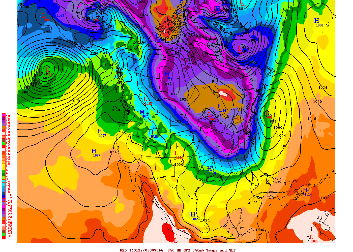
(GFS
Model summary of Polar Vortex Collapse event on January 19, 2014
shows 850 mb temperatures over the Eastern US colder than the same
temperatures over parts of Greenland and the Arctic Ocean. 850 mb
temperatures over St. Augustine, FL are the same as 850 mb
temperatures over central Greenland. Anomalies on the hot side of the
dipole in the Arctic hit +40 degrees Fahrenheit in some places.
Anomalies on the cold side of the dipole hit more than -35 degrees F
in some places. Note the twin, dense high pressure systems sitting
sentinel just off the California Coast and deflecting storms north
into Alaska. Image source: NOAA/GFS.)
Having
established the wave form and related temperature extremes, lay the
shape over North America and adjacent Pacific Ocean. The up-slope
covers the Eastern Pacific, Alaska, a section of the Beaufort Sea in
the Arctic, Western Canada and the Western US. The down-slope swings
from the eastern side of the Beaufort, on in through Central and
Eastern Canada and bisects the US diagonally from the Dakotas to the
Gulf Coast east of Texas.
Now
let’s envision this wave as a flow of upper level air called the
Jet Stream and let’s think about the various atmospheric aspects
that feed it. Looking west, we happen upon a very warm pool of water
in the Western Pacific east of the Philippines. This warm pool is the
source of an El Nino that will likely occur within one years time. A
heat pocket given added intensity by both rising atmospheric
temperatures and strong winds transferring that added energy into the
vast Pacific Ocean. The heat waits, wanting to spread out across the
Pacific surface in an energetic return to the air. But, for now, it
simmers in its deep pool, providing energy for the powerful dipole
we’ve just described.
The
heat from this warm pool radiates into the atmosphere creating lift.
Further north, a cold pocket is driven south by another strong
atmospheric wave pattern over the Asian continent. The cold air
pocket runs south over Japan. The hot and the cold difference
generates a very strong upper level synoptic (horizontal form weather
patterns stretching more than 1,000 kilometers) wind pattern that
stretches all the way across the Pacific Ocean.
The
winds run southwest to northeast until they encounter the hot bulge
of our already described dipole over the Eastern Pacific near the US
west coast and Canada. This warm current turned the already rapid
winds due north where they rushed up over Alaska and into a sea ice
pack far weaker than in decades past. A sea ice sheet gradually
thinning, breaking up, and venting heat from a warming Arctic Ocean
below. And so these, already strong, winds were not turned back by
the now much weaker cold until they had driven far, far into the
Arctic Ocean (and it
is here that we must give a hat tip to Dr. Jennifer Francis, who
finds her predictions regarding sea ice loss and high amplitude Jet
Stream waves again validated).
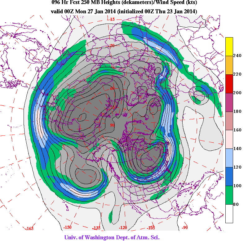
(Upper
level wind pattern on January 23, 2014 shows a polar vortex that has
essentially been ripped in half by the warm side of the west coast
dipole and the high amplitude Jet Stream wave forming over top of it.
Image source: University
of Washington.)
Now
imagine a strong dome of high pressure forming in the wake of this
powerful and ongoing wind flow, sheltered and growing ever stronger
on the hot side of the dipole. Imagine it blocking the path of
storms, even as it concentrated heat and warmth. Imagine California
receiving 1/4 or less of its typical winter rainfall as a result. A
most recent and extreme insult to years of drought forcing
authorities to ration water in many places.
Now
return to that strong wind finally being turned south somewhere in
the far, far north, in the Beaufort Sea just south of the North Pole.
Then imagine these now cold-laden winds rushing south. Running over
Hudson Bay and eastern Canada. Roaring over the Great Lakes and
carrying with them a cyclone of cold Arctic air that should have
remained in the far north. The polar vortex that should have stayed
over places like Svalbard but instead collapsed under the warm wind
flow and shifted far south to places like Toronto or Chicago or
Detroit or Washington DC.
Now
at last imagine another synoptic pattern as the Arctic air of the
polar vortex encounters the warmth of the Gulf Stream. This pattern
is laden with powerful storms that bomb out over the UK again and
again, resulting in the stormiest winter for that island nation in
over 200 years.
And
here we have the dipole of the winter of 2013 and 2014. A west coast
that was hot, hotter than usual all the way from California to the
far north of Alaska and an East Coast that from Canada to the Gulf
Coast became the repository for cold, cold Arctic air that was shoved
south as the polar vortex collapsed down the steep face of the one of
the largest and longest lasting Jet Stream waves on record.
(Dr.
Francis explains how polar amplification results in higher amplitude
Jet Stream wave patterns.)
Dipole.
One side hot. One side cold. But, in this case, in the case of the
winter of 2013-2014, it’s a historic and anomalous dipole. A freak
born of the climate change we’ve caused mixing up with the Pacific
Ocean heat of a rising El Nino. A record hot, dry winter for the US
West that ignites wildfires in winter and forces the government to
ration California water resources. A severe dry spell that closes
farms and drives US food prices up by 15%. A record cold, stormy
winter in the Eastern US and a series of super-intense storms
screaming across the North Atlantic to submerge Somerset and rip
massive chunks out of a rocky UK coastline.
This
clear picture of a climate-change caused event was this week
provided through
the groundbreaking new research by Dr. Wang and fellows.
These top scientists engaged climate models and analyzed past records
to find the culprits of the weather extremes we witnessed during this
past winter. And what they found was a very high correlation in the
models with the extreme dipole over North America and the Arctic, an
oncoming El Nino, and climate change driven impacts.
For
not only was this year’s dipole the most extreme on record, it was
also likely made far more extreme by an emerging Monster El Nino
acting in concert with severe global-warming related reductions in
Arctic sea ice cover, increases in Pacific Ocean heat and atmospheric
moisture content, and related changes to the upper level air flows of
the Northern Hemisphere polar Jet Stream.
Links:
Read
Further Excellent Reporting on the Wang Report Here:
Large
and Growing List of Scientific Studies Linking Human Climate Change
to Current Weather Extremes (hat
tip to Weather Underground)
No comments:
Post a Comment
Note: only a member of this blog may post a comment.