Introduction
to
“homogenitus” cloud
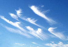
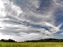
A wee way back I posted an article with these strange cloud formations and explained that although I have seen these clouds on a regular basis in the last year whereas previously I had never seen them before at any stage of my 63 years on the planet.
A reader came back immediately and helpfully pointed me towards pictures of what I learned are called scalar wave clouds.
I decided to look back to previous years and see what Collier's Encyclopedia (ca. 1980) said about cloud formations.
On searching I found a video made by an Andy Leifer who leafs back over old books on clouds and finds examples from the 1920's and 1930's of altostratus clouds which Colliers says "rain or snow will follow within 15 or 20 hours"
The thing is that these clouds have NEVER ONCE produced rain or snow when I have seen them.
The following is what Wikipedia says about all of this:
Here is an example relating to different types of cirrus cloud:
High-level cirriform, stratocumuliform, and stratiform[edit]
High clouds form in the highest and coldest region of the troposphere from about 5 to 12 km (16,500 to 40,000 ft) in temperate latitudes.[4][5] At this altitude water almost always freezes so high clouds are generally composed of ice crystals or supercooled water droplets.
Genus cirrus[edit]
Abbreviation: Ci
There are several variations of clouds of the cirrus genus based on species and varieties:
Species[edit]
- Cirrus fibratus (V-1)
High clouds having the traditional "mare's tail" appearance. These clouds are long, fibrous, and curved, with no tufts or curls at the ends. - Cirrus uncinus (V-2)
Filaments with up-turned hooks or curls. - Cirrus spissatus (V-3)
Dense and opaque or mostly opaque patches. - Cirrus castellanus (V-4)
A series of dense lumps, or "towers", connected by a thinner base. - Cirrus floccus (V-5)
Elements which take on a rounded appearance on the top, with the lower part appearing ragged.[6]
-
- Opacity-based varieties
- None; always translucent except species spissatus which is inherently opaque.[7]
-
- Fibratus pattern-based varieties
- Cirrus fibratus intortus (V-6)
Irregularly curved or tangled filaments. - Cirrus fibratus vertebratus (V-7)
Elements arranged in the manner of a vertebrate or fish skeleton.
- Cirrus fibratus intortus (V-6)
-
- Pattern-based variety radiatusLarge horizontal bands that appear to converge at the horizon; normally associated with fibratus and uncinus species.
- Cirrus fibratus radiatus (V-8)
- Cirrus uncinus radiatus (V-9)
-
- Pattern-based variety duplicatusSheets at different layers of the upper troposphere, which may be connected at one or more points; normally associated with fibratus and uncinus species.
- Cirrus fibratus duplicatus (V-10)
- Cirrus uncinus duplicatus (V-11)
-
- Varieties are not commonly associated with Ci species spissatus, castellanus, or floccus.[6][7]
-
-
-
- Precipitation-based supplementary features
- Not associated with cirrus.
-
-
-
-
-
- Cloud-based supplementary feature
- Mamma
Bubble-like downward protuberances; mostly seen with species castellanus.[8]
- Mamma
-
-
-
-
-
- Genitus mother clouds
- Cirrus cirrocumulogenitus
- Cirrus altocumulogenitus
- Cirrus cumulonimbogenitus
- Cirrus homogenitus. Cirrus formed by spreading of aircraft contrails.
-
-
-
-
-
- Mutatus mother cloud
- Cirrus cirrostratomutatus
-
-
This was interesting. They have come up with a new category of clouds that was definitely not in Colliers or any former book on clouds - homeogenitus clouds
"Contrails formed from the exhaust of aircraft flying in the upper level of the troposphere can persist and spread into formations resembling any of the high cloud genus-types and are now officially designated as cirrus, cirrostratus, or cirrocumulus homogenitus. If a homogenitus cloud of one genus changes to another genus type, it is then termed a homomutatus cloud. Stratus cataractagenitus (Latin for 'cataract-made') are generated by the spray from waterfalls. Silvagenitus (Latin for 'forest-made') is a stratus cloud that forms as water vapor is added to the air above a forest canopy.[83]"
Now, the interesting thing about the Wikipedia articles (there are at least two) on clouds is that they have the following examples of clouds that would certainly never have featured in previous books on clouds (because they never existed).
They are precisely those clouds that people have been posting on the internet to indicate geoengineering, 'chemtrails' and so forth.
It seems to me an attempt to paint as "normal" what is not normal at all.
Sceptics tend to point to articles like this and say "look, here you are. It's all normal and scientific".
What we are seeing however, is nothing more or less than a classification of clouds using traditional criteria.
Just classifying something and giving it a Latin name gives it a scientific aura and says nothing about the origin of the clouds.
Here are some examples of what I am talking about.
With those Latin names it has to be real, right?
With those Latin names it has to be real, right?
Just because something as weird as the above is given a name like cirrus fibratus radiatus does it mean that it has a natural origin?
Of course it doesn't!
Here are some cloud formations that have been described as scalar energy clouds.
I haven't seen any examples of these with a Latin name!
Talking of "cirrus homegenitus" here is an article someone wrote about this.
Cirrus Homogenitus
Cloud
of the Day – Cirrus Homogenitus
In the past, meteorologists refused to include human-made phenomena in their classifications of cloud types. Yes, they said, the steam and smoke coming out of our smokestacks can appear like clouds or fog, but they’re not really. While weather observers might observe reduced visibility and even attribute it in part to our activities, there was no place for them on the reporting forms. If they were going to mention smog or condensation trails, it would be in the comments only. In the case of condensation trails, they became abbreviated in common language as “contrails.” On the reporting forms they appeared in the comments section as “COTRA.”
In the past, meteorologists refused to include human-made phenomena in their classifications of cloud types. Yes, they said, the steam and smoke coming out of our smokestacks can appear like clouds or fog, but they’re not really. While weather observers might observe reduced visibility and even attribute it in part to our activities, there was no place for them on the reporting forms. If they were going to mention smog or condensation trails, it would be in the comments only. In the case of condensation trails, they became abbreviated in common language as “contrails.” On the reporting forms they appeared in the comments section as “COTRA.”
Now, with the updating this year of the International Cloud Atlas, hosted by the World Meteorological Organization, as reported on the Green Comet blog, a number of new cloud types have been included. I’ve already reported on asperitas, volutus and flumen, which are natural cloud types that have been included in this edition of the Atlas. Today I present another inclusion, this time a cloud type that results from human activity: cirrus homogenitus. Literally, cirrus made by humans. Condensation trails can now come out of the comments and take their rightful place in the form proper.
Cirrus homogenitus is the new name for contrails that have persisted for at least ten minutes. It comes in the one type only, with no sub-types or varieties. That’s because contrails are usually quite ephemeral and either disappear or change rapidly.
Cirrus homogenitus are like other cirrus clouds in that they don’t result in any precipitation or other weather. Unlike cirrus, they can’t even be credited with foretelling the approach of a weather system. They’re just the result of an airplane flying in the stratosphere, portending nothing more than its arrival, hopefully at its destination.
And another article -
| Weather Engineering Signatures in Cloud Formations
GIANT RADIALS
|
Giant radial cloud formation over the Santa Barbara, Ca, USA coastline. November 1, 2016
—Photo © Anthony Craddock
Canon EOS 5D Mk IV
f/8, 1/320, ISO-100, 16mm
What
does this indicate?
|
||||||||||||
First of all, it is not a natural cloud pattern.
Here
is the official 1928 U.S. Government Department
of Agriculture Weather Bureau catalog of Cloud Forms,
compiled by the Weather Bureau Cloud Committee.
This
was authored at a time when the clouds were not being
artificially manipulated by unseen electromagnetic forces, so is
a great reference for how true natural cloud forms should
look.
(As are many of the skies filmed in old movies!)
Many
of us are too young to have ever seen true natural clouds in the
sky
Click
to Download this free reference booklet
(thanks so much to our brilliant research assistant for finding this booklet) |
||||||||||||
So
what is going on here?
|
||||||||||||
Tom
Bearden's diagrams in his “Fer
de Lance” and “Star
Wars Now!” books
shows us exactly how this cloud formation indicates the steering
of the jetstream across the U.S.A by creating low and high
pressure spots.
VIRTUAL TRANSMITTERS EMBEDDED IN THE INTERFERENCE GRID
FORMATION OF A DOUBLE GIANT RADIAL |
||||||||||||
A
comprehensive explanation of how exactly all this scalar EM
weather engineering is carried out, as well as its history of
development, can be seen in Tom Bearden's classic DVD “Soviet
Weather Engineering over North America.”
Moving
the jet stream around to engineer the weather can, for example,
entrain moisture from over the Pacific Ocean, and mix it with
cold air displaced from Canada to create snow and icy
conditions. If curls are added, tornadoes will result, and
so on.
Note:
the radial clouds are now deliberately “roughed up” to
try to make the pattern less obvious to casual observers. They
are usually stable in a wind blown sky, and will disappear almost
immediately when the generating power is cut off.
| ||||||||||||


No comments:
Post a Comment
Note: only a member of this blog may post a comment.