

'Unprecedented':
more than
100 Arctic wildfires burn in
worst ever season
Huge
blazes in Greenland, Siberia and Alaska are producing plumes of smoke
that can be seen from space
26
July, 2019
The
Arctic is suffering its worst wildfire season on record, with huge
blazes in Greenland, Siberia and Alaska producing plumes of smoke
that can be seen
from space.
The
Arctic region has recorded its hottest
June ever.
Since the start of that month, more than 100 wildfires have burned in
the Arctic circle. In Russia, 11
of 49 regions are
experiencing wildfires.
The
World Meteorological Organization (WMO),
the United Nations’ weather and climate monitoring service, has
called the Arctic fires “unprecedented”.
The
largest blazes, believed to have been caused by lightning, are
located in Irkutsk, Krasnoyarsk and Buryatia. Winds carrying smoke
have caused air quality to plummet in Novosibirsk, the largest city
in Siberia.
In
Greenland, the multi-day Sisimiut
blaze, first detected on 10 July, came during an unusually warm and
dry stretch in which melting on the vast Greenland ice sheet
commenced a month earlier than usual.
In
Alaska, as many as 400 fires have been reported. The climatologist
Rick Thomas estimated the
total area burned in the state this season as of Wednesday morning at
2.06m acres.
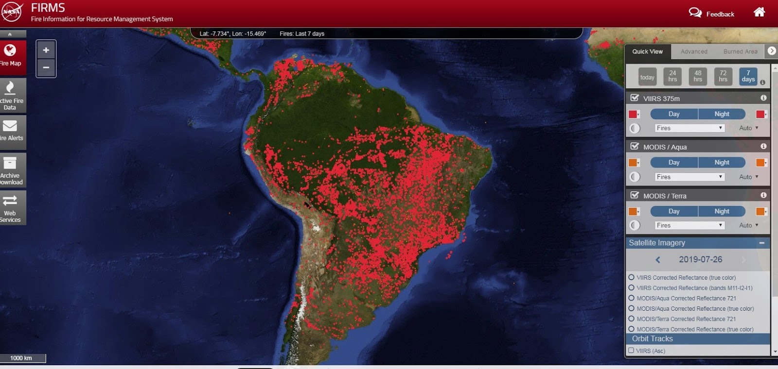
Mark
Parrington, senior scientist with the Climate Change Service and
Atmosphere Monitoring Service for Europe’s Copernicus
Earth ObservationProgramme, described
the extent of
the smoke as “impressive” and posted an image of a ring
of fire and smoke across
much of the region.
Thomas
Smith, an environmental geographer at the London School of
Economics, told USA
Today fires of such magnitude have not been seen in the 16-year
satellite record.
Arctic wildfires emitted as much CO2 in June as Sweden does in a year
The
fires are not merely the result of surface ignition of dry
vegetation: in some cases the underlying peat has caught fire. Such
fires can last for days or months and produce significant amounts of
greenhouse gases.
“These
are some of the biggest fires on the planet, with a few appearing to
be larger than 100,000 hectares,” Smith said.
“The
amount of [carbon dioxide] emitted from Arctic circle fires in June
2019 is larger than all of the CO2 released from Arctic circle
fires in the same month from 2010 through to 2018 put together.”
In
June alone, the WMO said, Arctic fires emitted 50 megatonnes of CO2,
equal to Sweden’s total annual emissions.
Plus this
And this..

Fires
are commonplace in Africa at this time of year. Even the
thousands of them as seen in this NOAA/NASA Suomi NPP satellite
image. Why? The most likely explanation is the type of
agricultural practice that is employed in this area of the world.
Called "slash and burn" this type of field clearing is both
inexpensive and low tech. It also works. The resulting
layer of ash generated by the slash and burn practice provides the
newly-cleared land with a nutrient-rich layer to help fertilize
crops. That is not to say that every fire in this image is
controlled or contained. Often fires set to renew fields can
grow out of control as winds or storms move the fire out of the area
that was to be cleared. What is definite is that these fires
have been burning for at least a month. Looking backward in
NASA's Worldwide satellite imagery application, the basic number
of fires appears constant for the past 30 days. Which brings up
another point. While fire helps enhance crops and grasses
for pasture, the fires also produce smoke that degrades air
quality. The European Space Agency (ESA) published an
article on February 04, 2019 about fires in
Africa. The article mentioned, "It is currently
estimated that fires contribute 25–35% of total annual greenhouse
gas emissions to the atmosphere so more precise information gained
from satellite-based scar-burn maps could help to better understand
how they add to the greenhouse effect. The authors (of the study
cited in this article) focused on sub-Saharan Africa as the region
accounts for around 70% of burned area worldwide according to global
satellite databases, making it the ideal testbed for evaluating the
potential for improving the understanding of global impacts of fire."
NOAA/NASA's
Suomi NPP satellite collected this natural-color image using the
VIIRS (Visible Infrared Imaging Radiometer Suite) instrument on June
10, 2019. NASA's Earth Observing System Data and Information
System (EOSDIS) Worldview application provides the capability to
interactively browse over 700 global, full-resolution satellite
imagery layers and then download the underlying data. Many of the
available imagery layers are updated within three hours of
observation, essentially showing the entire Earth as it looks "right
now." Actively burning fires, detected by thermal bands, are
shown as red points. Image Courtesy: NASA Worldview, Earth Observing
System Data and Information System (EOSDIS). Caption: Lynn Jenner
with information from the ESA
Sentinel-2 website.
Last
Updated: June 12, 2019
Editor: Lynn
Jenner

No comments:
Post a Comment
Note: only a member of this blog may post a comment.