

Hurricane Michael Downgraded To Cat 3 As Eye Approaches Alabama, Georgia
10
October 2018
Update
(5:15 pm ET): After
picking up steam immediately ahead of landfall, Michael has been
downgraded to a Category 3 storm, and its eye is now approaching
southeastern Alabama and southwestern Georgia. The storm is moving at
a brisk 16 mph with a max windspeed of 125 mph.
The
NHC is giving a live update on the storm at 5:35 pm ET:

NHC Director Ken Graham will provide a Facebook Live broadcast regarding the latest on Hurricane #Michael at 5:35 p.m. EDT (4:35 p.m. CDT) facebook.com/NWSNHC @NOAA @NWS @NWSWPC #HurricanePrep
Extreme
wind warnings are in effect for parts of Alabama, Georgia and
Florida..
.


Even though #Michael is moving farther inland, it remains an extremely dangerous hurricane with many different hazards. Here are the Key Messages for Oct 10 at 5 pm EDT (4 pm CDT). The full advisory is at: hurricanes.gov
...As
the NHC warns that the storm will continue to produce "life
threatening" winds...

#Michael will continue to produce life-threatening hurricane-force
winds well inland across portions of the Florida Panhandle,
southeast Alabama, and southwestern Georgia this evening as the core
of the hurricane continues to move inland. hurricanes.gov
...As
well as life threatening flash flooding
.


Heavy rainfall from #Michael could produce life-threatening flash
flooding from the Florida Panhandle & Big Bend regions into
portions of southeast Alabama, Georgia, the Carolinas, and southeast
Virginia. See the latest @NWSWPC forecasts for more details: wpc.ncep.noaa.gov
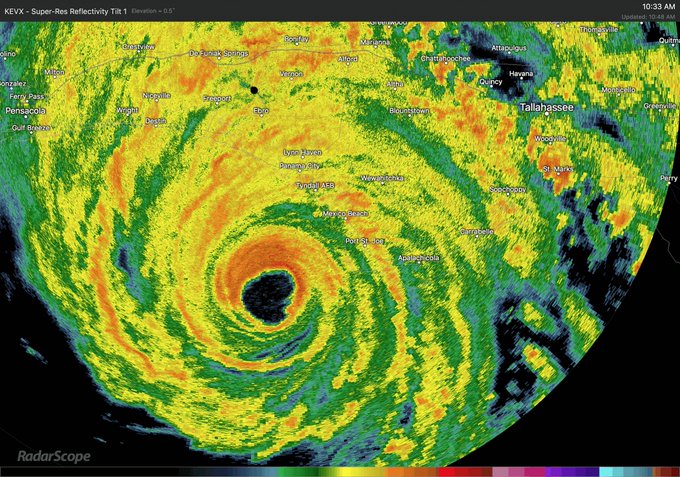
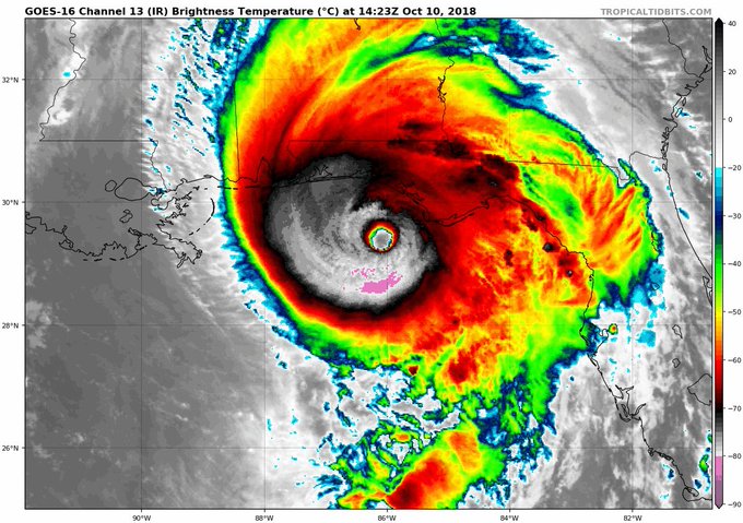
Here's
a satellite view of the storm as it moves inland.
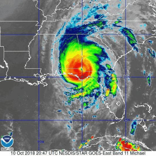
Satellite loop of #HurricaneMichael. Newest advisory at 5pm, hurricane still a Category 3 with max sustained winds of 125mph. Eye at intersection of SW GA, SE AL, and FL.
Meanwhile,
videos of the devastation caused by Michael's deadly storm surge are
beginning to circulate on Twitter. The following video was taken on
Cook St. on St. George Island, a town in located in Franklin County,
and shows a home completely submerged as the town appears to have
sunken into the sea.
* *
*
Update
(3:30 pm ET): Michael's
winds have slowed only slightly (max windspeeds have fallen to about
140 mph) as the eye of the storm has moved decisively ashore, and
eyewall - the most dangerous part of the storm - has moved on from
Bay County to Jackson County as the storm moves inland and approaches
I-10.

Here is the 3 PM CDT position update for #Michael: Eye of #Michael approaching I-10 in the Florida Panhandle nhc.noaa.gov/text/refresh/M…
Water
levels in Apalachicola Florida have climbed to 7.72 feet above high
tide, breaking a record set by Hurricane Dennis in 2005.

Water levels at NOAA’s tide gauge in Apalachicola, Florida, have reached 7.72 ft above high tide from #Michael. This breaks the record set in 2005 from Hurricane Dennis. Get info here: tidesandcurrents.noaa.gov/inundationdb/i…
With
details on casualties still fuzzy (the Guardian reported that a woman
in Franklin County was hit in the head by a falling tree limb, but
first responders were unable to reach her), the devastation wrought
by the hurricane extended all the way to Lower Manhattan...
FEMA
gave a joint briefing with President Trump shortly before Michael
made landfall on Wednesday. And now the Department of Defense is
giving a briefing of its own.
The @DeptofDefense holds a briefing on Hurricane Michael preparations. fxn.ws/2QGxa6q twitter.com/i/broadcasts/1…

* * *
Update
(1:40 pm ET): The
"worst case scenario" has become a reality. Hurricane
Michael made landfall near Mexico Beach, Florida at 1:40 pm as a
Category 4 hurricane with sustained winds of 155 miles per hour
(that's 2 mph shy of Category 5 status). Already, the storm is the
most powerful hurricane to make landfall in the Continental US in 14
years.
Florida
Gov. Rick Scott declared that "Hurricane Michael is upon us".
And as the
New York Times added, for
those who lingered a little too long, the time to evacuate has now
passed. Instead,
everybody remaining in the evacuation zones is being advised to
hunker down and say a few prayers. The mandatory evacuation zone in
Florida encompassed some 375,000 residents - but it's not clear how
many chose to leave. States of emergency have been declared in parts
of five states - Florida, Georgia, Alabama, North Carolina and South
Carolina - affecting some 12 million people. Compared with Florence,
Michael is moving at a relatively swift 15 mph, and is already
beginning to hammer parts of southern Georgia. Roughly 4,000 people
slept in storm shelters last night, according to the Red Cross.
Already, 80,000 power customers have lost service, and floodwaters
have overtaken some homes in Mexico Beach, where the hurricane first
came ashore.

As the NYT pointed out, every update about the storm sounds more harrowing than the last:
Just about every update seemed to bring greater grimness: closed bridges, more towering waves, suspended emergency services, admonitions that the time to evacuate had passed. The hurricane center reported a 130-mile-per-hour wind gust near the evacuated Tyndall Air Force Base — and said that the measuring instrument had then failed.
Even
the journalists are too afraid to venture outside. One NYT reporter
tweeted the following photo showing himself and his fellow hotel
guests gathered in a windowless basement room as the hotel "shudders
like an LA Earthquake."

Those
brave enough to venture outside are depicting scenes of utter chaos
.
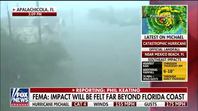
Phil Keating reporting from Apalachicola, FL: "There was a very large propane tank just floating all the down here and it's now parked under our garage." @ShepNewsTeam #HurricaneMichael fxn.ws/2QGxa6q
The
look of sheer terror on this poor dog's face says it all...

A man and his dog take shelter in a parking garage as Hurricane Michael passes through Panama City, Florida. fxn.ws/2QGxa6q
Watch
a live feed from Panama City below:
The
storm is the most powerful hurricane to ever hit the Florida
Panhandle. The catastrophic damage expected will likely knock out
power in Bay County and further inland to Tallahassee and southern
Georgia, Axios said.

Videos
of the eyewall smashing into Panama City Beach proliferated on social
media
.


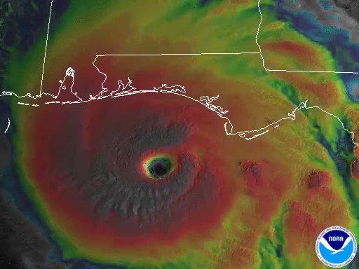
And
here's what Michael looks like from space:

Station cameras viewed Hurricane Michael at 12:58pm ET Oct. 10 after the storm made landfall as a category 4 storm over the Florida panhandle. The @NHC_Atlantic reported maximum sustained winds near 145 mph with the potential to bring dangerous storm surge and heavy rains.
Meteorologists
have been stunned by Michael's apparent determination to strike land
with as much force as possible. As recently as Monday, scientists
anticipated that the storm would hit the coast with Category 3 force
winds, or slower.

But
the fact that Michael is battering the Florida panhandle coastline
with 155 mph - just 2 mph shy of Category 5 - has left many
scientists slackjawed. As one meteorologist said on twitter, "never
in my worst nightmares did I think we would be dealing with a 155 mph
hurricane."
Here’s the landfall loop of #Michael for posterity- never in my worst nightmares did I think we would be dealing with a 155 mph #hurricane at landfall...

So
how did this happen? As Axios explains,
Michael faced a few obstacles when it first formed off the coast of
Cuba, including "wind shear", a wind pattern that helps
blunt the force of storm's winds. But the storm was able to overcome
them because it had the rest of the ingredients needed for rapid
intensification: Plenty of warm water, moist air, and an upper level
wind pattern over the northeast Gulf of Mexico that helped recycle
some of the wind pushed upward by the wind shear.
In
other words, it was "the perfect storm."
Some
storm chasers near Tyndall Air Force Base (which is situated squarely
in the path of the storm) managed to photograph the eye of the storm,
which offered a brief break of sunshine to some of the battered areas
below
:
Eyewall of Michael by Tyndall AFB. Full sunshine in eye! Experience of a lifetime. Now pray for the people affected. #flwx
* * *
Update
(1 pm ET): The
NHC has published the latest positioning update on Hurricane Michael.
The storm, now about 20 miles from the Florida coast, is expected to
make landfall between Panama City and St. Vincent.

Here is the 12 PM CDT position update for #Michael: Eyewall of Michael coming ashore along the coast of the Florida Panhandle between St. Vincent Island and Panama City. Do not venture out into the eye when it passes!
As
the eyewall of the storm approaches Panama City, one intrepid
reporter offered a glimpse into the mayhem
.
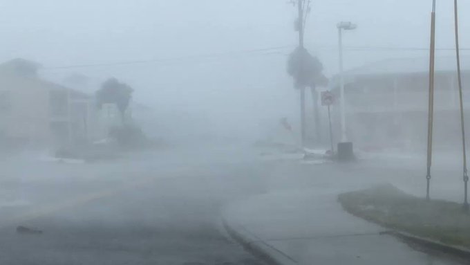
INTENSE eye wall east side of Panama City beach with Hurricane #Michael @accuweather @breakingweather

Catastrophic wind in eye wall of Hurricane #Michael in Panama City Beach eastern tip @breakingweather @accuweather
* * *
Update
(12 pm ET): Now
just 40 miles from Panama City, Hurricane Michael is still gaining
strength as it approaches the Florida panhandle. The storm has
apparently exceeded the expectations from the National Weather
Service, which warned that it is a "worst case scenario"
and will cause unprecedented devastation to the communities in its
path.
Landfall of #HurricaneMichael is imminent. THIS IS A WORST CASE SCENARIO for the Florida Panhandle!! Listen to your local emergency officials. Stay Inside & Survive!" --NWS Director Dr. Louis Uccellini @NWSDirector
Meanwhile,
the NWS' Tallahassee office said it issued its first ever "extreme
win warning" for parts of Bay County that will soon be
experiencing gusts of more than 130 mph.

The situation is about to get serious in parts of Bay, Gulf, and Franklin county. We've issued our first ever Extreme Wind Warning. This means wind gusts in excess of 130 MPH are expected as #HurricaneMichael makes landfall in the next few hours. Shelter in place IMMEDIATELY.
President
Trump tweeted satellite imagery showing just how powerful the storm
has become as it approaches the Florida coast, along with a message
of support.
Meanwhile,
scientists warned that Michael could strengthen into a Category 5
Hurricane before making landfall, as its maximum wind speeds of 150
mph were just 7 mph shy of the most dangerous category of
hurricane, per
USA Today.
"There doesn’t seem to be any opportunity for this storm to weaken at all, and it may strengthen," said Brett Rathbun, a meteorologist with AccuWeather.
One
thing's for sure: Michael
isn't slowing down.
Watch
a live feed of the storm's approach below:
Meanwhile,
President Trump is holding a live press briefing with FEMA:
* *
*
Update
(9 am ET): Hurricane
Michael continued to strengthen Wednesday morning, as the Category 4
storm's wind speed increased to 145 mph. The storm is now poised to
be the strongest to hit the US in 14 years, boasting a life
threatening storm surge and the potential to cause $16 billion in
damages.
The
storm is now roughly 90 miles southwest of Panama City and is heading
north at 13 miles per hour, according to the NHC's latest update. The
storm's outer bands are already battering the coastal town of
Apalachicola with winds of nearly 50 mph.

As
it stands, the storm is also poised to be the strongest to hit the
Florida panhandle and big bend since meteorologists first started
gathering data. Regional ports have closed in anticipation, and more
than 230 flights have been canceled. Duke Energy Corp., a utility
that supplies electricity to the region, expects more than 200,000
customers in the state will be without power. In preparation for the
widespread outages, local utilities have about 19,000 workers on
stand by ready to work to quickly restore power, with more workers
pouring in from out of state. Still, some areas are expected to be
without power for more than a week, per the
Daily Commercial.
"A storm like this could be a once-in-a-lifetime event," said Brett Rathbun, a meteorologist with AccuWeather Inc. in State College, Pennsylvania. "Winds of this intensity can really knock down any tree or structure in its path."
There
are also 3,500 National Guard members, 1,000 rescue workers and 3,000
FEMA employees in the area ready to aid in the response. Michael is
whipping up waves as high as 30 feet in the Gulf and could bring a
14-foot surge and 4 to 8 inches of rain, with some isolated areas
getting as much as 12 inches.

As
one meteorologist pointed out, the barometric pressure of the storm
system has continued to drop, and only four hurricanes have ever made
landfall in the Continental US with a lower pressure reading
.
#Hurricane #Michael's pressure continues to drop - now to 923 hPa. Only 4 hurricanes on record have hit the continental US with a lower pressure: Labor Day (1935), Camille (1969), Andrew (1992), Katrina (2005).
* * *
As
one meteorologist pointed out, if Michael doesn't weaken before
making landfall late Wednesday, it
would surpass Hurricane Eloise, which wrecked the panhandle in 1975,
and the Pensacola Hurricane of 1882 for strongest winds ever recorded
for a landfall in the panhandle.
If the storm's 140 mph+ wind speeds are maintained,
Michael could be the strongest storm to hit the area since the dawn
of record-keeping in 1851.
While
Florida residents are somewhat accustomed to record-breaking storms,
according to the Weather Channel, "no
long-time residents of this area will have seen a hurricane this
strong before." Stores
in the region have started rationing supplies like water and
generators as residents have scrambled to stock up while state of
emergencies have been issued in Florida and Alabama. The National
Weather Service described the storm as "extremely
dangerous."
Hurricane
warnings are in effect for the Florida Gulf Coast from the
Alabama-Florida border to Suwanee River, Fla. This includes
Pensacola, Panama City, Destin and Tallahassee. Warnings also extend
inland to southwestern Georgia, including Albany. Hurricane Warnings
are issued a day-and-a-half before the anticipated arrival of
tropical storm force winds. Nearly
4 million people live in these areas, while another 8.5 million live
in areas facing tropical storm warnings.

Emergency
officials in Bay County, Florida - where Michael is expected to make
landfall - said they are already witnessing deteriorating conditions
due to the storm.

Amid
warnings for residents to "get out" while they still could,
Florida Gov. Rick Scott described Michael as a "monstrous
storm"...

Scott
also extended a state of emergency to 35 counties and activated 2,500
National Guardsmen. Georgia and Alabama have also declared states of
emergency.
"Hurricane Michael is forecast to be the most destructive storm to hit the Florida Panhandle in decades," Scott said. "You cannot hide from storm surge, so get out if an evacuation is ordered," per CNN.
Along
the North Florida coastline, the extreme danger will be storm surge.
Gulf water will be pushed over the land at extreme depths - perhaps
10 feet or more - to the right of where the center comes ashore. "It
will not be survivable in the affected coastal locations", according
to ABC's
Local 10 news.
A
storm surge warning is in effect for much of the panhandle and big
bend, where waves could measure between
9 to 13 feet above ground level, causing
land along the coast to sink into the ocean as water climbs "over
the roofs of houses," Scott said.

President
Trump has approved a pre-landfall emergency declaration to offer
federal money to affected areas
.

Here's
a roundup of storm-related warnings, courtesy of the
Weather Channel:
Tropical storm warnings are in effect from the Alabama/Florida border westward to the Mississippi/Alabama border, from Suwannee River, Florida, southward to Chassahowitzka, Florida, and along the Southeast coast from Fernandina Beach, Florida, to Surf City, North Carolina. The tropical storm warning also extends inland to portions of southern Alabama and southwestern Georgia, including Mobile, Alabama, and Valdosta, Georgia. This means tropical-storm-force winds are expected somewhere within the warning area within 36 hours.
Tropical storm watches have been posted from Chassahowitzka, Florida, to Anna Maria Island, Florida, including Tampa Bay, from the Mississippi/Alabama border westward to the mouth of the Pearl River and also along the Southeast coast from South Santee River, South Carolina, to Duck, North Carolina, including Pamlico and Albemarle sounds. This means tropical-storm-force winds are possible within 48 hours.
Already,
hurricane strength winds have started whipping the panhandle, forcing
the National Weather Service has issued a tornado watch.

Closer to the center of the storm, which is now within 120 miles of Panama City, Fla., meteorologists have measured winds of more than 140 mph.

Here is the 5 AM CDT Position Update on #Michael. Aircraft data indicate that the central pressure has decreased to 937 mb - 27.67 inches. nhc.noaa.gov/text/refresh/M…
Between
Tyndall Air Force Base and Keaton Beach, heavy rainfall is expected
across a large portion of the southeastern US along Michael's track,
with the rains expected to stretch well inland. Meanwhile, storm
surge watches, which means life-threatening surges remain a
possibility, are in effect from Anclote River to Anna Maria Island,
as well as Tampa Bay.
Michael
is expected to inundate a large portion of the southeastern US with
rain, with up to 12 inches falling in the panhandle and big bend, as
well as southeastern Alabama and southern Georgia. Some parts of the
Carolinas, which are still recovering from Hurricane Florence, and
southern Virginia could endure up to six inches of rain.

...As
the storm moves inland this week.

Residents
and business that are within the areas under mandatory evacuation
order have only "a few precious hours" left to prepare
before the storm's landfall. Most customers in the hurricane's path
will likely lose power during the storm, and utilities aren't certain
how long it will take for power to be restored. Outages may extend
into east Georgia, southeastern Alabama, the Lowcountry of South
Carolina and southeast North Carolina given Michael's faster movement
.

The
storm's outer bands have already soaked parts of the Florida Keys. To
put Michael in context, only three Category 3 or higher storms have
struck the Panhandle since 1950: Eloise in 1975, Opal in 1995 and
Dennis in 2005. Six airports in the Florida panhandle have closed
ahead of the storm, while 40% of oil production in the Gulf has been
shuttered ahead of the storm, helping to keep WTI crude prices
elevated around $75 a barrel, as Michael
has become "the top concern for the oil market this
week," per one
analyst.
From CNN
No comments:
Post a Comment
Note: only a member of this blog may post a comment.