Northern Polar Melt Re-Asserts With A Vengeance — Arctic Sea Ice Volume Closed on New Record Lows During February
10
March, 2016
Arctic
sea ice volume hit near new record lows during February. That’s
kinda a big deal. What it means is that whatever sea ice resiliency
was recovered during 2013 and 2014 are now mostly gone. That record
all-time lows for sea ice set in September of 2012 are likely to see
a serious new challenge during 2016 and 2017.
*****
A
flood of severe Arctic heat — flowing up through the Barents and
Greenland seas in the East and over Alaska and the Bering Sea in the
West — has been hammering the Arctic Sea Ice all Winter long.
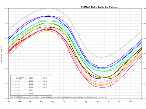
During February of 2016, new record lows in sea ice extent and area
were breached. Meanwhile, sea ice volume — as measured by PIOMAS —
also greatly declined to hover just above previous record lows for
this time of year set in 2011.
(Arctic
sea ice volume, as measured by the
Polar Science Center,
plunged back to near record low territory during February. Many
consider sea ice volume to be the key measure determining sea ice
health. So these new drops in the volume measure are a bit
spine-tingling. Image source: Wipneus.)
Looking
at the above graph, provided
by Wipneus,
and based on model and observation data collected by the
Polar Science Center,
it appears that for some days during February, volume measurements
even briefly descended into record low territory. As of early March,
volume totals were in the range of just above 20,000 cubic kilometers
— beating out 2012 as second lowest volume on measure and hovering
just above 2011.
Winter
Warming Grand Final
Over
the past ten days, abnormal warmth in the Arctic has faded somewhat.
The lower Latitudes have heated up with the onset of spring and this
has tended to strengthen the circumpolar winds. Perhaps the last bit
of seasonal change that can have this effect given the alterations to
atmospheric circulation produced by a human-forced warming of the
globe and a particular high concentration of this added heat
centering on the Arctic.
Ironically,
the time-frame of late February to mid-March is when the higher
Latitudes in the Northern Hemisphere tend to experience their coldest
temperatures. During 2016, we did see some of this atmospheric effect
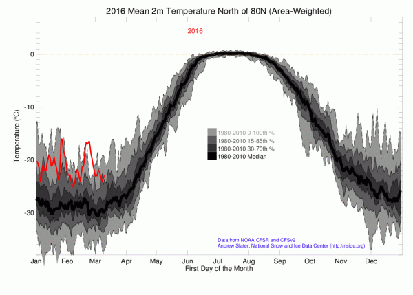
take hold. As a result, temperatures in the High Arctic above the 80
degree North Latitude line have fallen from record warm readings in
late February to far above average warm temperatures over recent
days.
(Ever
since Early January, Arctic temperatures have been in near record or
record warm ranges. This consistent heat has resulted in the warmest
Winter temperatures ever experienced for the region above the 80
North Latitude Line. Image source: CIRES/NOAA.)
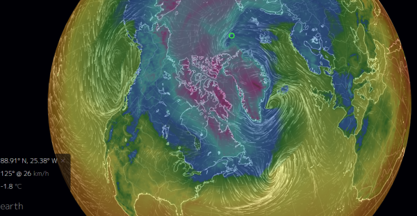
Today, another
very strong pulse of warmth is building up through the region of the
Barents and Greenland seas.
This heat pulse representing yet another warm wind event for 2016.
Another very strong south to north atmospheric draw flooding in front
of yet another chain of strong low pressure systems in the North
Atlantic. A flow of heat drawn up from the tropics and delivered to
the Arctic that will briefly drive regions near the North Pole above
the -2 C melting point of sea ice even as a wide wedge of 20 degree
Celsius above average temperatures invades a region stretching from
Northeast Greenland to the North Pole and back to the isle of Novaya
Zemlya in Russia.
Overall,
the sea ice in this region is much weaker than normal. Volume is
greatly thinned as both the relentless heat influxes and strong sea
ice export through the Fram Strait this Winter has leeched the area
of thick ice. Most sea ice measures show a loss in concentration and
volume for this area. But we’ll know more as the Earth tilts back
toward the sun and
visible satellite coverage again
takes in the entire Arctic.
Given
atmospheric changes taking place with Spring — where Continental
and lower Latitude warming hold greater sway over atmospheric
circulation — this may be the last burst of heat we see through
this zone that produces such high temperature anomalies. A grand
finale for the record warm Arctic Winter of 2016.
(Warm
North Atlantic Winds are predicted to blow into the Arctic yet again
on Saturday, March 12. These winds will push temperatures over a
broad region of sea ice to near freezing, driving such anomalously
warm temperatures all the way to the North Pole. Image source: Earth
Nullschool.)
To
be clear, long range model forecasts do identify far above average
sea surface temperatures and above average 2 meter air temperatures
for this region through Spring and on into Summer. However, the
Arctic overall is not as capable of producing such high temperature
anomalies during Summer as it is during Winter when the human
supplied greenhouse gas overburden and the related warming of the
oceans holds a much stronger sway — re-radiating an insane amount
of heat throughout the long polar night.
High
Arctic Temperature Anomalies Predicted to Fall-off For a Short While,
Melt Potential Through Summer Looks Rather Bad
To
this point, it appears the Arctic may be in for a brief respite on
the 3-7 day horizon. GFS
model runs indicate overall cooling for the region above the 66 North
Latitude line and
temperatures above 80 North may see their first period of near
average temperatures since late December of 2015. This respite for
the High Arctic, though, comes as temperatures in the Sea of Okhotsk,
the Bering, and along Hudson Bay are expected to warm.
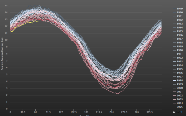
(Arctic
sea ice area remains at record low levels during March of 2016. Image
source:Cryosphere
Today.)
It’s
a mixed signal that may continue some of the very slight Arctic sea
ice rejuvenation we’ve seen during March — with sea ice area
still in record low territory, but with sea ice extent edging back to
second lowest on record and just slightly above 2015.
To
be clear, we’re at a very low launching pad for the start of melt
season in 2016. Record low or near record low sea ice volumes in
February and continuing record low area show that sea ice resiliency
is pretty terrible at this time. Furthermore, Northern
Hemisphere snow cover totals also at or near new record lows hint
that warming of the land masses surrounding the Arctic may be very
rapid come mid to late March and throughout April. To
this point, 10 day Euro model runs show
a tendency for rapid warming over the Northwest Territories, Alaska,
the Bering Sea, the Sea of Okhotsk, the East Siberian Sea, and far
Eastern Siberia during this period even as the thaw line pretty much
everywhere jumps swiftly northward.
A
fading record El Nino in the Eastern Pacific will also tend to result
in ample excess Equatorial heat heading northward. As a result, the
overall risk of strong sea ice melt through the Summer of 2016
remains very high.
Links:


No comments:
Post a Comment
Note: only a member of this blog may post a comment.