

Arctic Sea Ice At Record Low
5
January, 2015
Arctic
sea ice extent on January 4, 2016, was at a record low for the time
of the year, as illustrated by the image below.

Arctic
sea ice will typically reach its maximum extent in March. In March
2015, sea ice extent was very low (see blue line in above image),
and the outlook for this year is even more grim.
Below is a
comparison of sea ice thickness (in m) on January 4th for the years
2012, 2015 and 2016.

The
situation is dire and calls for comprehensive and effective action
as described at the Climate
Plan.
5
January, 2015
Arctic
sea ice extent on January 4, 2016, was at a record low for the time
of the year, as illustrated by the image below.

Arctic sea ice will typically reach its maximum extent in March. In March 2015, sea ice extent was very low (see blue line in above image), and the outlook for this year is even more grim.
Below is a comparison of sea ice thickness (in m) on January 4th for the years 2012, 2015 and 2016.

The situation is dire and calls for comprehensive and effective action as described at the Climate Plan.
One Week After Frank, Arctic Sea Ice Hits New Record Lows
5
January, 2015
Extreme
weather and climate change. The plight of human civilization facing
loss of coastlines, stable climates, and predictable growing seasons.
The plight of the polar bear. How are they all linked? Well, for one,
it now appears that one of the most powerful storms to strike Iceland
— an
extraordinarily intense 928 mb low pressure system dubbed Frank by
the UK Met Office —
has played its hand in helping to drive Arctic sea ice to new daily
record lows.
The
storm, associated with a powerful high amplitude wave in the Jet
Stream, aided in shoving some of the warmest temperatures ever
recorded over the North Pole. Setting off a rare period of above
freezing temperatures during polar night, this extreme weather event
dumped an unprecedented amount of heat into the Arctic during what is
typically its coldest season.

(Dr.
Jeff Masters, chief
meteorologist at Weather Underground,
explains how extreme weather and weaknesses in the Jet Stream
recently contributed to record warming and above freezing
temperatures at the North Pole last week. Image source: Voice
of America News Screenshot.)
It’s
the kind of atmospheric heat engine whose climate and weather
altering impacts I discussed with Dr. Jeff Masters, Dr Steven
Amstrup, and the hosts of Voice of America’s news show #Hashtag —
Michael Lipin and Andrew Palczewski — today.
The kind of extreme events that become more and more common as the
world warms up, dumping an inordinate amount of latent heat into
storms as they form and intensify.
But
this particular event’s far-ranging impact could also be seen in a
warm temperature shift for the High Arctic during Winter. A shift
that brought with it a flatlining of Arctic sea ice accumulation.
Typically,
during December and on through mid-April, Arctic sea ice area and
extent values continue to rise. The cold of polar night settles in
over a broad area of water. Bereft of the heating rays of the sun and
typically plunged into temperatures well below freezing, the ocean
surface becomes covered in an expanding cap of ice. There it provides
a stable environment for so many Arctic creatures that have made that
place their home. But it has also helped to provide the stable
climate of the Holocene — in which for more than 10,000 years human
beings and our civilizations have been able to thrive.
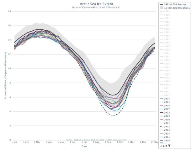
(Red
flat line in the upper left shows that 2016 is starting off in the
range of new record daily lows for Arctic sea ice. It’s one of the
best barometers for climate change impact in the Northern Hemisphere
and one that is still showing new declines, even in Winter. Image
source: NSIDC.)
This
year’s massive Arctic warm-up, in association with Frank, appears
to have stranded that essential ice accumulation in dead stop. And as
of January 4th, according
to the National Snow and Ice Data Center,
Arctic sea ice extent totals remained at 12.8 million square
kilometers. That’s about 90,000 square kilometers below the
previous record daily low set on the same day just five years ago
during the Winter of 2011. It’s also an extent value fully 1
million square kilometers, an area the size of Texas and Montana
combined, below the already depleted 1981 to 2010 average.
Cryosphere
Today showed Arctic sea ice area also following that ominous flatline
pattern —
hitting 12.23 million square kilometers in coverage or the second
lowest area on record for the day.

(Extreme
Arctic warmth on January 5 of 2016 coincides with some extraordinary
global heat in the above temperature anomaly map. It’s just one
more day in a recent severe spate of Arctic warming that has helped
to shove Arctic sea ice into new record low territory over recent
days. Image source: Climate
Reanalyzer.)
Continued
warmer than normal temperatures in the Arctic in the range of 3 to
3.5 C above average for the region may well continue to drive this
sea ice flat line over at least the next couple of days, pushing area
measures into new record low readings even as extent continues to
break records.
Failure
to freeze during Winter is one of the driving factors of major Arctic
sea ice declines during Summer (often
called Winter power over at the Arctic Sea Ice Blog).
So with sea ice hitting new lows for a, much warmer than normal cold
season, we may need to watch out for potential new major losses come
summer time. And that’s bad news for everyone — seals, walruses,
polar bears, human beings and for many of the creatures below the
Arctic Circle that rely on that frozen region for the maintenance of
the climate they evolved and adapted to live in. Dr.
Steven Amstrup, who has been a fearless advocate for the innocent
creatures most likely to be impacted early by human-forced warming of
the Arctic,
I’m pretty sure, would agree.
Links:
Scientific
Hat Tip to Dr Steven Amstrup and Dr Jeff Masters
Hat
Tip to Michael Lipin and Andrew Palczewski
Hat
Tip to Kevin Jones for helping me keep my eye on the ball
One Week After Frank, Arctic Sea Ice Hits New Record Lows
5 January, 2015
Extreme weather and climate change. The plight of human civilization facing loss of coastlines, stable climates, and predictable growing seasons. The plight of the polar bear. How are they all linked? Well, for one, it now appears that one of the most powerful storms to strike Iceland — an extraordinarily intense 928 mb low pressure system dubbed Frank by the UK Met Office — has played its hand in helping to drive Arctic sea ice to new daily record lows.
The storm, associated with a powerful high amplitude wave in the Jet Stream, aided in shoving some of the warmest temperatures ever recorded over the North Pole. Setting off a rare period of above freezing temperatures during polar night, this extreme weather event dumped an unprecedented amount of heat into the Arctic during what is typically its coldest season.
(Dr. Jeff Masters, chief meteorologist at Weather Underground, explains how extreme weather and weaknesses in the Jet Stream recently contributed to record warming and above freezing temperatures at the North Pole last week. Image source: Voice of America News Screenshot.)
It’s the kind of atmospheric heat engine whose climate and weather altering impacts I discussed with Dr. Jeff Masters, Dr Steven Amstrup, and the hosts of Voice of America’s news show #Hashtag — Michael Lipin and Andrew Palczewski — today. The kind of extreme events that become more and more common as the world warms up, dumping an inordinate amount of latent heat into storms as they form and intensify.
But this particular event’s far-ranging impact could also be seen in a warm temperature shift for the High Arctic during Winter. A shift that brought with it a flatlining of Arctic sea ice accumulation.
Typically, during December and on through mid-April, Arctic sea ice area and extent values continue to rise. The cold of polar night settles in over a broad area of water. Bereft of the heating rays of the sun and typically plunged into temperatures well below freezing, the ocean surface becomes covered in an expanding cap of ice. There it provides a stable environment for so many Arctic creatures that have made that place their home. But it has also helped to provide the stable climate of the Holocene — in which for more than 10,000 years human beings and our civilizations have been able to thrive.
(Red flat line in the upper left shows that 2016 is starting off in the range of new record daily lows for Arctic sea ice. It’s one of the best barometers for climate change impact in the Northern Hemisphere and one that is still showing new declines, even in Winter. Image source: NSIDC.)
This year’s massive Arctic warm-up, in association with Frank, appears to have stranded that essential ice accumulation in dead stop. And as of January 4th, according to the National Snow and Ice Data Center, Arctic sea ice extent totals remained at 12.8 million square kilometers. That’s about 90,000 square kilometers below the previous record daily low set on the same day just five years ago during the Winter of 2011. It’s also an extent value fully 1 million square kilometers, an area the size of Texas and Montana combined, below the already depleted 1981 to 2010 average.
Cryosphere Today showed Arctic sea ice area also following that ominous flatline pattern — hitting 12.23 million square kilometers in coverage or the second lowest area on record for the day.
(Extreme Arctic warmth on January 5 of 2016 coincides with some extraordinary global heat in the above temperature anomaly map. It’s just one more day in a recent severe spate of Arctic warming that has helped to shove Arctic sea ice into new record low territory over recent days. Image source: Climate Reanalyzer.)
Continued warmer than normal temperatures in the Arctic in the range of 3 to 3.5 C above average for the region may well continue to drive this sea ice flat line over at least the next couple of days, pushing area measures into new record low readings even as extent continues to break records.
Failure to freeze during Winter is one of the driving factors of major Arctic sea ice declines during Summer (often called Winter power over at the Arctic Sea Ice Blog). So with sea ice hitting new lows for a, much warmer than normal cold season, we may need to watch out for potential new major losses come summer time. And that’s bad news for everyone — seals, walruses, polar bears, human beings and for many of the creatures below the Arctic Circle that rely on that frozen region for the maintenance of the climate they evolved and adapted to live in. Dr. Steven Amstrup, who has been a fearless advocate for the innocent creatures most likely to be impacted early by human-forced warming of the Arctic, I’m pretty sure, would agree.
Links:
Scientific Hat Tip to Dr Steven Amstrup and Dr Jeff Masters
Hat Tip to Michael Lipin and Andrew Palczewski
Hat Tip to Kevin Jones for helping me keep my eye on the ball
No comments:
Post a Comment
Note: only a member of this blog may post a comment.