Severe
thunderstorms, hailstones and tornadoes hit Sydney


16 December, 2015
POLICE have given those people in the path of today’s double whammy of storms across NSW a simple message: go home
POLICE have given those people in the path of today’s double whammy of storms across NSW a simple message: go home
.
Fearful of traffic chaos as commuters clog up flooded streets and roads strewn with debris, NSW Police have advised people to end the day as soon as possible. In a tweet this afternoon the police said they were “encouraging people to leave work early to avoid possible traffic & transport delays”.
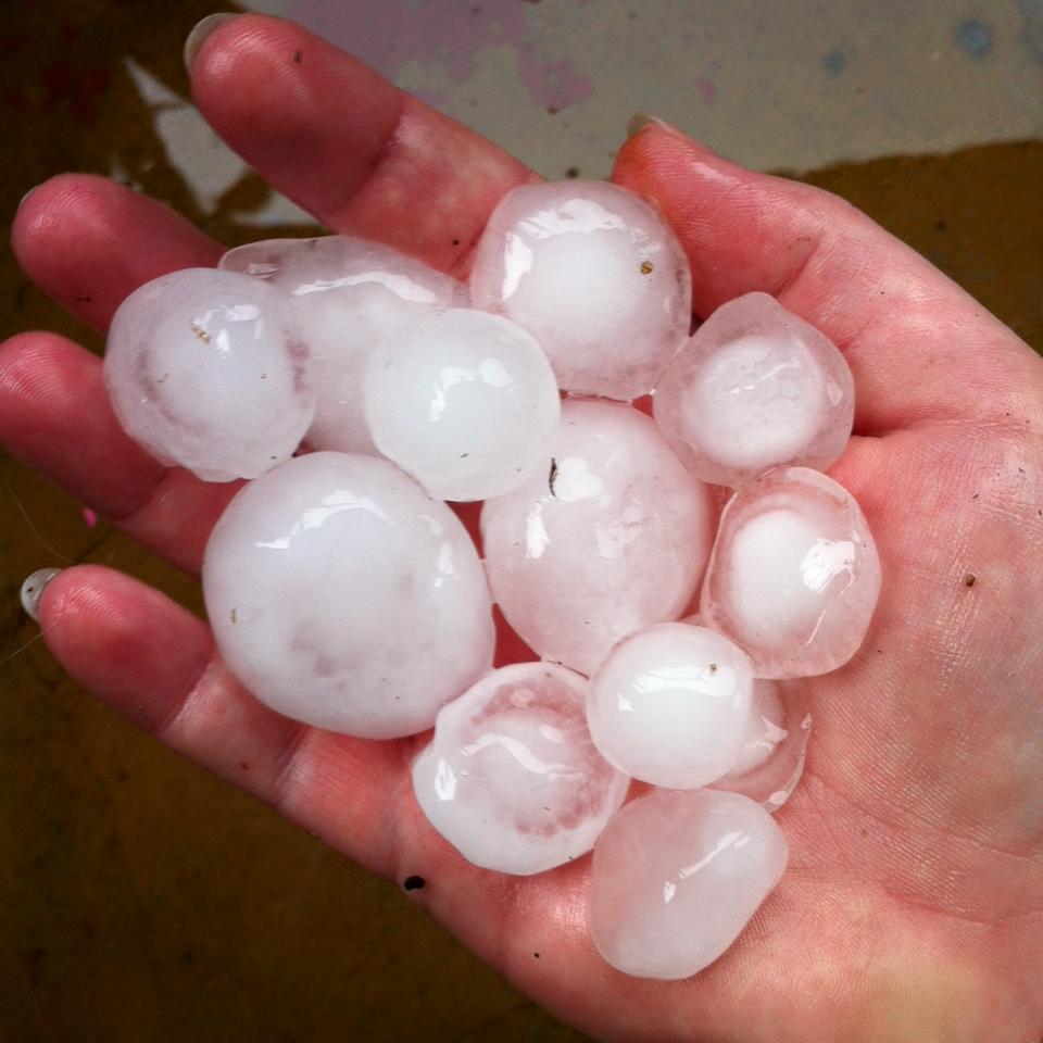
The advice follows Sydney being slammed by two storms in just three hours with hail the size of cricket balls falling in the city’s southern suburbs and a tornado spotted at Kurnell, on the shores of Botany Bay.
Heavy rain also lashed the city’s eastern suburbs with part of the roof of the Westfield Bondi Junction shopping centre caving in. The collapse occurred above Event Cinemas, leaving the ground floor covered in water about 1.15pm, reported theWentworth Courier.
In the devastated southern suburb of Kurnell, where the first storm hit with a bang midmorning, the NSW Riot Squad has been called to help distressed residents access to their homes.
Police said the squad’s four wheel drive vehicles were proving vital to get in and out of the shattered suburb which was hit by tornado force winds of more than 200km/h.
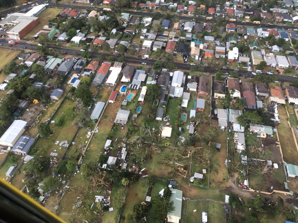
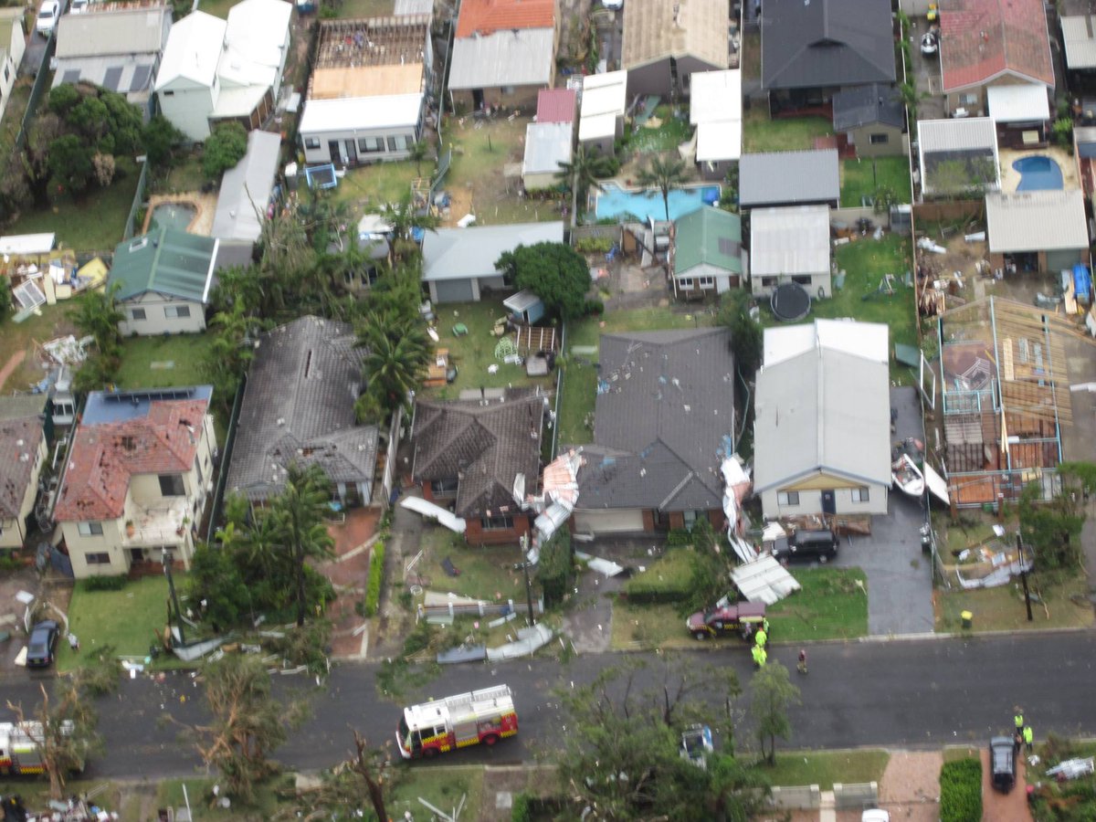
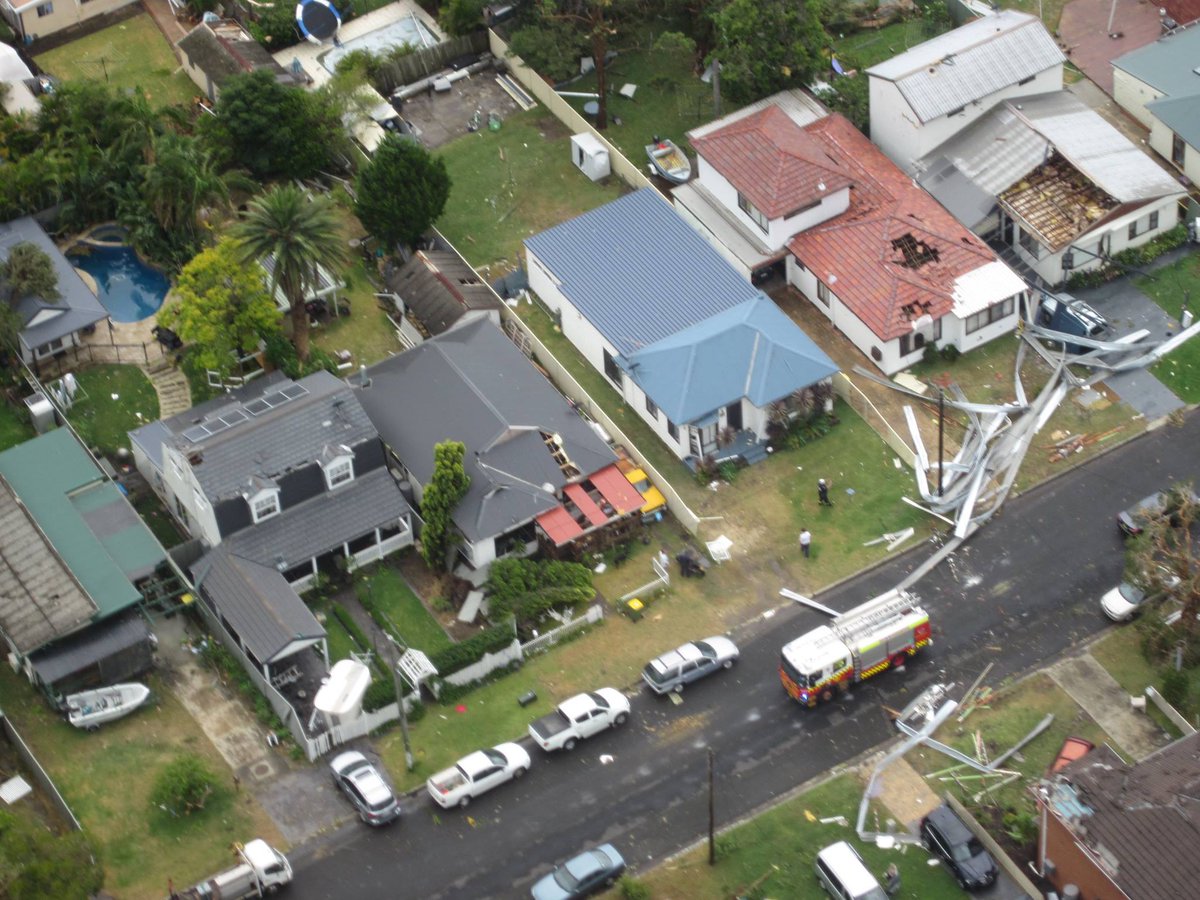
Storm damage in Kurnell, southern Sydney, after a severe thunderstorm swept through the city. (AAP Image/Westpac Life Saver Rescue Helicopters)Source:AAP
Fire and State Emergency Service crews are going from house to house to check on people after tornado strength 200km/h winds tore through the suburb, the area now being declared a disaster zone.
“It is what’s called a super cell thunderstorm and they’re one of the most dangerous thunderstorms we get,” the Bureau of Meteorology said.
Severe thunderstorms hit central Sydney, Sydney Airport and waters off Bondi Beach around 1.30pm and Sydney Olympic Park and Wyong at around 2pm. Destructive winds and very heavy rainfall were followed by flash flooding particularly in the city’s east.
Pedestrians stand on top of a bus stop seat in Randwick, eastern Sydney, as flood water rages below them. Picture: Julia Wheeler
The BoM has said while the threat of severe storms has eased, major thunderstorms are still a real possibility and warnings remain current for is also current for the entire NSW coast between the Illawarra and Hunter, the Mid North Coast, Central Tablelands and parts of the southern Tablelands, North West Slopes and Plains, Central West Slopes and Plains, South West Slopes and Northern Tablelands districts.
Earlier in the day, thunderstorms, hailstones and high winds hit Cronulla and Kurnell in Sydney’s south before passing through the city, Bondi Beach and heading towards Hornsby and the Northern Beaches. A wind gust of 213km/h was reported at Kurnell at around 10.30am.
Severe Weather Forecaster at the BoM, Michael Logan, said the storm was out of character as it began in the morning, not the afternoon, and because it came from the sea to the coast and didn’t develop over land.
“The storm situation today was dangerous and relatively unusual, due to the storms’ strength, the time of day they occurred, their direction of movement, and the probable occurrence of tornadoes,” he told news.com.au.
“The intensity of the storm as detected on radar combined with the wind gust at Kurnell suggest a tornado was likely associated with this very severe thunderstorm.”
The State Emergency Service said it had received more than 160 call outs, with 65 alone from the Sutherland Shire, where Cronulla and Kurnell are located.
Some 7000 businesses are without power, including Kurnell Public School. The desalination plant in Kurnell was evacuated after reportedly sustaining significant damage and workers were also cleared out of the Caltex refinery.
A 40-year-old man suffered head injuries in Kurnell and Ambulance NSW said officers treated two other people, all of whom were transferred to Sutherland Hospital in a stable condition.
A balcony in Maroubra in Sydney’s eastern suburbs collapsed and the roof of a unit was damaged as storms travelled north.
There are reports a roof has collapsed on a home in Kurnell with two people trapped inside.
A spokesman from NSW Ambulance Service confirmed they were responding to a “structural collapse” at a property on Bridge St.
Water half a metre deep has also been reported near Cronulla High School with live wires down.
Sydney airport was closely monitoring the storm activity with passengers being advised to check flight details with their airlines, an airport spokeswoman said. Flights from Melbourne and the Gold Coast are among those delayed by Qantas, Virgin Australia and Jetstar.
Transport for NSW says buses in and around Kurnell and the city’s east were being delayed due to flooded streets.
Beth, who lives and works in Cronulla in the city’s south, said “golf ball-size hail” fell on St Andrew’s Anglican Church.
“We had some brownouts, lots of thunder and lightning, and some large hail,” she said.
“The wind was strong and it was hitting our glass windows. I have a big dint in the front of my car.”
A severe storm has passed through Sydney, Maroubra was also hit at the height of the storm. Picture: John GraingerSource:News Corp Australia
Pictured at The Rocks, a storm rolls through Sydney's Eastern Suburbs coast. Picture: Richard DobsonSource:News Corp Australia
Balcony windows on the top floor of 14 Bellevue St, Maroubra after the tornado like winds went through the coastal areas of southern Sydney. Picture: John GraingerSource:News Corp Australia
A massive storm front is pictured over Sydney Harbour. Picture: Twitter/Julian RiddenSource:Twitter
The State Emergency Service said people should move cars under cover or away from trees, secure or put away loose items around the house, yard and balcony, keep clear of fallen power lines, creeks and storm drains and don’t go through flood waters.
Three separate storms converged on Sydney. Picture: BoM
It also said to avoid using phones during the storm, stay indoors away from windows, and keep children and pets indoors.
Warwick, in south west Queensland’s Darling Downs has also been hit by storms and heavy rain.
Kurnell, in the southern suburbs of Sydney has been particularly badly affected
Kurnell storm damage December 2015
https://en.wikipedia.org/wiki/Kurnell,_New_South_Wales
Ariel photos of the current scenes at #Kurnell. Most damage has occurred particularly around Bridges Street.
Kurnell has been by far the worst hit in today’s storm.
“It
is so very rare to get a tornado inside Sydney, much less a strong
tornado,” a BOM spokesman said.
Gusts
in Kurnell reached up to 213km/h. “That is the fastest speed that
has been recorded in NSW history,” he said.
An
evacuation centre for Kurnell residents has been set up at the
Cronulla Leagues Club on Captain Cook Drive, in the Sutherland Shire.
Injuries
are minimal but three ambulances have been sent to the Kurnell Public
School as a precaution “in anticipation of a second storm”, an
ambulance spokesman told AAP.
A
40-year-old man in Kurnell suffered head injuries after reports of
storm damage to a building, a 38-year-old man was treated for shock
and another patient was treated for an unspecified conditio.
A
75-year-old woman received cuts to her leg, while a man was struck by
debris and an elderly man was treated for anxiety.
All
patients have been taken to Sutherland Hospital in a stable
condition.


 SutherlandShireNews


 Rebecca Murphy


No comments:
Post a Comment
Note: only a member of this blog may post a comment.