California
braces for fiercest storm in 5 years
A ferocious storm is forecast to batter California with drenching rain, heavy snow, pounding surf and howling winds through Friday.
10
December, 2014
The
National Weather Service said the barrage is "expected to be one
of the strongest storms in terms of wind and rain" since storms
in October 2009 and January 2008.
In
Northern California, where the rain was expected to hit first,
officials in San Francisco, Oakland and Marin County said schools
would be closed Thursday because of expected heavy rain and winds.
Southern
California saw dark clouds move in Wednesday afternoon. Los Angeles
County officials closed a pair of main roads around Castaic Lake, a
state recreation area in mountains north of Santa Clarita, in
anticipation of mud flow.
A
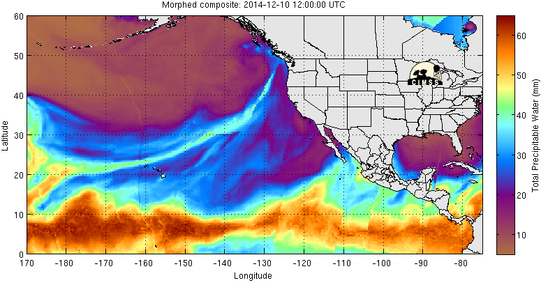
system fueled by the "Pineapple Express" is delivering a
steady stream of moisture directly from Hawaii to the West Coast
starting Wednesday. Meteorologists describe the Pineapple Express as
a long, narrow plume that pipes moisture from the tropics into the
western United States.
About
3-6 inches of rain is possible in parts of Northern California,
including much of the San Francisco Bay Area and Sacramento,
AccuWeather said. Some spots could see as much as 9 inches of rain.
The
rainfall could overwhelm waterways and road drainage systems,
possibly leading to flash floods.
RT
@amhq:
#Snow is bookending the US! We're talking about all the snow &
#rain in the west & how it'll impact drought.
In
the Sacramento area, strong winds expected with the storm — gusts
as high as 60 mph — could take down outdoor holiday decorations.
"I'm
not putting any of it up until after the storm because even though
it's pretty durable, it will just blow over," Sacramento
resident Tim Adams said.
People
were advised to take down their holiday lights, especially inflatable
decorations that are not properly anchored.
Mark
Ghilarducci, director of the California Governor's Office of
Emergency Services, issued a warning that the storm will present a
risk of flash flooding and debris slides, particularly in the
northern and southern areas of the state that had wildfires this
year.
"Burned
areas are especially at risk for debris slides. Even regions that
don't experience regular seasonal flooding could see flash flooding
during this intense storm system," he said in a statement.
Shannon Rae Green interview Weather reporter Doyle Rice on the storm headed for the West Coast, and about how the system got its funny name. (News, USA TODAY)
The
intense rain from this storm still won't end the region's drought,
although it will be a major step in the right direction, AccuWeather
meteorologist Alex Sosnowski said.
Runoff
from the storm could cause streams to surge with high water before
eventually emptying into lakes and reservoirs.
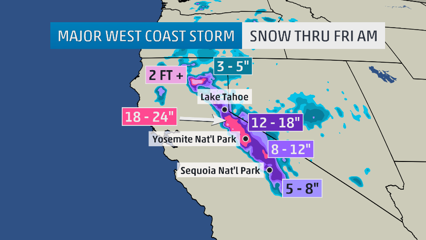
As
much as 4 feet of snow could fall in the Sierra Nevada. A blizzard
warning was posted for portions of the northern Sierra, where winds
could rage to 80 mph with heavy, swirling snow. A winter storm
warning is also in effect for the southern Sierra.
Tons of rain and snow coming on Thursday!
#pineappleexpress #droughtrelief
The
weather service warned that travel in the northern Sierra will be
"extremely dangerous" because of blizzard conditions: "Do
not travel. If you must travel, have a winter survival kit with you.
If you get stranded ... stay with your vehicle."
The
storm is expected to dump enough snow on California's mountains that
the state's snowpack — currently only 35% of average for this time
of year — could be at 75% or higher by this weekend.
Oregon
and Washington were the first to see the storm's effects Wednesday.
At least 24,000 customers had lost power by Wednesday afternoon
because of the rain and wind in western Washington, with more outages
and rough weather forecast through Thursday.
Oddly,
along with the rain in Washington came warmth, as Sea-Tac Airport hit
66 degrees, the highest December temperature ever recorded there,
according to the weather service.
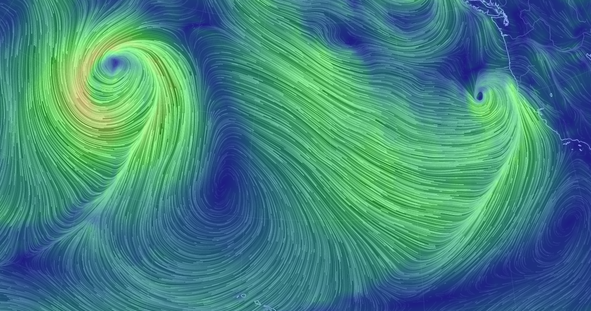
MT
@NWSBayArea: Cool wind map Thurs AM shows storm off of CA coast. Animation:
http://bit.ly/1siToc3 Pic:
UK:
Power restored as 'weather bomb' storm subsides
Power
has been restored to the vast majority of the 31,000 homes that had
their supply cut as Scotland was hit by a storm dubbed the "weather
bomb".
10
December, 2014
Energy
firm SSE said its engineers had reconnected 28,000 homes by 16:30,
with a further 2,800 still without power.
Much
of western and northern Scotland has been battered by wind and rain.
A
wind speed of 144mph was recorded on the remote St Kilda islands,
with gusts in excess of 80mph elsewhere.
Met
Office amber "be prepared" warnings for the west coast and
the Highlands and Islands were downgraded to yellow at 18:00 on
Wednesday.
The
yellow "be aware" alerts of wind, which cover the whole of
Scotland, will remain in place until 10:00 on Thursday.
Ferry
operator CalMac has said many of its services were likely to still be
disrupted on Thursday.
An
RNLI crew man who helped rescue a trawler off the coast of Orkney
says the waves are "as bad as we've seen it"
The
Western Isles, Shetland, Orkney and parts of Argyll and Lochaber were
among the worst areas affected on Wednesday, as heavy rain, strong
winds and lighting strikes left homes without power.
But
disruption in much of the rest of the country was not as bad as had
been feared.
SSE
said about 900 customers were still without power in the Western
Isles - which was left completely without electricity for a time -
along with a further 270 in Shetland, 100 in Orkney, 500 in the Fort
William area, 570 in Dunoon and 245 in the Oban area.
The
weather was also affecting a number of other areas, causing minor
damage to the electricity network.
SSE
said its 500 engineers and support staff would continue working late
into the night to ensure power was restored to all of the remaining
households.
But
it said repairs were taking longer due to the nature and complexity
of the damage to the network in some places, with engineers having to
contend with rain, snow, and strong winds as well as damage caused by
lightning strikes.
 Barra felt the brunt of the 'weather bomb' storm
 A Caledonian MacBrayne ferry braves the storm as it leaves Ardorssan harbour
 Storms north of Yesnaby in Orkney
There
were also early-morning blackouts in Renfrew, Penicuik and West
Linton but power was restored by 11:30.
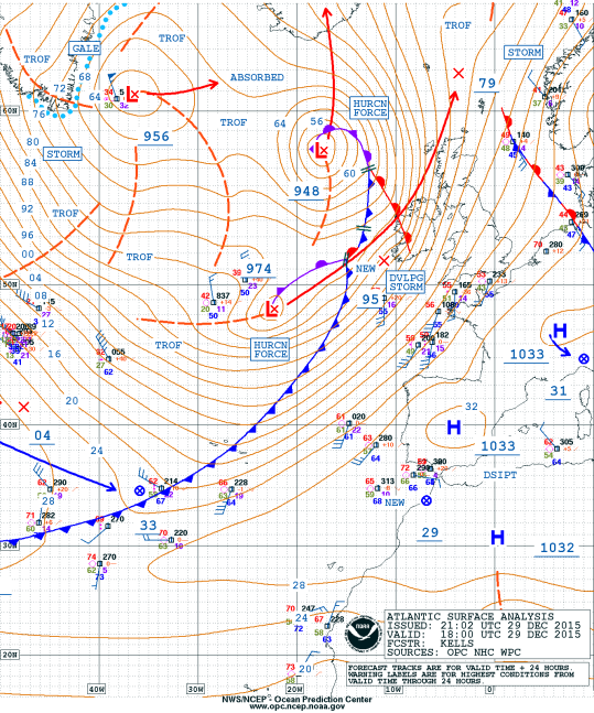
The
rapid cyclogenesis - known colloquially as a "weather bomb"
- is a deep, low-pressure system which was moving slowly eastwards
between Scotland and Iceland.
A
series of flood warnings and alerts were also issued by the Scottish
Environment Protection Agency (Sepa), but there have been no reports
of major flooding.
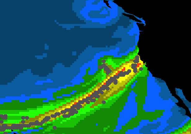
 This BBC graphic shows the wind strengths and wave heights from the "weather bomb"
-
The
strongest wind gusts recorded so far have been 144mph on St Kilda,
with South Uist at 82mph, Tiree 81mph and Islay 77mph.
Gusts
of up to 80mph at the top station of the Cairngorm Funicular
Railway.
The
wind speed at Machrihanish on the Kintyre peninsula was recorded at
73mph, Stornoway on Lewis 69mph, and Oban 63mph.
The
highest low-level gust so far was 79mph at Benbecula.
All
schools, nurseries, libraries and council sports facilities in the
Western Isles are closed
Almost
50 schools and nurseries in the Highlands are also closed, affecting
2,312 children.
The
Skye Bridge was closed but is currently open to cars only.
The
Forth Road Bridge, Tay Road Bridge, Erskine Bridge and Dornoch
Bridge are closed to high-sided vehicles and there are warnings on
the Kessock Bridge.
Traffic
Scotland said all trunk roads were open but warned drivers to take
care.
Many
ferries have been cancelled including Cairnryan to Belfast.
Cairnryan
to Larne sailings are operating but with delays of about two hours.
The
Ardrossan to Brodick crossings have been cancelled, as have
Kennacraig to Islay, Barra to Eriskay, Stornoway to Ullapool and
Oban to Craignure.
All
sailings on the Largs-Cumbrae service have also been cancelled due
to high winds.
Orkney
Ferries said all sailings to Westray and Sanday were cancelled for
the day.
Mallaig
to Armadale ferries cancelled today and Thursday.

Trees were brought down in Mount Florida, Glasgow, as the storm hit
The
National Trust for Scotland (NTS) said the wind speed at the top of
the hill on Hirta, the largest of St Kilda's islands, reached 144mph
- one of the highest ever recorded there.
St
Kilda, which is in the care of the NTS, experiences gales on 75 days
of the year, but conditions were said to be even tougher than normal
 The shore at Applecross in Wester Ross took a battering
Earlier,
the Stromness lifeboat was called out after a Spanish fishing boat
radioed in a Mayday after being hit by a large wave off the west
coast of Orkney.
It
is understood the wheelhouse windows of the O Genita trawler were
smashed in the incident, with waves bigger than the height of the
boat.
By
11:40, the trawler was escorted into Pierowall Bay on Westray, by the
lifeboat.
Towering waves crashed onto the cliffs in Orkney
 The O Genita trawler safely reaches Pierowall Bay after sending out a Mayday call
 A boat battles through the waves off the Isle of Lewis
The
Shetland coastguard helicopter, which had been at the scene of the
Mayday call, was forced to land on Westray because of lightning in
the area.
Network
Rail said the vast majority of the train network was running but they
had withdrawn services in the more exposed areas such as coastal
routes and the far north line up towards Wick and Thurso.
A
number of rail services were also withdrawn, with no trains running
on the following lines:
Inverness-Kyle/Thurso/Wick
Ayr-Stranraer
Kilwinning-Ardrossan/Largs
Dumbarton
Central-Helensburgh Central
Glasgow
Queen St-Oban/Fort William/Mallaig (including the Caledonian
Sleeper)
 Crashing waves at Saltcoats
 Looking west from Stronsay High School in Orkney as lightning strikes
About 20 vehicles were stuck in icy conditions at Cairn O' Mount on the B974 Banchory to Fettercairn road in Aberdeenshire for 90 minutes before being moved on at 09:30.
The Vatersay and Eriskay causeways on the Western Isles were closed after being overtopped by waves.
Deputy
First Minister John Swinney told BBC Radio Scotland early on Thursday
morning: "It is important to keep this in context. It's not a
surprise that Scotland faces severe winter weather, we face it to a
greater or lesser extent every year. This morning we're wrestling
with a number of different issues.
"We're
wrestling with very high wind speeds, which are not that uncommon in
the Western Isles for example, but they are still severe and need to
be prepared for.
"We're
wrestling with the possibility of coastal flooding because of the sea
surges and strength of waves that are likely to come, and in other
parts of the country we're wrestling with the issues of snow on the
A9 and M74 and we also will, I suspect, be dealing with a bit of
flooding on some of the river systems in Scotland but mainly on
agricultural land.
Mr
Swinney added: "I think it's important to remember that this is
weather which is characteristic of winter weather in Scotland and
what's important is that we take the necessary steps to prepare for
it."
 The location of lightning strikes over Scotland since midnight with thousands of homes affected by power cuts
 A chart showing the movement of swells of up to 40ft from 06:00 to 15:00 on Wednesday
US: Winter
Storm Damon: Nor'easter Brings Snow, Heavy Rain, High Winds, Coastal
Flooding (FORECAST)
10
December, 2014
Winter Storm Damon continues to churn over the Northeast, and a second pulse of atmospheric energy arriving from the west is breathing new life into this extremely slow-moving nor'easter.
Areas hard-hit by Superstorm Sandy two years ago were among the first to face Damon's fury, as Tuesday morning's high tide brought minor to moderate coastal flooding to the Jersey Shore and parts of Long Island. In some areas, tides reached their highest levels since Sandy, but impacts were far less damaging this time around.
Rainfall added to the flood woes near the coast Tuesday, while ice slickened roads farther inland. Going forward, however, the biggest impact from Damon will be snow.
The Setup
Low pressure formed along the western end of an old stalled frontal boundary off the Mid-Atlantic coast. It is heading north toward New England, but it may take some time to get there as it stalls out near Long Island overnight into Wednesday.
A second batch of upper-atmospheric energy will arrive from the west, injecting fresh energy into this storm and forcing the low to lift a bit farther north or even northwestward into New England.
This second surge of energy will also reinvigorate the storm's precipitation shield, leading to an increase in snowfall by Wednesday night and Thursday in parts of the interior Northeast and southeast Canada.
One challenge with this system, as with most Northeast coastal storms, has been the availability and location of cold air.
Despite the passage of a cold front through the Northeast this past weekend, the path of this coastal low dislodged the cold air (translation: air below freezing near the surface) from a significant swath of the Northeast, especially New England, causing snow and ice to change over to rain in many areas Tuesday night.
However, on Tuesday morning, before the cold air was dislodged, up to a quarter of an inch of freezing rain was reported in Milford, New Jersey and Allamuchy, New Jersey where power lines came down. Icy conditions were also found in parts of Massachusetts where numerous car accidents occurred.
Current Radar and Lightning
Rain and Snow Forecast
Our latest forecast additional rain and snow totals through Thursday. Note that some in the accumulating rainfall area may also see non-accumulating snowfall.
Heavy Rain Threat
The heaviest rain has already ended across the region but showers will be found from Philadelphia northward to New York City and southern New England. Another round of steady rain is expected farther north in Maine and northern New Hampshire on Wednesday.
Tuesday's rainfall set daily records in, among other places, New York City (2.54 inches at Central Park); Providence, Rhode Island (2.74 inches); and Boston (2.90 inches).
How Much Snow?
On the western flank of the storm, rain has changed over to snow, as cold air aloft chills the column of air north and west of the I-95 corridor. Lingering pockets of snow are possible into Thursday, especially southeast of Lake Erie and Lake Ontario with some lake enhancement to the snowfall.
Snowfall totals from Boston to New York, Philly and Washington, D.C. are expected to be minimal, if they occur at all.
The heaviest snowfall potential will line up over the interior Northeast from northern Pennsylvania into much of upstate New York, the Green and White Mountains of Vermont and New Hampshire, and into northern Maine. Some of the higher elevations mentioned above may tally up to 2 feet of total snow, including what's already fallen, through Thursday.
Heavy snow will also continue to affect areas across the border in southeastern Canada.
Much of this snow is of the heavy, wet variety, making it difficult to shovel, and more prone to break tree limbs and cause power outages.
Some of the heavy snow that fell in northern Maine, however, is being melted by rainfall and above-freezing temperatures. Farther west, particularly in upstate New York, the heaviest snow will not be followed by rain or above-freezing temperatures, so it will stick around longer.
Top reported snowfall totals as of 10 a.m. Wednesday include 20 inches in Jamesville, New York (near Syracuse); 18 inches near Carrabassett Valley, Maine; 17.5 inches on Mount Mansfield in Vermont; 14 inches in Killington, Vermont; 13 inches in Lake Placid, New York, and Pinkham Notch, New Hampshire; and 6 inches in Savoy, Massachusetts.
High Winds
In addition, a pulse of strong winds, with some gusts from 40 to 60 mph, surged northward ahead of the developing low pressure system. This zone of strong winds has lifted from New England into Canada. These winds produced scattered power outages and knocked down tree limbs and weaker trees.
Top reported gusts Tuesday afternoon included 62 mph in Fairhaven, Massachusetts, and 61 mph in Scituate and Falmouth, Massachusetts.
Also, blustery winds wrapping into the cold air from upstate and central New York into central and eastern Pennsylvania through Wednesday may combine with wet, accumulating snow to trigger downed trees, tree limbs and power outages.
This does not appear to be a crippling Northeast snowstorm with feet of snow over a widespread area.
However, snow-covered roads in the interior Northeast will make travel challenging, and hundreds of flight delays and cancellations have been reported across the Northeast.
Coastal Flooding
As low pressure strengthens offshore, it generated a solid fetch of easterly winds blowing onshore across the Mid-Atlantic region. This piled ocean water toward shore, resulting in water levels of 2 to 3 feet above normal astronomical tide.
This resulted in some coastal flooding over the Outer Banks of North Carolina, where a stretch of Highway 12 was affected Monday.
Little Egg Inlet, New Jersey, reached major flood stage at high tide Tuesday morning, reaching its second highest level on record behind only Sandy. The Tuesday morning high tide resulted in minor to moderate coastal flooding along much of the Jersey Shore as well as portions of southern Long Island.
The threat of coastal flooding has lessened and only minor splashover and minor beach erosion was expected along the eastern coast of New England with the high tide cycle on Wednesday morning.
For the remainder of the storm, the strongest winds from Damon (at least in the U.S.) will be blowing offshore, so coastal flooding is no longer a concern.
Check back with us at weather.com and The Weather Channel as we track Winter Storm Damon.

 Posts
Posts