New Orleans battles flash flooding as it faces possible hurricane
City in state of emergency as it prepares for its biggest test since the failure of its flood protection levees during Hurricane Katrina
11 July, 2019
New Orleans is battling flash flooding and is in a state of emergency, on hurricane watch, as the city prepares for its biggest test since the catastrophic failure of the city’s flood protection levees during the deadly Hurricane Katrina, which devastated the city when 80% of it was flooded in 2005.
A huge storm in the Gulf of Mexico was on Thursday expected to tighten into a whirling tempest and gather enough speed to be designated as a named system – in this case storm Barry – as it approaches the coast, with landfall expected on Saturday.
Louisiana on Wednesday declared a state of emergency as the storm was fast developing into a category 1 hurricane.
Experts are warning that the resulting storm surge could push the already swollen Mississippi River precariously close to the tops of levees that protect New Orleans.
The river is expected to rise 19ft by the weekend.
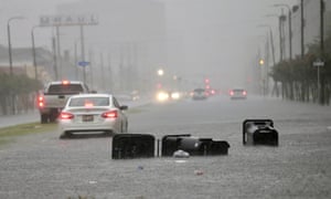
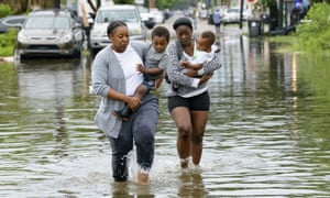
The latest dire forecasts come as the city was already reeling from initial flash flooding earlier on Wednesday. Garbage containers tilted on their sides and pieces of wood floated down rain-swollen streets in a number of neighborhoods.
Water was up to the doors of many cars during the morning rush hour and a waterspout over Lake Pontchartrain, which is directly adjacent to New Orleans, was also spotted in the Gentilly neighborhood.
The morning’s storms were associated with the broader area of disturbed weather over the gulf, which forecasters now believe will organize and strengthen as it moves west through the Gulf’s warm waters.
Tracking forecasts of the storm’s path on Thursday had a mix of predictions that it would either pass to the west of New Orleans when it makes landfall or, more likely at this stage, make a direct hit on the city.
Forecasters say parts of Louisiana could see up to 12in (30.5cm) of rain by Monday, with heavier amounts possible in some spots.
On Wednesday afternoon, Louisiana’s governor, John Bel Edwards, announced a state of emergency across the state that is effective until 8 August unless terminated sooner.
“This is going to be a Louisiana event with coastal flooding and widespread, heavy rainfall potentially impacting every part of the state,” Edwards said in a statement.
“No one should take this storm lightly,” he added. “As we know all too well in Louisiana, low intensity does not necessarily mean low impact.”
He encouraged residents to check their supplies and make emergency contingency plans.
Mississippi and Texas were also at risk of torrential rains.
The National Weather Service said New Orleans is protected to a river level of 20ft (6.1 meters), the same level that it is now forecasting the river to reach by Friday. That would mark the highest river level at New Orleans in nearly 70 years.
The river levels in Louisiana have been high for months due to flooding further upriver in the midwest. The army corps of engineers have been using spillways to divert the river’s flow since May.
Though much of the heaviest rain is not expected until the weekend, by mid-morning as much as 7in of rain had fallen over the metropolitan area. City officials urged residents off the roads, citing “widespread street flooding”,and had suspended all bus and streetcar services. Always at issue in the city, which mostly sits below sea-level, was the status of the 120 pumps used to push rainwater out of the streets. Officials said 118 are online, and that they were “all hands on deck” and “continuing to work this event”.


No comments:
Post a Comment
Note: only a member of this blog may post a comment.