Showing posts with label New Orleans. Show all posts

Thursday, 29 October 2020

Hurricane ZETA is making landfall

LANDFALL! Direct Hit New Orleans; 110 MPH Sustained Winds


Hal Turner,

28 October, 2020


Hurricane ZETA is making landfall in Louisiana from the Gulf of Mexico at this hour, 6:35 PM Eastern US time.  The eye of the storm will begin to pass directly over the city of New Orleans within an hour, with sustained winds of 110 MPH and gusts to 155 MPH.

Storm surge already occurring in the coastal marshlands is showing a ten meter (30 foot) surge of water being driven onshore by the storm!  This catastrophic surge will knock down most buildings hit by it, and make roads completely impassable, preventing residents who chose to stay, from evacuating.  If they stayed, it is too late for them now.

Emergency services are NOT responding to any calls for help in the affected area as it is too dangerous for Emergency Crews to go out; their fire / rescue trucks would be swept away by the storm surge.

Video from an oil rig in the Gulf of Mexico show the ferocious power of this storm.  In the brief video below, you can see FIFTY FOOT TALL WAVES striking the oil rig, and the backwash flowing over the deck which is twenty five feet higher!

This will still be a catastrophic storm when it reaches New Orleans.  It is not known if the city's levee system and flood water pumping system will handle the deluge.

City residents were NOT told to evacuate

Sunday, 14 July 2019

Hurricane Barry makes landfall


It really is only the alternative media who are reporting on the real context of this.The mainstream report the facts in a way to hide the true horror of this.


Hurricane Barry Moving 

Onto Louisiana Coast, All 

New Orleans Flights 

Canceled


Is the mainstream reporting on this?


Levee BREACHES & OVER-

TOPPING ! ! Near New 

Orleans -- Water Pouring-in!


13 July, 2019

A levee has been BREACHED near New Orleans and water is POURING through as of 10:00 AM eastern US time, near New Orleans, LA, and Hurricane Barry has not yet even fully arrived!
The storm reached Hurricane strength this morning and is now a Category 1 Hurricane with maximum SUSTAINED winds of 74 MPH, and gusts to 87 MPH.
Also, at this hour, 63,000  customers are without electric power in Louisiana from the initial bands of the storm -- but the heart of the storm has not yet reached land.
Per the National Hurricane Center "Data from Air Force recon indicates that Barry has become the 1st hurricane of 2019 as it begins to make landfall in central Louisiana this AM."
UPDATE 10:25 AM EDT --
In addition to the breached levee shown above, reports are now coming in from Plaquemines Parish that levees there are being OVER-TOPPED by storm surge.
First responders are battling rising water that is overtopping a back levee system that protects some parts of Plaquemines Parish from coastal flooding.

Plaquemines Parish Homeland Security Director Patrick Harvey tells WWL-TV that crews started seeing overtopping along the back levee system that protects the Myrtle Grove and Pointe Celeste areas off Highway 23 around 5 a.m. 

The levees that are seeing overtopping are separate from the flood defenses that protect the parish from the Mississippi River.
More storm details HERE

UPDATE 10:40 AM EDT --
A levee in Myrtle Grove, which is in lower Plaquemines Parish, has been overtopped due to high water caused byTropical Storm Barry.

Lt. Gov. Billy Nungesser said Saturday morning that water is also flowing over the levees in Jefferson Lake and Point Celeste. Crews are working to contain the water. 

MORE:
The U.S. Coast Guard is mounting a rescue mission to save 12 people trapped in a coastal Louisiana community cut off by rising water from Tropical Storm Barry. (They had previously been told to evacuate but CHOSE not to leave.  Now, others must put THEIR OWN lives in danger to rescue these people. . .

UPDATE 11:00 AM EDT --
Barry is now officially a "Hurricane."  Here's the latest from the National Hurricane Center:

000
WTNT32 KNHC 131454
TCPAT2

BULLETIN
Hurricane Barry Advisory Number  13
NWS National Hurricane Center Miami FL       AL022019
1000 AM CDT Sat Jul 13 2019

...BARRY BECOMES A HURRICANE AS IT IS MOVING ONTO THE LOUISIANA
COAST...
...DANGEROUS STORM SURGE, HEAVY RAINS, AND WIND CONDITIONS
OCCURRING ACROSS THE NORTH-CENTRAL GULF COAST...


SUMMARY OF 1000 AM CDT...1500 UTC...INFORMATION
-----------------------------------------------
LOCATION...29.6N 92.0W
ABOUT 40 MI...65 KM S OF LAFAYETTE LOUISIANA
ABOUT 50 MI...80 KM W OF MORGAN CITY LOUISIANA
MAXIMUM SUSTAINED WINDS...75 MPH...120 KM/H
PRESENT MOVEMENT...NW OR 310 DEGREES AT 6 MPH...9 KM/H
MINIMUM CENTRAL PRESSURE...993 MB...29.33 INCHES


WATCHES AND WARNINGS
--------------------
CHANGES WITH THIS ADVISORY...

A Tropical Storm Warning has been issued for the Louisiana coast
from Cameron to Sabine Pass.

The Hurricane Watch for the Louisiana coast east of Grand Isle has
been discontinued.

The Tropical Storm Watch for the Mississippi coast has been
discontinued.

SUMMARY OF WATCHES AND WARNINGS IN EFFECT...

A Hurricane Warning is in effect for...
* Intracoastal City to Grand Isle

A Tropical Storm Warning is in effect for...
* Mouth of the Pearl River to Grand Isle
* Lake Pontchartrain and Lake Maurepas including metropolitan New
Orleans
* Intracoastal City to Sabine Pass

A Storm Surge Warning is in effect for...
* Intracoastal City to Biloxi
* Lake Pontchartrain

A Storm Surge Watch is in effect for...
* Biloxi to the Mississippi/Alabama border

A Hurricane Watch is in effect for...
* Intracoastal City to Cameron

A Hurricane Warning means that hurricane conditions are expected
somewhere within the warning area.  A warning is typically issued
36 hours before the anticipated first occurrence of
tropical-storm-force winds, conditions that make outside
preparations difficult or dangerous.  Preparations to protect life
and property should be rushed to completion.

A Tropical Storm Warning means that tropical storm conditions are
expected somewhere within the warning area within 36 hours.

A Storm Surge Warning means there is a danger of life-threatening
inundation from rising water moving inland from the coastline
during the next 36 hours in the indicated locations.  For a
depiction of areas at risk please see the National Weather
Service Storm Surge Watch/Warning Graphic available at
hurricanes.gov.  This is a life-threatening situation.  Persons
located within these areas should take all necessary actions to
protect life and property from rising water and the potential for
other dangerous conditions.  Promptly follow evacuation and other
instructions from local officials.

A Storm Surge Watch means there is a possibility of life-
threatening inundation from rising water moving inland from the
coastline in the indicated locations during the next 48 hours.

A Hurricane Watch means that hurricane conditions are possible
within the watch area.  A watch is typically issued 48 hours
before the anticipated first occurrence of tropical-storm-force
winds conditions that make outside preparations difficult or
dangerous.

For storm information specific to your area, including possible
inland watches and warnings, please monitor products issued by your
local National Weather Service forecast office.


DISCUSSION AND OUTLOOK
----------------------
At 1000 AM CDT (1500 UTC), the center of Hurricane Barry was located
near latitude 29.6 North, longitude 92.0 West. Barry is moving
toward the northwest near 6 mph (9 km/h), and a turn toward the
north-northwest is expected tonight, followed by a turn toward the
north on Sunday.  On the forecast track, the center of Barry will
move through southern Louisiana today, into central Louisiana
tonight, and into northern Louisiana on Sunday.

Maximum sustained winds are now near 75 mph (120 km/h) with higher
gusts.  As it moves inland, Barry is forecast to weaken below
hurricane strength in the next few hours, and it is forecast to
weaken to a tropical depression on Sunday.

Hurricane-force winds extend outward up to 45 miles (75 km) to
the east of the center and tropical-storm-force winds extend outward
up to 175 miles (280 km) from the center.  The National Ocean
Service station at Eugene Island, Louisiana recently reported
sustained winds of 62 mph and a wind gust of 82 mph.

The estimated minimum central pressure is 993 mb (29.33 inches).


HAZARDS AFFECTING LAND
----------------------
Key Messages for Barry can be found in the Tropical Cyclone
Discussion under AWIPS header MIATCDAT2 and WMO header WTNT42 KNHC.

STORM SURGE:  The combination of a dangerous storm surge and the
tide will cause normally dry areas near the coast to be flooded by
rising waters moving inland from the shoreline.  The water could
reach the following heights above ground somewhere in the indicated
areas if the peak surge occurs at the time of high tide...

Intracoastal City to Shell Beach...3 to 6 ft
Shell Beach to Biloxi MS...3 to 5 ft
Lake Pontchartrain...3 to 5 ft
Biloxi MS to the Mississippi/Alabama border...2 to 4 ft
Lake Maurepas...1 to 3 ft

Surge-related flooding depends on the relative timing of the surge
and the tidal cycle, and can vary greatly over short distances. For
information specific to your area, please see products issued by
your local National Weather Service forecast office.

RAINFALL:  Barry is expected to produce total rain accumulations of
10 to 20 inches over south-central and southeast Louisiana and
southwest Mississippi, with isolated maximum amounts of 25 inches.
Across the remainder of the Lower Mississippi Valley and western
portions of the Tennessee Valley, total rain accumulations of 4 to 8
inches are expected, with isolated maximum amounts of 12 inches.
This rainfall is expected to lead to dangerous, life threatening
flooding.

WIND:  Hurricane conditions are occurring over a small area east of
the center and should persist for a few more hours.  Hurricane
conditions are possible within the Hurricane Watch area today.
Tropical storm conditions are occurring across the Tropical Storm
Warning area to the east of the center at this time.  Wind gusts
to tropical-storm force in squalls are possible along portions of
the coasts of Mississippi, Alabama, and the western Florida
Panhandle through tonight.

TORNADOES:  A few tornadoes are possible through tonight across
the southeast Louisiana, southern Mississippi, and southern Alabama.


NEXT ADVISORY
-------------
Next intermediate advisory at 100 PM CDT.
Next complete advisory at 400 PM CDT.

$$
Forecaster Beven

UPDATE 11:18 AM EDT --
Levee broken in Montegut, LA. National guard present to make emergency evacuations.
 
The water came in so fast, they couldn't escape.

UPDATE 2:40 PM EDT --
Levee topped at bayou dularge in Terrebonne parish. Everyone South of Falgoust canal is now in a mandatory evacuation. They are going door to door.
 HWY 23 is flooding, if you don't get out now you won't.
Mandatory evacuation - Terrebone parish


People just reporting on the WEATHER are being subject to hacking

Saturday, 13 July 2019

Tropical storm Barry is intensifying


Up To 25 Inches Of Rain! – New Orleans Is About To Be Absolutely Devastated By A Storm Of Biblical Proportions


11 July, 2019


New Orleans is about to be hit by “an extreme rainfall event” that is likely to be the worst disaster that the city has seen since Hurricane Katrina.  It is being projected that Tropical Storm Barry could officially become a hurricane before it makes landfall on Saturday, but in this case the wind speed is not really that important.  Instead, the massive amount of rain that this immense storm will dump on southern Louisiana is the greatest danger, because the region is potentially facing flooding that is absolutely unprecedented.  In fact, one weather expert is even warning that the flooding could be so dramatic that it might actually “change the course of American history”
Weather expert Eric Holthaus warned that, while the impending disaster would be “an entirely different type” of flooding than 2005’s Katrina, it could be just as harmful – and might even “change the course of American history.”

So why is there so much concern?


Well, the NOAA is now projecting that some portions of southern Louisiana could get up to 25 inches of rain from this storm
The NOAA Weather Prediction Center (WPC) upped its rainfall forecast for Barry on Thursday afternoon, calling for a pocket of 20-25” amounts near Barry’s track between Thursday and Sunday evening. It’s very unusual for a NOAA/WPC forecast to depict amounts above 20”, which testifies to the center’s high confidence in this extreme rainfall event.

Many parts of New Orleans are already severely flooded, and if that amount of rain actually falls on the city over the next several days the water pumps are going to be completely overwhelmed.


In addition, this is the very first time that New Orleans has ever had to deal with a tropical system when water levels on the Mississippi River are this high.
According to CNN, the river is about 8 to 10 feet higher than it normally would be at this time of the year…
Tropical Storm Barry presents New Orleans with an unprecedented problem, according to the National Weather Service.
The Mississippi River, which is usually at 6 to 8 feet in midsummer in the Big Easy, is now at 16 feet, owing to record flooding that’s taken place this year all along the waterway.

Tropical Storm Barry is going to produce a substantial storm surge, and normally that wouldn’t be too much of a problem, but in this case it could push the water level in the Mississippi River above the levee system that protects New Orleans.  The following comes from the Daily Mail
The center warned New Orleans residents that if the storm becomes a hurricane, it could potentially bring a coastal storm surge into the mouth of the Mississippi River capable of raising the river’s height to 20 feet above sea level – the highest crest in more than 90 years and high enough to overflow some sections of the levee system protecting the city.


We are being told that authorities have “great confidence” in the levee system, but we all remember what happened during Hurricane Katrina.
So basically New Orleans is facing a perfect recipe for flooding, and nobody is quite sure what is going to happen next.  Already, a state of emergency has been declared in five parishes
Look, there are three ways that Louisiana floods: storm surge, high rivers and rain,” Gov. John Bel Edwards said Thursday. “We’re going to have all three.”
States of emergency have been declared in Orleans, Jefferson, St. Bernard, Plaquemines and St. Charles parishes. Jefferson Parish and Plaquemines Parish have instituted mandatory evacuations as a precaution in low-lying areas or those outside major levees.
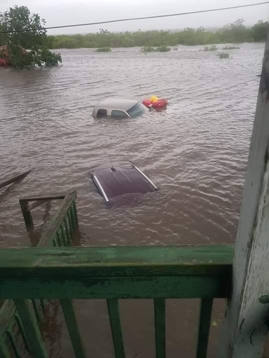
And at this point, we don’t have to wonder if there will be “catastrophic flooding” in New Orleans, because some parts of the city are already under “3 to 4 feet of water” thanks to all of the rain that has already fallen…

After Wednesday’s onslaught of heavy rain, Valerie Burton said her neighborhood looked like a lake outside her door.

There was about 3 to 4 feet of water in the street, pouring onto the sidewalks and at my door,” Burton said. “I went to my neighbors to alert them and tell them to move their cars.”

Over the next few days things will get a lot worse for New Orleans.

The only question is how much worse.

And guess what?  Once the storm leaves southern Louisiana, it is expected to head north directly through the heartland of America.


Yes, the exact same area that has been relentlessly pounded by storm after storm for months.  We were already potentially facing widespread crop failures all across the middle portion of the country, and this massive storm is going to make things much worse.

According to the NOAA, the 12 months ending in June were the wettest 12 months in all of U.S. history…
Rain – and plenty of it – was the big weather story in June, adding to a record-breaking 12 months of precipitation for the contiguous U.S. It’s the third consecutive time in 2019 (April, May and June) the past 12-month precipitation record has hit an all-time high.

And now here in July an absolutely monstrous storm is going to rip through the middle of the country at the worst possible time.


The scenarios that I have been warning about are starting to develop right in front of our eyes, and many Americans are becoming extremely concerned about what the months ahead will bring.

It seems like every week we are talking about another unprecedented disaster.  America is being hammered over and over again, and this latest blow to New Orleans looks like it could be extremely severe.

Let us hope that this storm does not turn out to be as bad as the meteorologists are now projecting, because it appears that many Americans are about to have their lives completely turned upside down.


... ALREADY BEGUN!

The storm surge from this Tropical Storm has just started hitting the mouth of the Mississippi within the past hour.  Here is the actual storm surge water gauge reading:
Prudence dictates you take action NOW to protect yourself and your family.   I recommend you stop what you're doing, pack your valuables, family photos, some clothing, some food and insurance policies, get in your car and GET OUT NOW.
Don't wait.  Because by the time the government tells you to leave, it may very well be too late for you.

BULLETIN
FLASH UPDATE 11:45 AM EDT --
New Orleans Mayor LaToya Cantrell warned that 48 hours of heavy rainfall could overwhelm the pumps the city uses to fight floodwater, leading to flooding.
"We cannot pump our way out of the water levels that are expected to hit the city of New Orleans," Cantrell said. "We need you to understand this."
Water pumps already were working at capacity after heavy rains, she said.

----- Hal Turner Remark -----   Now?    Now she says this????   It's been clear for days.   Folks in and around New Orleans are URGED (by me) to EVACUATE RIGHT NOW.  

UPDATE 12:07 PM EDT --
This "Tropical Storm" is rapidly becoming a Hurricane.  Look at this satellite infrared image:

Barry Intensifying & Earthquake Report with Margo (July 12, 2019)