Global
warming in real time. The latest is that it is, indeed raining 'cats and dogs' at the North Pole and ice thickness is less than a meter - surrounding areas have greater ice thickness than the Pole. In addition there are high levels of methane release.
North
Pole Web Camera 2 Adrift in Large, Expanding Melt Pool
18
July, 2013
(Image
source: APL)
Last
week, a melt puddle began to form near APL’s Camera 2. The pool
extended in the near camera field from left to right just beyond the
black and white markers. It covered just more than half the field of
view and was represented by a thin, though growing, swath of melt
water.
As
you can see in the image above, last week’s melt pool has greatly
increased. It now covers the entire camera field and has turned the
ice on which the camera stands into a tiny island. In the distance
and to the left-hand side, we can also see a black stretch of open
water cutting between the ice flow upon which the camera sits and a
far ice flow barely visible in the distance.
Hole
at the North Pole
Since
early June, a series of storms have consistently worn away at the
central ice, resulting in thinning over an area that is usually very
resilient to melt. This thinning has resulted in steep losses of sea
ice concentration and thickness in a large swath near the North Pole
and extending into the Laptev Sea.
The
US Navy’s most recent thickness model run shows this expanding
swath of thin ice in the animation below:
In
the most recent model prediction, central sea ice melt is shown to
continue to expand through next week. So, through direct observations
on the ice and through model summaries like the one above, we have
clear evidence of expanding ice melt in the Arctic’s most protected
regions. As such, it seems North Pole Camera 2 may soon be in even
deeper water.
Links:
High methane readings over Kara Sea
18 July, 2013
Arctic sea ice extent 2013 (brown line on NSIDC-image below) is more and more following the same path it did last year (dashed line), when extent reached a record minimum, and in 2007 (blue line), the previous record minimum.
Even more worryingly, sea ice is very thin, as the Naval Research Laboratory animation below shows; large areas with a thickness of 1 meter to zero persist close to the North Pole, as discussed in an earlier post; the animation further shows the retreat of sea ice from the Kara Sea, north of Siberia, over the past 30 days.
As can be expected, high sea surface temperature anomalies show up in areas where the sea ice has retreated, as shown by the DMI image below.
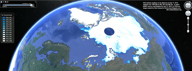
Most worryingly, high methane readings appear over the Kara Sea, as shown on the image below.


No comments:
Post a Comment
Note: only a member of this blog may post a comment.