Australia extreme heatwave: 'code red' issued as Port Augusta hits 48.9C
Severe weather conditions forecast to bring maximum temperatures 8C to 16C above average, as three towns record overnight minimums of 33C
Australia’s extreme heatwave enters third day as temperatures soar
15 January, 2019
Port Augusta in South Australia has reached 48.9C on Tuesday, as a heatwave sets in across much of Australia threatening more record hot days.
All-time highest minimum temperatures have also been broken in three places. Meekatharra in Western Australia and Fowlers Gap and White Cliffs in New South Wales all registered an overnight minimum of 33C on Monday.
Severe to extreme heatwave conditions extending from the interior of WA across South Australia, Tasmania, Victoria, the ACT and NSW will bring maximum temperatures of 8C to 12C above average, and in some places up to 16C above average before the end of the week.
From Tuesday through to Friday, parts of South Australia, Victoria and NSW may break January heat records, with daytime maximums extending up to the mid-40s.
“It’s quite a significant heatwave because we are expecting a number of records to fall across those areas for both minimum and maximum temperatures,” said Dean Sgarbossa, a senior meteorologist with the Bureau of Meteorology.
On Tuesday, Port Augusta in South Australia reached 48.9C, an all-time high since records began in 1962.
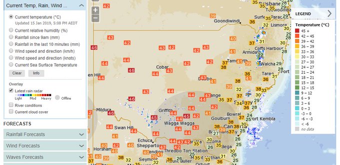
Port Augusta Hay in NSW had reached a high of 47.2C by Tuesday afternoon and several locations in Victoria reached temperatures in the mid-40s, with Walpeup in the state’s north-west recording 45.6C.
South Australia is forecast to have three days of severe to extreme heat.
The South Australian housing authority has issued a “code red” until 16 January for greater metropolitan Adelaide.
A code red means homelessness agencies will increase their services during the hot weather, including extending their operating hours.
The Telecross REDi service, a Red Cross service that supports vulnerable people by calling them daily during heatwaves, has also been activated until Thursday. About 750 South Australians are on the list to receive calls during that time.
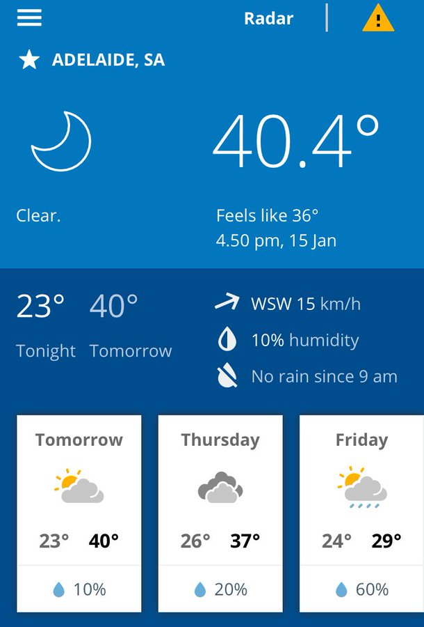
In Adelaide, where the heat is affecting cycling’s Tour Down Under, temperatures reached 41C on Tuesday and are forecast to hit 40C on Wednesday.
In Victoria, severe to extreme heatwave conditions were forecast through to Friday and several locations across the state’s north were expected to reach or exceed maximum January temperature records.
Rutherglen, Yarrawonga, Echuca, Shepparton and Mildura were all expected to reach 46C on Tuesday and Mildura’s temperature was 45.8C by the afternoon.
Since midnight on Monday there were 20 active scrub, grass and bushfires in the state and authorities again had to issue warnings about the “disturbing trend” of people breaking total fire bans and lighting camp fires.
On Tuesday afternoon, seven aircraft and more than 20 trucks were at an out of control grass and scrub fire at Benloch, north east of Macedon that was threatening property.
The nearest property was about 500m from the fire front and Emergency Management Victoria issued an emergency warning for residents to shelter in their homes.
“For those people and people in that area, I want to reassure you that we’re doing everything possible in relation to the fire,” the state’s emergency management commissioner Andrew Crisp said.
In Melbourne, where the Australian Open is under way, coastal breezes are keeping the heat to the low and mid-30s, after reaching 37C on Monday. However, the city’s outer suburbs will see temperatures into the 40s over the next couple of days.
The ACT is expecting three days in a row of maximum temperatures above 40C from Wednesday, and NSW will bear the brunt of the heatwave later in the week when a large area of extreme heat conditions hits densely populated areas.
“The entirety of the state of NSW will experience severe heatwave conditions for the majority of this week,” Sgarbossa said.
Several areas across western NSW are expecting temperatures above 45C from Tuesday and all the way through to the weekend.
The Bom said that while the heat in coastal areas in the east of the state was tempered by sea breezes, high humidity would make the days ahead feel hotter than the temperature suggested.
Sydney was forecast to reach 30C on Tuesday, 32C on Wednesday and 34C by Friday, before a cool change.
But some western suburbs would exceed 40C for much of the week.
“What’s going to be unique about NSW is overnight temperatures will be unusually warm across large areas of inland NSW, with some locations in the far west staying above 30C,” Sgarbossa said.
Much of the country had elevated fire danger ratings on Tuesday and that is expected to continue through the week.
The Bom is forecasting a cooler change to start moving across through much of the heatwave-affected area from Friday.
World’s hottest places all located in Australia amid intense heatwave
16 January, 2019
The top 15 hottest places in the world yesterday were all in Australia, as an intense heatwave weather system - possibly the worst since 2011 - continues to sweep over the country.
Of the 15 locations, 10 were in South Australia, three in New South Wales and another two in the Northern Territory, with temperatures ranging between 46.1C and 49.1C, according to US-based El Dorado Weather.
The record-breaking burst of hot summer weather over the last four days are among the 10 hottest on record, according to Weatherzone.
Matters are made worse in Sydney, where there is a health warning in place with high levels of ozone expected due to poor air quality.
Ozone at ground level can irritate human eyes and airways and damage plants. Breathing ozone can affect lung function and worsen asthma.
"Definitely staying cool over the next few days right across the state is the advice," NSW Deputy Commissioner Jeff Loy said.
"There is also a warning today for poor air quality across Sydney. So anyone who has breathing issues, asthma, they are being reminded to keep their medication nearby and close the windows if at all possible
"It is going to be a very, very warm week.”
Severe storms are also on the way in the next few days in South Australia, Victoria and western and central NSW due to a broad trough and hot unstable airmass.
RECORD-BREAKING HEAT
The Bureau of Meteorology forecast daytime temperatures up to 12C above average and 10C higher than usual at night from Monday to Friday.
All states and territories except Tasmania have centres where the temperature is due to stretch into the 40s.
At Port Augusta, Tuesday's maximum was the highest since records began in 1962 with 47C forecast for Wednesday and Thursday ahead of a milder Friday.
The small town of Tarcoola in central South Australia hit an eye-watering 49C on Tuesday.
"They are pretty incredible temperatures," senior forecaster Michael Efron said.
People in Adelaide didn't escape, with the SA capital reaching 41.2C.
Several towns along the NSW-Victoria border felt the hot weather, with Mildura hitting 46C.
In central NSW Ivanhoe got to 46.8C, while a sea breeze limited inner Sydney to 29C but the western suburbs, including Penrith, recorded 39.7C.
Australian Open players had cooler conditions than on Monday as Melbourne reached a bearable 30.4C, while outer suburbs like Scoresby hit 40.2C.
A total fire ban is in place across Victoria due to the risky conditions.
By late afternoon fire and parks services were monitoring 25 blazes including one on the east coast's Freycinet peninsula and another at Bothwell, with 17 burning.
Lightning strikes have sparked bushfires across Tasmania with firefighters battling up to 25 separate blazes in addition to a challenging fortnight-long wilderness blaze.
Hot and windy weather combined with 1200 dry lightning strikes to spark the blazes across the state, the Tasmania Fire Service said.
By late afternoon fire and parks services were monitoring 25 blazes including one on the east coast's Freycinet peninsula
"We have been able to hit them hard and fast before they become a problem."
Northwest of Hobart, the Gell River fire, which has burnt through more than 20,000 hectares, continues to challenge firefighters.
"We don't have any edge of the fire that we can drive to," Tasmania Fire Service controller Peter Dobson said.
FIRE WARNINGS ISSUED AND RESIDENTS ON ALERT
People in multiple states have also been warned of a potentially dangerous fire risk amid the hot weather.
In South Australia, Total Fire Bans have been implemented in the West Coast, Eastern Eyre Peninsula, Flinders, Mid North, Yorke Peninsula and Mount Lofty Ranges regions which are all facing a "Severe" risk.
An 'Advice' level warning remains for residents in Nairne, where a fire has been burning near Sydney Road despite reducing in size.
In Victoria, Total Fire Bans are yet to have been put in place, however the Northern Country and North East regions are both facing "Severe" danger ratings.
Meanwhile, in New South Wales 10 different regions stretching from the Queensland border down to the Victorian border all face a "Very High" level of fire risk.
Three Total Fire Bans are currently in place for the North Western, Central Ranges and Southern Slopes regions. The bans will be increased tomorrow to include three additional regions.
TEMPERATURES AROUND AUSTRALIA TODAY
Sydney – min 22, max 41
Melbourne – min 19, max 34
Brisbane – min 21, max 38
Perth – min 17, max 30
Adelaide – min 23, max 41
Hobart – min 15, max 26
Canberra – min 20, max 41
Darwin – min 25, max 35
Record-breaking conditions as extreme heatwave hits Australia
/arc-anglerfish-syd-prod-nzme.s3.amazonaws.com/public/HZ4U35YZSFBNZFX5ACKVBW63AM.png)
16 January, 2019
Forecasters have cautioned that there is "no reprieve" from the heatwave until at least the weekend as already record-breaking temperatures reach their peak.
Parts of Sydney will swelter into the 40s on Wednesday, just a precursor of a 45C high to come on Friday. Canberra could reach 41C today while 45C is likely in regional cities across New South Wales. On Tuesday, Hay, in the west of the state, almost touched 48C.
An extreme heatwave that poses a risk to even fit and healthy people is now in full swing in eastern parts of the state. The Bureau of Meteorology (BOM) has warned of "oppressive conditions".
Yes, it's summer and heat is no stranger this time of year — but this is something else.
The NSW Health Department has said it's now the worst heat the state has experienced for a prolonged period since 2011, when a heatwave increased the mortality rate by 13 per cent and hospital admissions by 14 per cent.
Adelaide could peak at 40C today, but Melbourne and Tasmania will see some relief form the roasting conditions aided by sea breezes.
But you don't have to go far inland to see the mercury rise. Bendigo, Victoria could top out at 43C today.
Perth is fine and summery today but come the weekend it too will touch 40C.
BOM meteorologist Diana Eadie said much of the country remained stuck in heatwave mode.
"Temperatures are expected to climb into the low to high 40s — that's eight to 12 degrees above average.
"We've already seen some January maximum temperature records fall and we're likely to see many more before this event is over," she said.
"The humidity will lead to really oppressive conditions."
Authorities across the southeast have urged people to hydrate, check on vulnerable friends, family and neighbours and not to leave children or pets in hot cars.
In South Australia, the government has declared a Code Red heat emergency for Wednesday.
This triggers extra funding so services for the homeless can be extended while a special phone line will also operate providing regular checks on the elderly and others at risk from the extreme conditions.
WHY IT'S LASTING SO LONG
Sky News Weather channel meteorologist Rob Sharpe explained why this heatwave had been so intense.
"High pressure is sitting over the Tasman Sea. High pressure spins anticlockwise so that's guiding heat from northern and central Australia into southeastern Australia."
But with nothing to shake that system up for the next few days, the heat has just kept on building.
On Tuesday, the BOM remarked: "The heat will build up through this week and people are warned they should not expect a reprieve until at least the weekend in many areas."
AROUND THE MAJOR CENTRES
Looking around the areas most affected, Sydney will see 31C on Wednesday rising to 34C on Friday. But in Penrith, in the west, that rise is from 41C to 45C, up to 11 degrees more sweltering.
Across the city, night time lows will be a sweaty 22C.
In Canberra, the mercury will likely pass the 40C mark every day until Friday with night time lows of 20C. Albury will see four consecutive days above 40C with Wednesday on 45C.
Adelaide is on 40C today and then 37C on Thursday.
The weather at the Open in Melbourne is relatively mild — 26C and then 33C on Thursday. Nights are still hot though at around 22C.
Hobart will see 23C today rising to 26C on Thursday.
In Queensland, Brisbane will continue on a run of sunny days and 33C.
Perth will get to 29C today, then 32C on Friday and a scorching 40C on Sunday. It will be 34C and possible storms in Darwin.
COLD CHANGE DUE … EVENTUALLY
An end to the huge highs is in sight which will bring blessed relief.
"The heat is remaining stagnant through the southeast until we have this cool change on Friday and Saturday," Ms Eadie said.
That trough should pass through Adelaide on Friday, Melbourne late the same day and Canberra and Sydney on Saturday.
That should shave five to eight degrees off temperatures — far more in western Sydney and regional cities. Penrith will go from 45C on Friday to 29C on Sunday.
However, the cold front brings its own risks, she said.
"Dry thunderstorms are a particular concern as lightning with no rain may ignite new fires."
All that wind may bring the mercury down but, it can also stoke those flames. As such Friday and Saturday will be peak fire danger times.


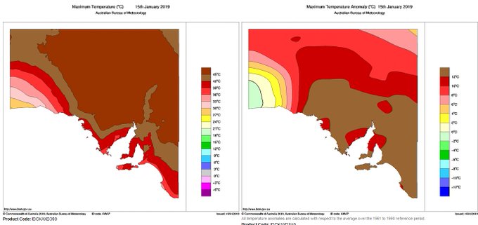
 On the left we can see SA's observed max temperatures for 15 Jan 2019, on the right we can see it was generally 10-14°C hotter than average. What a stinker!


 . Mercury is hovering around 40°C in the shade in Adelaide, so stay hydrated and keep cool at the

No comments:
Post a Comment
Note: only a member of this blog may post a comment.