

A
Pair of Monster Cyclones Have Exploded to Life in the Pacific
1
August,, 2018
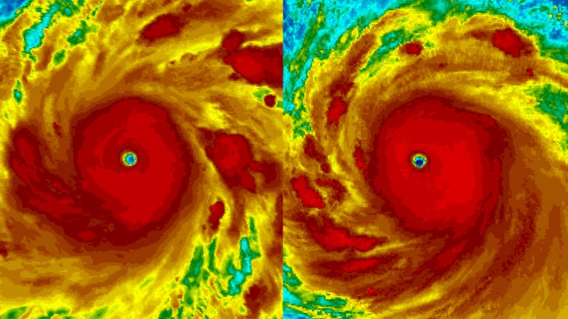
Take
a look at that image up there. It’s the planetary version of ಠ_ಠ.
Earth, it appears, is sick of our shit and it’s sent the message
via two monstrous cyclones in the Pacific.
Hurricane
Walaka and Super Typhoon Kong-rey are out there staring down
satellites, and by extension, their human creators. The storms
underwent a dramatic transformation Sunday night into Monday and are
now the two strongest storms on the face of the Earth.
Both
underwent rapid intensification, a meteorological process where
cyclones’—the generic name for hurricanes and typhoons—wind
speeds crank up at least 35 mph over a 24-hour stretch.
Walaka, situated
in the Central Pacific,
was officially a Category 4 storm with winds of 150 mph as of 11 a.m.
Hawaii Standard Time, though meteorologist
Ryan Maue estimated that
based on satellite observations, it was likely much stronger by
mid-morning local time.
Meanwhile
Kong-rey, churning in the Western Pacific about 200 miles southeast
of Taipei, was
packing sustained winds upwards of 155 mph, the equivalent of a
strong Category 4 hurricane. It could menace Japan late this week,
continuing a string of rotten weather luck that’s plagued the
country all year.
Jeff
Masters, a meteorologist at Weather Underground, told Earther that
the official forecast was likely underestimating Kong-rey as well. In
both cases, that’s due to something forecasters use when looking at
satellite images known as the Dvorak constraint. Basically if a storm
looks like it’s intensifying too fast, they assume satellite error
is responsible.
Assuming
the storms continue to strengthen and officially obtain Category 5
status, they would become the first pair of Category 5 storms ever
recorded at the same time in the Pacific, according to Masters.
“We
came within 6 hours of this happening in 2009, though,” he told
Earther. Then, Super Typhoon Lupit became a Category 5 in the Western
Pacific just six hours after Hurricane Rick weakened slightly. Alas!
The
freaky sight is likely due to a burbling El Niño, which tends to
warm the waters in the Pacific and calm down winds that can slow down
hurricanes, particularly in the central and eastern parts of the
ocean. Indeed, the eastern half of the Pacific has been going off.
One measure of that is accumulated cyclone energy (ACE), which takes
into account wind speeds of every cyclone for every hour of its life,
providing a better metric for how serious a hurricane season was
rather than just listing the number of storms. What was a slightly
above average season for the Eastern Pacific took off like a rocket
in August and the storm parade hasn’t stopped since then. ACE is
more than double the average for this time of year. The western
Pacific is outpacing its average for this time of year as well, with
ACE running about 30 percent above normal according to data
maintained by Colorado State University.
Climate
change is also heating up the oceans around the world, providing more
warm water to fuel cyclones. A study out last week looked at the
influence of climate change and natural factors on the 2017 Atlantic
hurricane season (short answer: climate
change played a role)
and the researchers plan to do a similar analysis for 2018 in the
Pacific. Which seems like a good idea.
Powerful
gales and torrential downpours could lash the UK if Leslie, currently
whipping up near hurricane-force winds off the coast of Bermuda, hits
at the end of next week.
Forecasters
are watching the path and development of the storm amid fears it will
strengthen into a full-blown hurricane through the coming days.
It
shows signs of sweeping northeastwards towards the UK although
experts are unsure whether it will make a direct hit or swerve
southwards and hit the Continent.
Met
Office chief forecaster Andy Page said: “Tropical Storm Leslie is
currently in the central North Atlantic and is expected to remain
there over the next few days.
“Leslie
will likely strengthen to a hurricane as it moves over warmer waters
on Tuesday and Wednesday, with large swells affecting Bermuda and
east coast of US and Caribbean.
“It
is likely to gradually weaken after this and to move eastwards across
the north Atlantic.
“Some
models suggest Leslie will track south of the UK while others suggest
it may move close to the UK by the end of next week.

This is a remarkable (crazy) pattern unfolding across Alaska and into the #Arctic. Late summer-like warmth will spread across the region in association with an anomalous blocking upper level ridge.
00:12 Tunisia: Nabeul flash floods
05:56 Mexico: Periban & Cabo San Lucas flash floods
12:19 Greece & Turkey: Medicane Zorbas
19:31 Japan: Typhoon Trami
22:50 India: Himachal Pradesh floods
24:37 Venezuela: Vargas flash flood
26:19 Canada: Gatineau tornado
29:27 The USA: Texas, Tennessee & Tristate storms
30:48 Temperature Data
Arctic heatwave could result in summer-like warmth for Alaska

29
September, 2018
A
high-pressured western ridge has positioned itself near Alaska,
allowing record-breaking warmth from the North Pacific to spread over
the Arctic.
A
ridge, in weather terms, is defined as an elongated area of
relatively high pressure extending from the center of a high-pressure
region.
Climate
scientist Zack Labe told Euronews this phenomenon could cause
temperatures to rise over 10°C above average in some areas of
Alaska, making the climate feel equivalent to late-summer. Labe
believes this pattern will likely slow the progression of sea ice
refreezing in the western Arctic.
"The
remnants of Typhoon Trami (which is currently battering southern
Japan) along with the unusually warm sea surface temperatures in the
North Pacific and the Bering Sea, are likely to contribute to the
strength and persistence of this weather pattern," says Labe.
Zack Labe
✔
@ZLabe


This is a remarkable (crazy) pattern unfolding across Alaska and into the #Arctic. Late summer-like warmth will spread across the region in association with an anomalous blocking upper level ridge.
This is a remarkable (crazy) pattern unfolding across Alaska and into the #Arctic. Late summer-like warmth will spread across the region in association with an anomalous blocking upper level ridge.
These
recent weather transformations are also impacting maritime transit.
Earlier this month, the Danish cargo ship Venta Maersk, became the
first ship to navigate the Northern Sea Route, which runs from Alaska
along the Siberian coastline and was thought previously to be
unpassable.
Due
to warming ocean temperatures, sea ice has diminished to the point
where it could be possible for global shipping to use this shortcut
between the months of July to October.
Experts
say the Northern Sea Route could cut transit time by 10-15 days by
reducing the travel distance from east Asia to Europe from the 21,000
kilometres, via the Suez Canal, to 12,800 kilometres.
Last
weekend, the Climate Prediction Center (CPC) predicted significantly
warmer temperatures for northwestern Alaska during October backed by
85% confidence.
According
to Rick Thoman, climate science and services manager for the National
Weather Service in Alaska, it's the first time in recorded history
that the CPC has issued a probability forecast above 80%.
Friday,
September 28, was another record-breaking temperature day in
Anchorage, Alaska, where it hit a record 16°C in the city. Other
Alaskan towns of Bethel and King Salmon also saw record high
temperatures Friday according to the National Weather Service
Anchorage.
Conversely,
a conduit for colder temperature anomalies has developed off the
eastern side of the high-pressure ridge, effectively pushing seasonal
air further south. This has caused parts of Canada to experience
unprecedented amounts of September snowfall. Canada's western
province of Alberta is expecting upwards of 20cm of snow in the
coming days.
Climate & Extreme Weather News #138 (21st to 30th September 2018)
00:12 Tunisia: Nabeul flash floods
05:56 Mexico: Periban & Cabo San Lucas flash floods
12:19 Greece & Turkey: Medicane Zorbas
19:31 Japan: Typhoon Trami
22:50 India: Himachal Pradesh floods
24:37 Venezuela: Vargas flash flood
26:19 Canada: Gatineau tornado
29:27 The USA: Texas, Tennessee & Tristate storms
30:48 Temperature Data
And
in America...
No comments:
Post a Comment
Note: only a member of this blog may post a comment.