Why Did The Catastrophic Camp Fire Start Where It Did?
Death-toll 42 and rising: California's deadliest wildfire still has many more people said to be unaccounted for: Thousands buildings at risk
Photo
NBC News
12
November, 2018
Thirteen
more bodies have been recovered in California, bringing the death
toll in the US state's deadliest wildfire to 42, officials say.
The remains were found in and around the largely incinerated town of Paradise, in the north of the state.
At least 228 people are missing as the Camp Fire continues to rage.
Nearly 7,200 structures have been destroyed, and another 15,500 are at risk.
The fire has now surpassed the 1933 Griffith Park disaster that killed 31.
Speaking at a news conference on Monday evening, Butte County Sheriff Kory Honea confirmed the number of dead and the official number of missing.
Many more people are said to be unaccounted for.
In the south of the state, other wildfires are menacing lives and property.
The Woolsey Fire has so far killed two people as it damaged beach resorts, including Malibu.
More than 300,000 locals have been forced to flee their homes across California.
President Trump has declared a "major disaster" in the state, making federal aid available to affected residents.
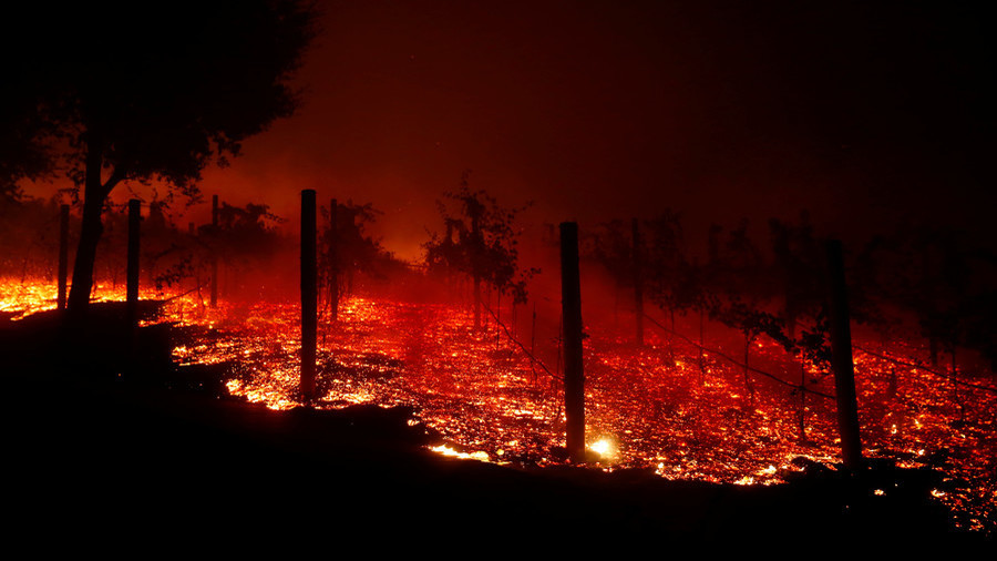
Paradise and its surrounding areas bore the brunt of the Camp Fire - the largest blaze - which started in the nearby forest on Thursday.
Some bodies were found in gutted cars that were overrun by the fast-moving fire, as residents scrambled to evacuate overnight.
Sorrell Bobrink, a Paradise resident who managed to drive away with her child, told BBC World Service radio she was first woken up and alerted by a phone call from a friend.
She described the scene as "exactly like any apocalyptic movie I have ever seen" and said she did not know if she was driving towards death or out of harm's way as the sky blackened.
"I had to drive through the fire - it was awful.
It was probably the most awful experience I will have in my life," she told the Newsday programme. "It was traumatizing, we will be traumatized for a long time.
My whole community was traumatized - I can't watch the videos anymore because I actually went through it."
Many of the victims are believed to be elderly residents or people with mobility issues who would find evacuating more difficult.
Forensic experts are stepping up their search in the ruins of Paradise, but officials warn that finding the bodies could take weeks.
Cadaver dogs are being brought in by local police to try and locate the dead, and two mobile army morgues will be used to help identify them.
The fire has burned more than 111,000 acres (45,000 hectares) and is nearly 25% contained, fire officials said.
The separate Woosley Blaze started on Thursday near Thousand Oaks, about 40 miles (64km) north-west of central Los Angeles.
It has consumed at least 85,500 acres and destroyed at least 177 buildings, officials said. It is only 10% contained.
The smaller Hill Fire, nearby, has scorched 4,530 acres and is 75% contained.
'Want to live in a war zone?' California homeowners face ruin after wildfires

13
November, 2018
PARADISE,
Calif. – Thousands of wildfire-weary Californians face financially
and emotionally difficult years ahead as they begin rebuilding their
homes and communities destroyed by the rampaging flames.
In
Northern California where the Camp Fire still burns, 6,543 homes have
been destroyed, along with hundreds of businesses. Near Malibu, the
Woolsey Fire has destroyed about 370 structures.
Most
evacuees have no idea how their homes fared because evacuation orders
keep the public from the dangerous conditions caused by the Camp and
Woolsey fires. Though a few people know – including actor Gerard
Butler and singer Robin Thicke – most evacuees are stuck waiting
for information, begging reporters for updates and trying to finagle
their way past road closures.
Matt
McNeill, 53, knows his house is gone. It burned down in Paradise as
he desperately fled in his car, scooping up neighbors on the way. He
has homeowner’s insurance but isn't sure he'll rebuild.
A
general contractor, McNeill has been building homes in Paradise since
1990. He faces the thought of returning to a community vastly
different from the one he fled.
The
commercial district lies in ruins, dozens of business and municipal
facilities destroyed by the fire. Thousands of burned trees will have
to be cut down for safety, changing how Paradise looks for years to
come.
"Would
you want to live in a war zone for a decade or more?" McNeill
said by text. "But then, our kids grew up there – great, great
memories, beautiful people. Not really sure where life is headed now.
Have to really think about that one."
Authorities
have not begun notifying McNeill's neighbors about how their homes
fared, in part because firefighters are trying to control the
Paradise and Woolsey fires. Sending in ground-based survey teams
remains too dangerous.
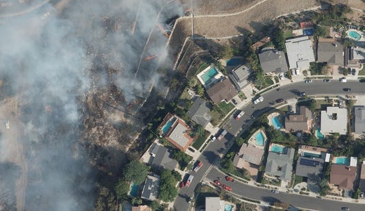
From
thousands of feet in the sky, specialists working for the nation's
insurance companies take photos that building inspectors, assessors
and firefighters can use to help inform the public.
“Underneath
that smoke are people’s lives that have come unraveled," said
Jim Schweitzer, senior vice president and chief operating officer of
the National Insurance Crime Bureau.
The
bureau works with insurance companies across the country to fight
insurance-related fraud and crime, including vehicle thefts, but also
to combat disaster-related fraud. In some cases, unscrupulous
contractors perform shoddy work or conspire to get insurance
companies to pay for extra work not caused by a disaster, which can
bring felony charges and void a homeowner's coverage.
The
stakes are high in the fires, which threaten nearly 50,000 homes
valued at about $18 billion, according to property data company
CoreLogic. The value of the destroyed homes has not been compiled
because authorities don’t have a complete assessment of the damage.
The
insurance bureau partnered with imaging company Vexcel Imaging to
create the Geospatial Intelligence Center, a not-for-profit
initiative of the bureau funded by a consortium of insurers.
Technicians take high-resolution aerial imagery of disaster areas
with $1.5 million Vexcel cameras shooting out the bottom of
airplanes.
A
little more than a year old, the GIC's Colorado-based teams have
deployed to numerous natural disasters across the country, most
recently to the East Coast to image the damage left by Hurricanes
Michael and Florence. They fly over the Paradise and Woolsey fires.
The
GIC mission includes mapping virtually every home and building in the
country, providing insurers with "before" photos to compare
with post-disaster imagery.
The
searchable database of photos is initially available only to first
responders, recovery agencies and member insurers but will be made
public shortly.
“Like
it or not, it’s a confirmation. That alone can go a long way to
beginning the recovery process,” Schweitzer said. “The
uncertainty is gone, and you can move forward.”
In
addition to helping insurers fight fraud, the photos allow them to
reach out directly to their policyholders to help them with temporary
housing and living expenses even before victims have a chance to
check on their homes in person, Schweitzer said.
For
many people who lost their homes, the journey to recovery is just
beginning. McNeill said he has been overwhelmed by the generosity of
strangers, who gave his family clothes and even a bike for his
grandson. His family is adjusting to the loss, he said: "You
think, 'I don't have that anymore.' (But it's) the little things that
get you through. Gonna smile our way through it."
For
others, the routine of work provides some level of normality, even
amid the devastation. Butte County sheriff's Deputy Brian Evans, 42,
is still on the job even though his house burned down before he could
grab anything from it. Wearing his uniform, which is pretty much the
only clothing he owns, Evans spent the weekend helping search for
missing neighbors and friends.
Rebuilding
Paradise won't be easy, he said as smoke rose from the ruins. His
son's school burned down, their neighbors all lost their houses, and
dozens of the people he served died in the fire.
Disasters
such as the Paradise and Woolsey fires inevitably change the face of
a community for decades. Some evacuees will never return. Some
homeowners will choose to rebuild elsewhere. Small businesses may go
under, and employment may be hard to come by for the thousands of
people whose cars were destroyed. Evans said he's committed to seeing
it through. This is his home, after all.
"It
will take a while," he said. "But it will get better. It
always does."
California wildfire rips through nuclear waste site, fueling airborne toxin risk concerns

RT,
13
November, 2018
The
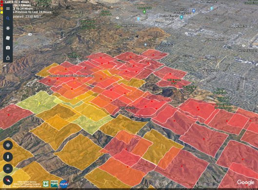
Woolsey fire that engulfed over 90,000 acres in California last
weekend may have spread toxic and radioactive substances from a
Superfund site, according to activists who believe authorities might
be downplaying the risks.
The
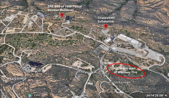
fire passed through the Santa Susana Field Lab (SSFL), a federal
Superfund site in the Simi Hills that was the site of the worst
nuclear meltdown in US history in 1959. While the California
Department of Toxic Substances Control said there was no reason to be
concerned of "any
risks other than those normally present in a wildfire situation,"
locals aren't so sure, pointing out that the agency has dragged its
feet in cleaning up toxic sites and accusing it of a possible
cover-up.
Physicians
for Social Responsibility Los Angeles president Robert Dodge
castigated the DTSC, pointing out
that the site – now owned by Boeing – remains radioactive and
polluted despite the agency's promise to clean it up eight years ago.
"These
toxic materials are in SSFL's soil and vegetation, and when it burns
and becomes airborne in smoke and ash, there is real possibility of
heightened exposure for area residents."
The
DTSC reassured residents
that the SSFL facilities were not affected by the fire and claimed
measurements of radiation and hazardous compounds from both the site
and the surrounding communities were within normal levels, posing
no danger other than that normally present in the aftermath of a
wildfire. Thousands of people live within two miles of the site,
which was originally developed to test rocket engines and conduct
nuclear research in the 1940s.
NASA,
which owns a small piece of the site, echoed the DTSC's message
in a press release, stating that the fire presented no risks beyond
those normally associated with wildfires although its property
experienced "significant
fire damage"
across all three "historic
districts."
Residents'
concerns about authorities possibly downplaying the risks are fueled
by the DTSC's track record of broken promises, combined with the very
real history of nuclear meltdown onsite. The California state
legislature commissioned an Independent Review Panel to investigate
the DTSC and found in
2016 that the agency had placed communities "at
risk" by "failing
to perform its basic function of protecting the public and
environment from industrial hazardous waste and contamination."
The DTSC was held responsible for the Exide scandal in Vernon, in
which a battery recycling plant leaked toxins into surrounding
communities for decades, and was criticized for its backlog of
hazardous waste permits.
Local
parents have blamed contamination at the SSFL site for their
children's cancers, and the Centers for Disease Control designated
lab workers from the 1950s who developed cancer as part of a "special
exposure cohort"
eligible for compensation for their years of laboring in a
radioactive environment. While the SSFL was the site of multiple
nuclear accidents, the worst took place in 1959 when a reactor vented
nuclear material to avoid an explosion, ultimately releasing 459
times more radiation than the infamous Three Mile Island meltdown 20
years later.


 THREAD
  Spread the word.


No comments:
Post a Comment
Note: only a member of this blog may post a comment.