Ireland doesn’t exist (or doesn’t matter) for the Express.
Hurricane Ophelia upgraded to Category 3: Storm strengthens as UK braces for BATTERING
HURRICANE Ophelia has been upgraded to an almost unprecedented Category 3 storm as it slowly makes its way towards the UK mainland.
Ophelia has become the sixth major hurricane of the 2017 season after it was upgraded to a Category 3 storm.
Storms of this strength are extremely rare and Ophelia's current location is the farthest east a major Atlantic hurricane has ever been seen.
If the storm were to hit Britain at its current strength, it would be among the most powerful weather systems ever to hit the UK mainland.
While Ophelia is expected to slow down by the time it hits the UK, the Met Office has issued severe weather alerts and warned there could be potential power cuts, disruption to road and rail networks, and damage to buildings.
Western England, Northern Ireland and parts of Scotland will be most affected by the storm winds, with coastal areas expected to face the brunt of the weather conditions....
This report is 15 hours old. The hurricane has been upgraded since then.
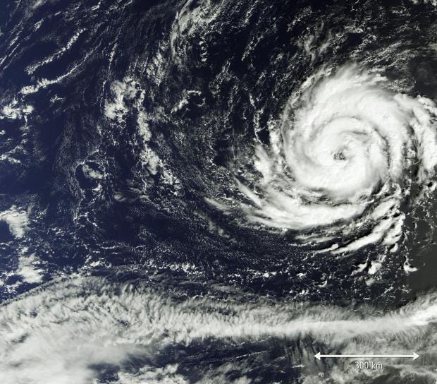
Ireland
is bracing itself for what could be the worst storm since 1961,
according to Met Éireann, the country’s national meteorological
service.
Hurricane
Ophelia, which is currently south-west of the Azores islands near
Portugal, 2,500km away from Ireland, is expected to hit the country’s
west coast on Monday.
By
this time, it will have lost its hurricane status but will still be a
powerful storm. Areas including Cork, Kerry, Clare and Galway &
Mayo are set to see wind speeds in excess of 130kmh (80mph).
The
Irish meteorological service has issued its highest possible "status
red" warning ahead of the arrival of Ophelia.
It
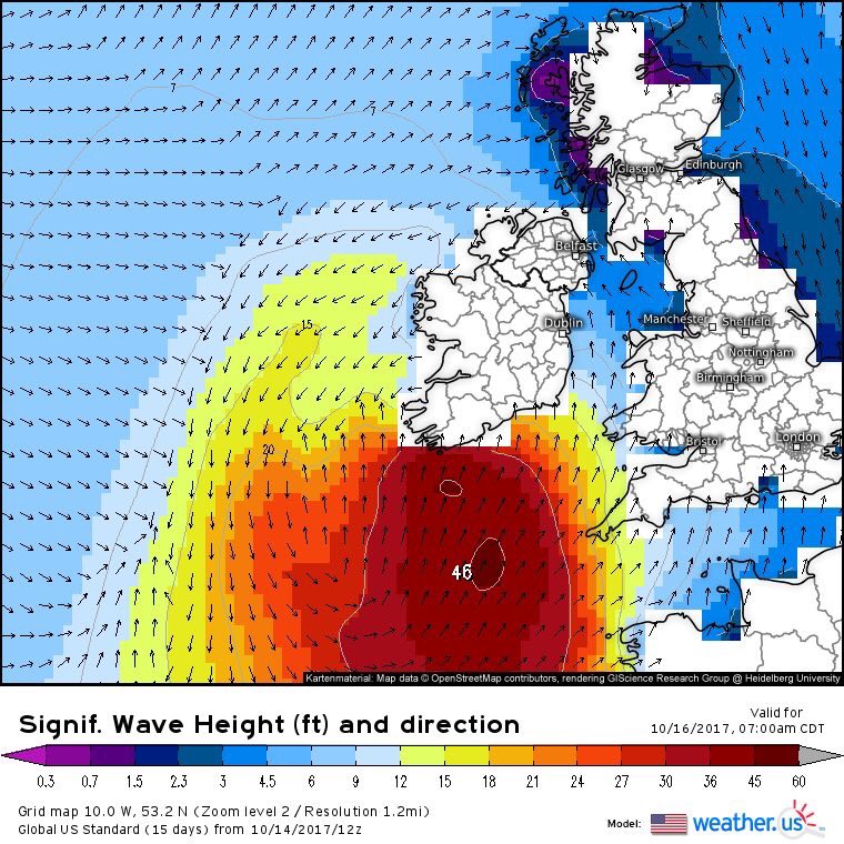
is feared large waves may lead to flooding in coastal areas.
The
tropical storm is currently making its way across the Atlantic as a
category 1 hurricane with winds of up to 100mph.
A
Met Éireann spokesperson told The Independent the storm could cause
as much damage as Hurricane Debbie, a 1961 storm which killed 16
people in the Republic of Ireland and two people in Northern Ireland.
“The
tail end of hurricanes often affect Britain and Ireland, but usually,
by the time they reach us they will have lost most of their power,”
the spokesperson said.
“We’ve
had a very active hurricane season, but the remains of Hurricanes
Maria and José passed us by harmlessly, as is usually the case.
Ophelia is now a major hurricane, the first in recorded history in this part of the Atlantic Ocean & the strongest ever to threaten Ireland. twitter.com/pppapin/status…
“But
Ophelia is unusual because hurricanes would usually come from America
or the Caribbean, whereas this one is coming from the southwest,
below the Azores.
“It’s
worth noting that Hurricane Debbie also came from this unusual
direction and source region.”
Damage
to properties, infrastructure and the agricultural sector from
Hurricane Debbie cost as much as £37m, according to meteorologists
Kieran Hickey and Christina Connolly-Johnson.
This
Atlantic hurricane season has produced 15 named storms, the most
since the late 19th century, resulting in more than £200bn worth of
damage.
The
weather front will have lost most of its power over the sea before
making landfall in the British Isles, although Cornwall, Devon and
Dorset can expect some disruption, according to the UK Met Office
Hurricane
Ophelia UPDATE 1415hrs
______________________________________

Via Facebook
Latest
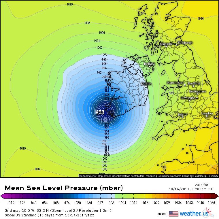
forecast models continue to show a strong impact from Ophelia which
will transition into an extra-tropical cyclone at some stage tomorrow
when it interacts with the jet stream.
We
would like to echo Met Éireann's issuance of a Status Red Warning
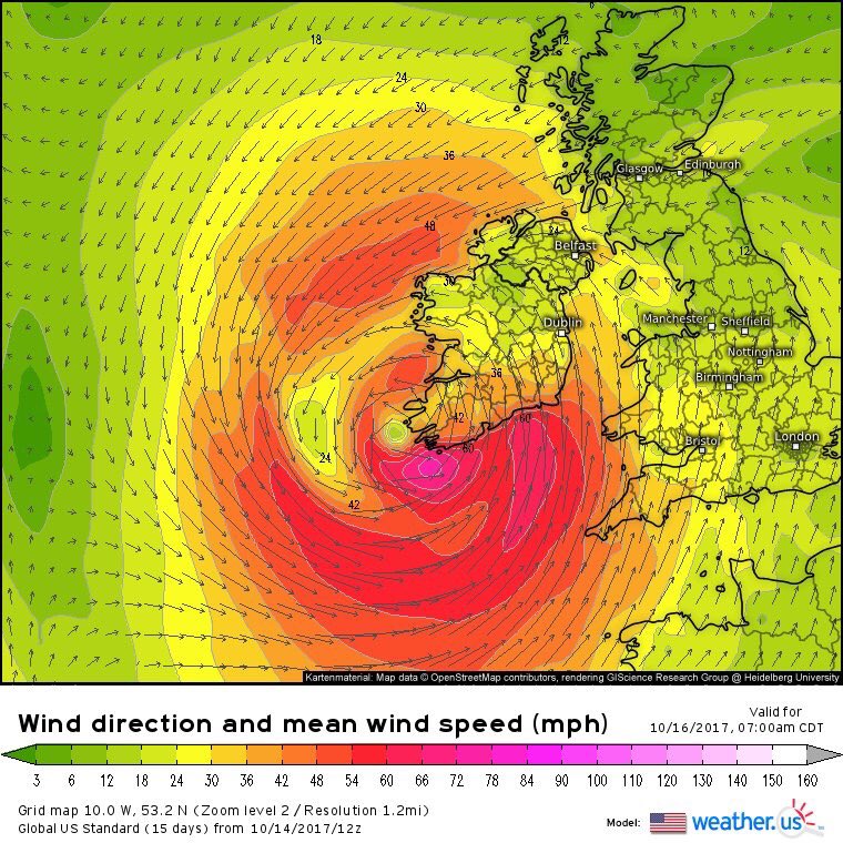
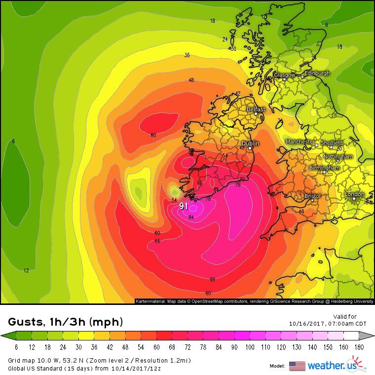
for Kerry, Cork, Clare, Galway, and Mayo. Mean wind speeds of up to
80km/hr and gusts to 130km/hr are expected, with even higher,
damaging gusts possible in exposed areas.
The
rest of the country is under a Status Orange Warning with mean winds
between 65 & 80km/hr with gusts to 130km/hr in exposed areas.
The
current timing of the storm suggests conditions to deteriorate from
daylight Monday morning in the south and not ease off until after
dark in northern areas.
Due
to the storm dynamics, damaging gusts will be possible pretty much
anywhere Monday. Driving will be especially hazardous on minor roads
surrounded by high trees and dual carriageway/motorways due to
crosswinds.
Disruptions
to power is also possible, especially in Status Red regions. Be sure
to call into elderly neighbours to notify them of the weather
warning.
Coastal
flooding is likely especially in along the south coast. Sandbag
prepping should be started in prone towns/villages.

An
incredible temperature anomaly across Europe on Monday, well above
the average as an extensive ridge covers most of our continent.
Notice the small warm core of extra-tropical system Ophelia just SW
of Ireland as well!


No comments:
Post a Comment
Note: only a member of this blog may post a comment.