Warm, Storm-Force Winds Blowing From the Equator Flip West Antarctic Winter to Summer
2
August, 2016
In
a record-hot world, there’s a lot of lower-latitude heat just
waiting for a weakness in the increasingly feeble Jet Stream to make
a big poleward rush. Such was the case today as an intense wave of
warmth exploded up from the Equatorial region and began to spread
summertime temperatures over sections of West Antarctica —
technically still in the grips of the Southern Hemisphere’s winter
season.
(A
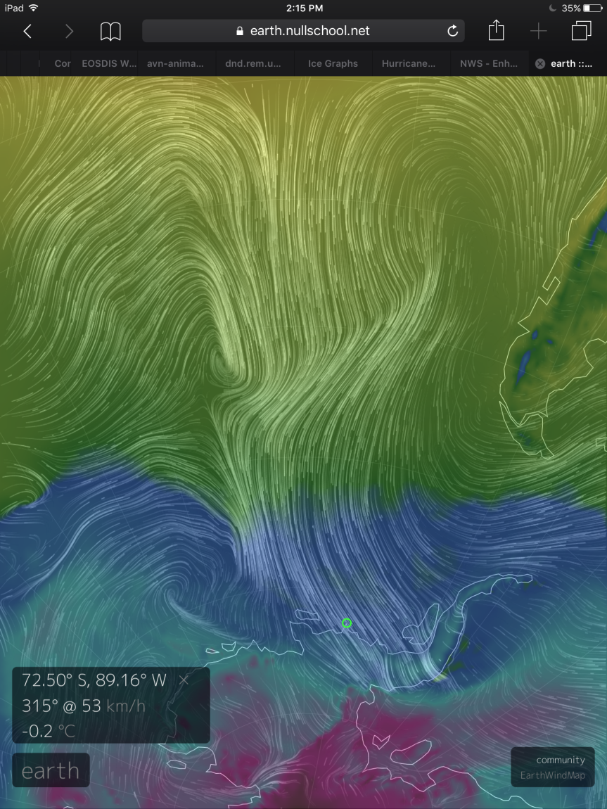
surge of heat breaks over West Antarctica on September 2nd, 2016,
pushing air temperatures over vulnerable coastal glaciers and ice
shelves near or above the melting point [0 degrees Celsius]. Image
source: Earth
Nullschool.)
The
warm winds began their southward turn about a thousand miles west of
coastal South American and along the 20 degrees south latitude line.
Tapping hot, tropical air, the winds then ran over hundreds of miles
of open ocean — following the arch of a bulging ridge in the Jet
Stream. These winds then gathered, howling through the Southern Ocean
with storm force gusts of 50 to 65 mph before delivering their
payload of abnormal warmth to West Antarctica.
Larsen
C Ice Shelf Experiencing Above-Freezing Temperatures in Winter
Along
the coast of Ellsworth Land, temperatures have risen to near the
thawing point (0 degrees C), in winter, in a region that
typically sees -2 to -3 C readings during summer. Temperatures that
are 15 to 23 C above average (27 to 40 F) now range all over the
Antarctic Peninsula and nearby areas of West Antarctica. Perhaps
most dramatic are the 1.5 C readings coming from sections of the C
region of the Larsen Ice Shelf bordering the Weddell Sea. There,
downslope hurricane-force winds howling over the shelf are helping to
spike local temperatures even as sea ice in the Weddell is splintered
and shoved away from the Larsen C edge.
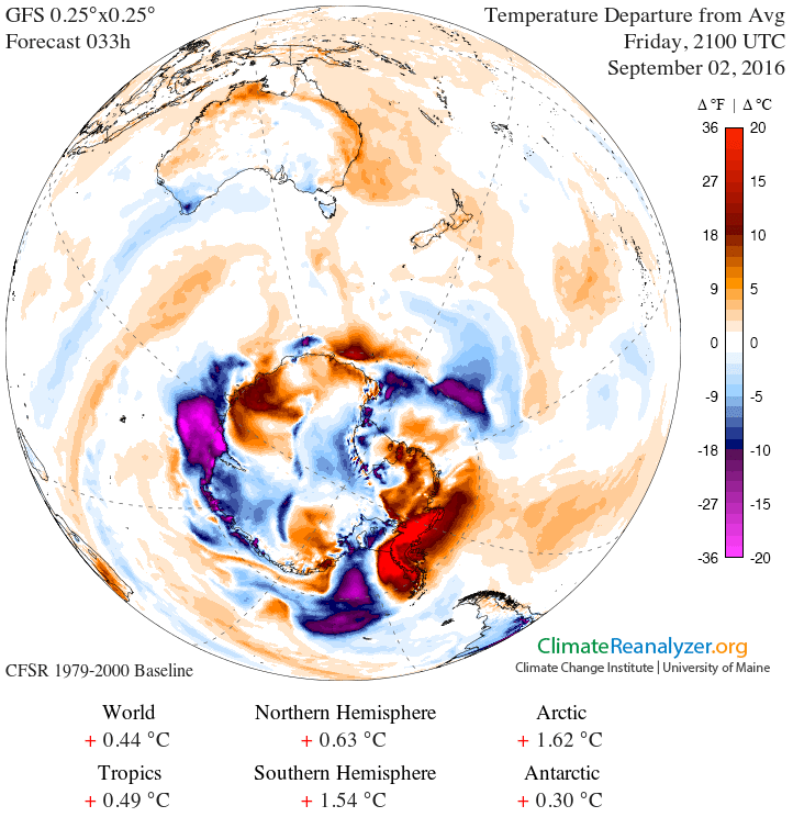
(A
wave of 20+ C [36+ F] above-average temperatures blankets the
vulnerable glaciers of West Antarctica on Friday, September 2nd. This
pulse of tropical warmth is enough to drive readings over Antarctica
to summertime or warmer ranges during winter, with some regions that
typically experience below-freezing temperatures year-round nearing
or exceeding the thawing point. Image source: Climate
Reanalyzer.)
Larsen
C is of particular interest due to a large crack spreading through
its main body,threatening
to break off a Connecticut-sized chunk of ice and disrupt the
stability of the larger ice shelf.
The most northerly of the remaining large Antarctic Peninsula ice
shelves, this towering mass of frozen water serves to buttress a
number of large Antarctic glaciers. Its loss or destabilization would
allow these glaciers to increase their speed of ocean discharge and
in turn, speed the rate of global sea-level rise. Needless to say,
this combination of above-freezing temperatures during winter and
hurricane-force winds won’t help to stabilizethis
now more than 120-kilometer long and hundreds-of-feet-deep crack.
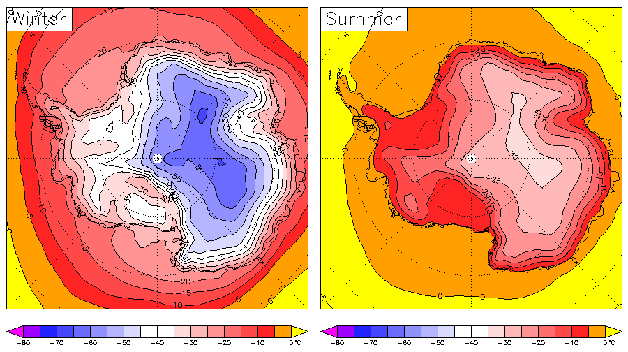
(Differences
between average summer and winter temperatures over Antarctica. For
sections of West Antarctica near the Antarctic Peninsula, Friday
through Sunday will see temperatures more typical to Antarctic summer
— during late winter. Image source:European
Center for Medium-Range Weather Forecasts.)
A
Winter of West Antarctic Heat — Larger South Pole Warm-up on the
Way?
More
broadly, warming this region to above freezing for extended periods
is a concern among glaciologists. In the past (during the Pliocene
and Miocene), when atmospheric CO2 levels have hit a range of
390-405 parts per million or above, West Antarctica (and ultimately
East Antarctica) experienced warmth which resulted in seas that were
many feet and meters higher than today. With atmospheric CO2 readings
likely to average near 405 ppm during 2016 (or total greenhouse gas
levels in the range of 490 ppm CO2e), it appears that frequent
periods of summer-like temperatures and related increasing melt
pressure are now possible during polar winter.
Over
recent months, this section of Antarctica has been clobbered
repeatedly by such spates of above-normal temperatures. Back
in June, an odd Jet Stream excursion (gravity wave) pulled a big
pulse of Equatorial heat over West Antarctica.
Today’s event is just one of a number of recent big warm air
invasions into this highly vulnerable zone.
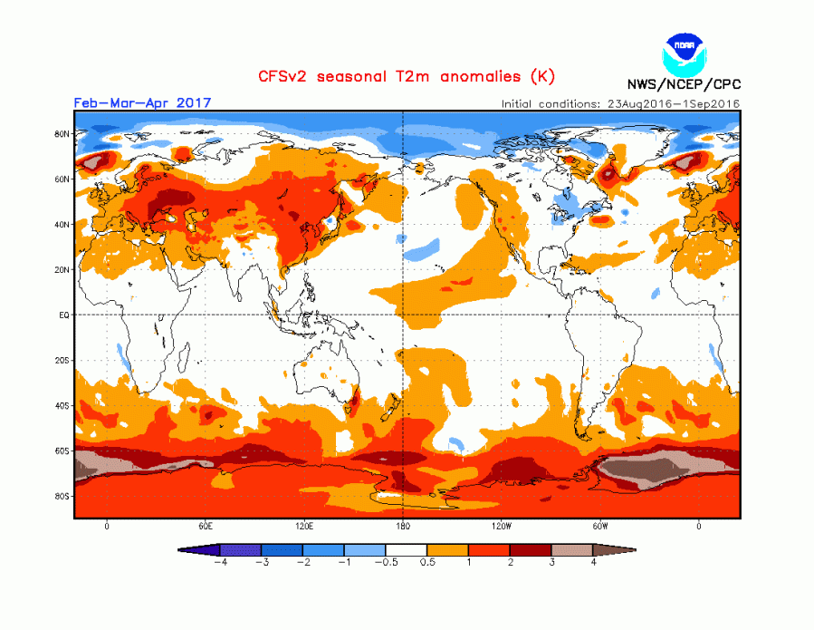
(More
severe melt stress for Antarctic glaciers? NOAA’s CFSv2 model shows
a ridiculously hot South Pole summer may be on the way. Side note —
over the past year or so this forecast model has run somewhat cooler
than actual temperatures for the Arctic region. Image source: NOAA.)
Taking
this most recent warming event into context and looking forward into
late 2016 and early 2017, at least one global forecast model is
predicting a period of severe Antarctic warming during this time.
NOAA’s CFSv2 model, for example, finds a very extreme Antarctic
temperature spike emerging over pretty much all of Antarctica during
the late Southern Hemisphere summer and early fall months of 2017.
Links:
Weather
data provided by the Global Forecast System Mode


No comments:
Post a Comment
Note: only a member of this blog may post a comment.